Geoscience Frontiers ( IF 8.5 ) Pub Date : 2021-02-20 , DOI: 10.1016/j.gsf.2021.101154 Hoang Phan Hai Yen , Binh Thai Pham , Tran Van Phong , Duong Hai Ha , Romulus Costache , Hiep Van Le , Huu Duy Nguyen , Mahdis Amiri , Nguyen Van Tao , Indra Prakash
|
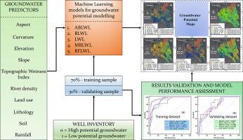
The groundwater potential map is an important tool for a sustainable water management and land use planning, particularly for agricultural countries like Vietnam. In this article, we proposed new machine learning ensemble techniques namely AdaBoost ensemble (ABLWL), Bagging ensemble (BLWL), Multi Boost ensemble (MBLWL), Rotation Forest ensemble (RFLWL) with Locally Weighted Learning (LWL) algorithm as a base classifier to build the groundwater potential map of Gia Lai province in Vietnam. For this study, eleven conditioning factors (aspect, altitude, curvature, slope, Stream Transport Index (STI), Topographic Wetness Index (TWI), soil, geology, river density, rainfall, land-use) and 134 wells yield data was used to create training (70%) and testing (30%) datasets for the development and validation of the models. Several statistical indices were used namely Positive Predictive Value (PPV), Negative Predictive Value (NPV), Sensitivity (SST), Specificity (SPF), Accuracy (ACC), Kappa, and Receiver Operating Characteristics (ROC) curve to validate and compare performance of models. Results show that performance of all the models is good to very good (AUC: 0.75 to 0.829) but the ABLWL model with AUC = 0.89 is the best. All the models applied in this study can support decision-makers to streamline the management of the groundwater and to develop economy not only of specific territories but also in other regions across the world with minor changes of the input parameters.
中文翻译:
基于局部加权学习的混合智能模型用于地下水位图和建模:以越南嘉来省为例
地下水潜力图是实现可持续水资源管理和土地利用规划的重要工具,特别是对于越南这样的农业国家而言。在本文中,我们提出了新的机器学习集成技术,即AdaBoost集成(ABLWL),袋装集成(BLWL),多重增强集成(MBLWL),旋转森林集成(RFLWL)和基于本地加权学习(LWL)算法的基本分类器。绘制越南嘉来省的地下水潜力地图。在这项研究中,使用了11个条件因子(纵横比,高度,曲率,坡度,河流运输指数(STI),地形湿度指数(TWI),土壤,地质,河流密度,降雨,土地利用)和134口井的产量数据为模型的开发和验证创建培训(70%)和测试(30%)数据集。使用了几个统计指标,即正预测值(PPV),负预测值(NPV),灵敏度(SST),特异性(SPF),准确性(ACC),卡伯值和接收器工作特性(ROC)曲线来验证和比较性能的模型。结果表明,所有模型的性能都非常好(AUC:0.75至0.829),但AUC = 0.89的ABLWL模型是最好的。本研究中使用的所有模型都可以支持决策者简化地下水管理,不仅通过特定参数的微小变化,而且不仅可以发展特定地区的经济,而且可以发展世界其他地区的经济。和接收器工作特性(ROC)曲线来验证和比较模型的性能。结果表明,所有模型的性能都非常好(AUC:0.75至0.829),但AUC = 0.89的ABLWL模型是最好的。本研究中使用的所有模型都可以支持决策者简化地下水管理,不仅通过特定参数的微小变化,而且不仅可以发展特定地区的经济,而且可以发展世界其他地区的经济。和接收器工作特性(ROC)曲线来验证和比较模型的性能。结果表明,所有模型的性能都非常好(AUC:0.75至0.829),但AUC = 0.89的ABLWL模型是最好的。本研究中使用的所有模型都可以支持决策者简化地下水管理,不仅通过特定参数的微小变化,而且不仅可以发展特定地区的经济,而且可以发展世界其他地区的经济。


 京公网安备 11010802027423号