Science of the Total Environment ( IF 8.2 ) Pub Date : 2021-02-18 , DOI: 10.1016/j.scitotenv.2021.145946 Muhagir El Kamali , Ioannis Papoutsis , Constantinos Loupasakis , Abdelgadir Abuelgasim , Khalid Omari , Charalampos Kontoes
|
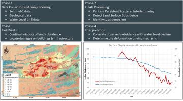
The United Arab Emirates (UAE) is located in an arid desert climate with very limited water resources and scarce rainfall. Along with the fast development of the country, the water demand for agriculture, industrial, and domestic purposes increased and led to diminishing groundwater resources. In this study, we explore the land surface deformations due to groundwater overexploitation in the agricultural area of Remah by analyzing Sentinel-1 data between 2015 and 2019 with the novel Parallelized-Persistent Scatterer Interferometry (P-PSI) technique. The detected land surface deformations have been correlated to the recorded groundwater levels at nearby water wells. This study detected land surface deformations in a form of an extensive subsidence bowl (with 28.5 km in diameter) with a maximum subsidence rate of 40 mm/year and a standard deviation within the bowl of less than 2 mm/year. The detected subsidence was associated with a 12 m drop in the water table level within the study area. The Persistent Scatterers with the highest deformations rate were spatially correlated with the depression cone of the groundwater level. These findings provide useful insights in understanding the groundwater regime of the area and have an important role in assessing regional hazards and driving mitigation measures towards managing uncontrolled groundwater overexploitation for sustainable management of groundwater resources.
中文翻译:
使用持久性散射干涉测量技术和干旱和半干旱地区的地面真实数据监测地面沉降,以阿联酋雷马为例
阿拉伯联合酋长国(UAE)处于干旱的沙漠气候,水资源非常有限,降雨稀少。随着国家的快速发展,农业,工业和家庭用水的需求增加,导致地下水资源减少。在这项研究中,我们通过使用新型平行持久散射干涉(P-PSI)技术分析了2015年至2019年之间的Sentinel-1数据,探索了雷马(Remah)农业地区地下水超采引起的地表变形。探测到的陆地表面变形已与附近水井处记录的地下水位相关。这项研究以大面积的沉降碗(有28个)的形式检测到了地表变形。直径5公里),最大下陷速率为40毫米/年,碗内的标准偏差小于2毫米/年。检测到的沉降与研究区域内地下水位下降12 m有关。变形率最高的持久散射体与地下水位的下降锥在空间上相关。这些发现为了解该地区的地下水状况提供了有用的见解,并且在评估区域危害和推动缓解措施以管理地下水不受控制的过度开采以实现地下水资源的可持续管理方面发挥着重要作用。变形率最高的持久散射体与地下水位的下降锥在空间上相关。这些发现为了解该地区的地下水状况提供了有用的见解,并且在评估区域危害和推动缓解措施以管理地下水不受控制的过度开采以实现地下水资源的可持续管理方面发挥着重要作用。变形率最高的持久散射体与地下水位的下降锥在空间上相关。这些发现为了解该地区的地下水状况提供了有用的见解,并且在评估区域危害和推动缓解措施以管理地下水不受控制的过度开采以实现地下水资源的可持续管理方面发挥着重要作用。


 京公网安备 11010802027423号