Acta Geophysica ( IF 2.0 ) Pub Date : 2021-02-18 , DOI: 10.1007/s11600-021-00551-3 Mithun Kumar , Ismail Mondal , Quoc Bao Pham
|
Abstract
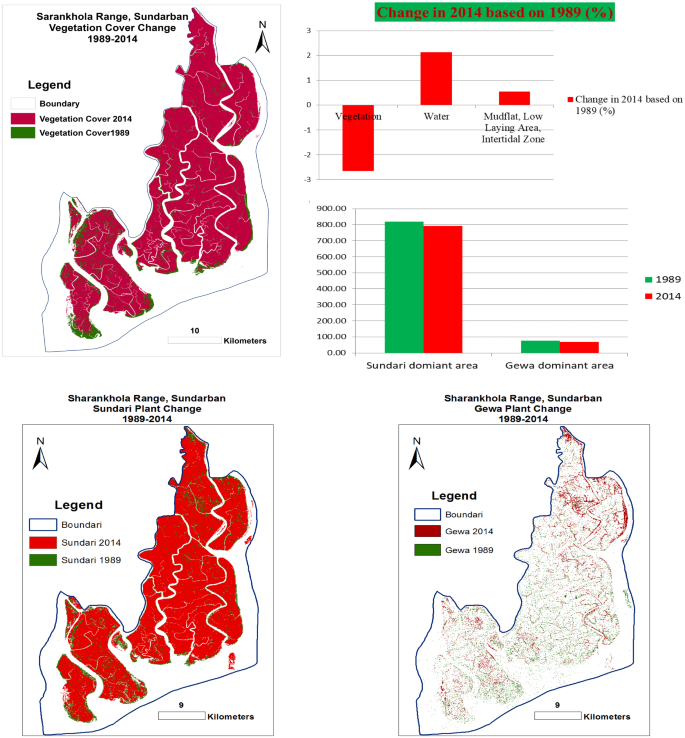
The present study aims to estimate areal extent of the mangrove forest cover in the eastern Sundarban of Bangladesh from 1989 to 2019 to understand mangrove dynamic over the last 30 years. Freely available Landsat TM of 1989, 2014, and L8 OLI imagery were used to generate land use/land cover (LU/LC) map for the study area using maximum likelihood (MaxLike) algorithm. Results of previous investigations among different scientists and researchers were used to develop a conceptual background and also included in this paper to find out the causes that relate to forest cover change in the study area. Study results show that the vegetation cover of Sharankhola range in Sundarban has decreased by 0.44% over last 30 years (from 1989 to 2019). Water body has increased (1.30%) with the decrease in vegetation cover. Classified map of 2014 and 2019 shows that 2.66% vegetation cover of the study area was lost in 2014 based on 1989 while 2.22% vegetation cover was gained in 2019 based on 2014. The overall accuracy of Landsat TM (1989), TM (2014), and L8 OLI (2019) were 80%, 82.85%, and 84.28%, respectively. Its accuracy would increase if it is supplemented by extensive ground verification data and hybrid satellite data of different spectral and spatial resolution.
Graphic Abstract
中文翻译:
监测1989年至2019年孟加拉国东部Sundarban的森林土地覆盖变化
摘要
本研究旨在估计1989年至2019年孟加拉国东部Sundarban的红树林覆盖面积,以了解过去30年的红树林动态。使用1989年,2014年免费提供的Landsat TM和L8 OLI图像,使用最大似然(MaxLike)算法生成研究区域的土地利用/土地覆盖(LU / LC)地图。不同科学家和研究人员之间先前的调查结果被用来发展概念背景,并且也包括在本文中以找出与研究区域森林覆盖率变化有关的原因。研究结果表明,过去30年(从1989年到2019年),桑达尔班Sharankhola山脉的植被覆盖率下降了0.44%。随着植被的减少,水体增加(1.30%)。2014年和2019年的分类图显示,在1989年的基础上,研究区域的植被覆盖率下降了2.66%,而在2014年的2014年的基础上,植被覆盖率达到了2.22%。Landsat TM(1989),TM(2014)的总体准确性和L8 OLI(2019)分别为80%,82.85%和84.28%。如果补充大量的地面验证数据以及具有不同光谱和空间分辨率的混合卫星数据,其准确性将会提高。


 京公网安备 11010802027423号