当前位置:
X-MOL 学术
›
Earth Surf.Process. Land.
›
论文详情
Our official English website, www.x-mol.net, welcomes your
feedback! (Note: you will need to create a separate account there.)
Late Quaternary drainage reorganization assisted by surface faulting: The example of the Katrol Hill Fault zone, Kachchh, western India
Earth Surface Processes and Landforms ( IF 2.8 ) Pub Date : 2021-02-17 , DOI: 10.1002/esp.5097 Deepak M. Maurya 1 , Prabhuti Tiwari 1 , Mohamedharoon Shaikh 1 , Atul K. Patidar 2 , Naimisha Vanik 1 , Akash Padmalal 1 , Laxman S. Chamyal 1
Earth Surface Processes and Landforms ( IF 2.8 ) Pub Date : 2021-02-17 , DOI: 10.1002/esp.5097 Deepak M. Maurya 1 , Prabhuti Tiwari 1 , Mohamedharoon Shaikh 1 , Atul K. Patidar 2 , Naimisha Vanik 1 , Akash Padmalal 1 , Laxman S. Chamyal 1
Affiliation
|
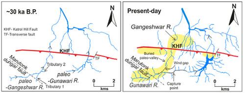
Drainage reorganization on restricted temporal and spatial scales is poorly‐documented. We attempt to decode the relatively complicated mechanism of drainage realignment involving two small rivers that show structurally controlled, highly anomalous channel networks. We provide geomorphic and shallow subsurface evidence using ground‐penetrating radar (GPR) for the presence of a buried paleo‐valley flowing northward through the wind gap and surface faulting along the range bounding Katrol Hill Fault (KHF) which correlates with the previously known three surface faulting events in last ~30 ka bp. Most of the present river channels and the KHF zone are occupied by aeolian miliolite (local name) which is stratigraphic and lithologic equivalent of the Late Quaternary carbonate rich aeolianite deposits occurring in several parts of the globe. The history of drainage evolution in the study area comprises pre‐miliolite, syn‐miliolite and post‐miliolite phases. Geomorphic evidences show that the paleo‐Gangeshwar River flowed north through the wind gap and paleo‐valley, while the short paleo‐Gunawari occupied the saddle zone to the east of Ler dome prior to and during the phase of miliolite deposition which ended by ~40 ka bp. Southward tilting of the Katrol Hill Range (KHR) due to surface faulting cut off the catchment of the paleo‐Gangeshwar River. The abandoned catchment stream extended its channel eastward along the strike through top‐down process while the paleo‐Gunawari River extended its course westward by headward erosion (bottom‐up process). As the channels advanced towards each other they joined to produce the “S”‐shaped bend which formed the capture point. We conclude that multiple surface faulting events along the KHF in the last ~30 ka bp, resulted in uplift and tilting of the KHR which caused drainage realignment by river diversion, beheading and river capture. Our study shows that the complexity of drainage reorganization processes is more explicit on shorter rather than longer timescales.
中文翻译:

地表断层辅助晚期第四纪排水重组:以印度西部卡切尔的卡特罗山断裂带为例
有限的时空尺度上的排水改组文献不多。我们试图对涉及两条小河的排水调整的相对复杂的机制进行解码,这些小河显示出结构受控,高度异常的河道网络。我们使用探地雷达(GPR)提供地貌和浅层地下证据,以了解存在一个埋藏的古河谷向北流经风隙和沿卡特罗尔山断裂带(KHF)边界范围的地表断层,这与先前已知的三个最后约30 ka bp的地表断层事件。目前的大多数河道和KHF带都被风成粉状硅镁石(当地名称)所占据,这与全球若干地区的富含第四纪晚期碳酸盐的风成岩矿床在地层和岩性上是等价的。研究区的排水演化历史包括前闪长石,顺闪长石和后闪长石阶段。地貌证据表明,古冈什瓦河向北流经风隙和古谷,而短古古冈瓦里则在粟粒岩沉积之前和之中占据了勒圆顶东部的鞍状带,并在此阶段结束了约40年。 KA基点。由于地表断层,卡特罗山山脉(KHR)向南倾斜,切断了古冈什瓦尔河的流域。废弃的集水流通过自上而下的过程沿罢工向东扩展其河道,而古古瓦瓦里河则因向前侵蚀而向西扩展其路线(自下而上的过程)。随着通道相互靠近,它们汇合在一起,形成了“ S”形弯曲,形成了捕获点。我们得出的结论是,在最后一个约30 ka bp处,沿KHF发生了多个表面断层事件,导致KHR的抬升和倾斜,这通过引流,斩首和捕获河道引起了排水系统的重新排列。我们的研究表明,排水重组过程的复杂性在较短而不是较长的时间范围内更为明显。
更新日期:2021-03-17
中文翻译:
地表断层辅助晚期第四纪排水重组:以印度西部卡切尔的卡特罗山断裂带为例
有限的时空尺度上的排水改组文献不多。我们试图对涉及两条小河的排水调整的相对复杂的机制进行解码,这些小河显示出结构受控,高度异常的河道网络。我们使用探地雷达(GPR)提供地貌和浅层地下证据,以了解存在一个埋藏的古河谷向北流经风隙和沿卡特罗尔山断裂带(KHF)边界范围的地表断层,这与先前已知的三个最后约30 ka bp的地表断层事件。目前的大多数河道和KHF带都被风成粉状硅镁石(当地名称)所占据,这与全球若干地区的富含第四纪晚期碳酸盐的风成岩矿床在地层和岩性上是等价的。研究区的排水演化历史包括前闪长石,顺闪长石和后闪长石阶段。地貌证据表明,古冈什瓦河向北流经风隙和古谷,而短古古冈瓦里则在粟粒岩沉积之前和之中占据了勒圆顶东部的鞍状带,并在此阶段结束了约40年。 KA基点。由于地表断层,卡特罗山山脉(KHR)向南倾斜,切断了古冈什瓦尔河的流域。废弃的集水流通过自上而下的过程沿罢工向东扩展其河道,而古古瓦瓦里河则因向前侵蚀而向西扩展其路线(自下而上的过程)。随着通道相互靠近,它们汇合在一起,形成了“ S”形弯曲,形成了捕获点。我们得出的结论是,在最后一个约30 ka bp处,沿KHF发生了多个表面断层事件,导致KHR的抬升和倾斜,这通过引流,斩首和捕获河道引起了排水系统的重新排列。我们的研究表明,排水重组过程的复杂性在较短而不是较长的时间范围内更为明显。


 京公网安备 11010802027423号