当前位置:
X-MOL 学术
›
Earth Surf.Process. Land.
›
论文详情
Our official English website, www.x-mol.net, welcomes your feedback! (Note: you will need to create a separate account there.)
Quantifying the spatial distribution of sediment transport in an experimental gully system using the morphological method
Earth Surface Processes and Landforms ( IF 3.3 ) Pub Date : 2021-02-15 , DOI: 10.1002/esp.5094 Wen Dai 1, 2, 3 , Liyang Xiong 1, 3, 4 , Gilles Antoniazza 2 , Guoan Tang 1, 3, 4 , Stuart N. Lane 2
Earth Surface Processes and Landforms ( IF 3.3 ) Pub Date : 2021-02-15 , DOI: 10.1002/esp.5094 Wen Dai 1, 2, 3 , Liyang Xiong 1, 3, 4 , Gilles Antoniazza 2 , Guoan Tang 1, 3, 4 , Stuart N. Lane 2
Affiliation
|
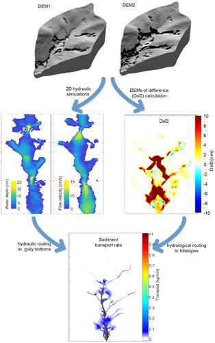
Whilst time-series of sediment transport in gullies in both laboratory experimental and field settings can be determined through instrumentation, quantifying the spatial distribution of transport rates remains challenging. The morphological method, which was proposed for estimating bed-material transport in both one- and two-dimensions in rivers, provides an alternative. Here, we developed this method for gully systems. A laboratory catchment was used to simulate gully erosion. High-resolution topographical data were acquired by close-range digital photogrammetry. Morphological changes were determined using high-resolution topographic data and an associated level of detection. Based on measured morphological changes, one-dimensional (1D) and two-dimensional (2D) sediment transport rates were calculated via cross-section by cross-section routing (1D) and cell by cell routing (2D). The 1D application provided a general trend of longitudinal variation of sediment transport for the whole gully system, increased gradually from zones of headward extension to a zone downstream where erosion and deposition were in balance, and sediment transport rates less variable in space. For the 2D application, hydrological and blended hydrological-hydraulic routing solutions were compared. We found that the level of negative transport was insensitive to whether or not a blended hydrological-hydraulic routing was used and that results from applying the hydrological routing throughout were not significantly degraded. We also found that consideration should be given to spatial and temporal resolution of the topographic data. The 2D application provided spatial patterns of sediment transport that vary with gully evolution. The main gully remained a high transport corridor but branch transport became more important through time. The framework we report provides an additional tool for both experimental and field quantification of the spatial patterns of sediment transport in gullies; and quantification of how these patterns change under different forcing factors.
中文翻译:

使用形态学方法量化实验性沟渠系统中泥沙运移的空间分布
尽管可以通过仪器来确定实验室实验和野外环境中沟渠中泥沙运移的时间序列,但对运移速率的空间分布进行量化仍然具有挑战性。提出了一种形态学方法,用于估算河流中一维和二维水床中的物质运移,这提供了另一种方法。在这里,我们为沟渠系统开发了这种方法。实验室集水区被用来模拟沟壑侵蚀。通过近距离数字摄影测量获得高分辨率的地形数据。使用高分辨率的地形数据和相关的检测水平来确定形态变化。根据测得的形态变化,一维(1D)和二维(2D)沉积物传输速率是通过横截面截面路由(1D)和细胞逐细胞路由(2D)计算的。一维应用程序提供了整个沟渠系统泥沙输送纵向变化的总体趋势,从朝前延伸的区域逐渐增加到侵蚀和沉积达到平衡的下游区域,泥沙输送速率在空间中的变化较小。对于2D应用程序,比较了水文和水文液压混合路径解决方案。我们发现负向运输的水平对于是否使用混合水文-水力路线不敏感,并且整个应用水文路线的结果不会显着降低。我们还发现应该考虑地形数据的时空分辨率。2D应用程序提供了随着沟壑演变而变化的沉积物迁移的空间模式。主要沟壑仍然是高运输走廊,但随着时间的流逝,分支运输变得越来越重要。我们报告的框架提供了一个额外的工具,用于实验和野外量化沟渠中泥沙运移的空间模式;并量化这些模式在不同强迫因素下如何变化。我们报告的框架提供了一个额外的工具,用于实验和野外量化沟渠中泥沙运移的空间模式;并量化这些模式在不同强迫因素下如何变化。我们报告的框架提供了一个额外的工具,用于实验和野外量化沟渠中泥沙运移的空间模式;并量化这些模式在不同强迫因素下如何变化。
更新日期:2021-02-15
中文翻译:
使用形态学方法量化实验性沟渠系统中泥沙运移的空间分布
尽管可以通过仪器来确定实验室实验和野外环境中沟渠中泥沙运移的时间序列,但对运移速率的空间分布进行量化仍然具有挑战性。提出了一种形态学方法,用于估算河流中一维和二维水床中的物质运移,这提供了另一种方法。在这里,我们为沟渠系统开发了这种方法。实验室集水区被用来模拟沟壑侵蚀。通过近距离数字摄影测量获得高分辨率的地形数据。使用高分辨率的地形数据和相关的检测水平来确定形态变化。根据测得的形态变化,一维(1D)和二维(2D)沉积物传输速率是通过横截面截面路由(1D)和细胞逐细胞路由(2D)计算的。一维应用程序提供了整个沟渠系统泥沙输送纵向变化的总体趋势,从朝前延伸的区域逐渐增加到侵蚀和沉积达到平衡的下游区域,泥沙输送速率在空间中的变化较小。对于2D应用程序,比较了水文和水文液压混合路径解决方案。我们发现负向运输的水平对于是否使用混合水文-水力路线不敏感,并且整个应用水文路线的结果不会显着降低。我们还发现应该考虑地形数据的时空分辨率。2D应用程序提供了随着沟壑演变而变化的沉积物迁移的空间模式。主要沟壑仍然是高运输走廊,但随着时间的流逝,分支运输变得越来越重要。我们报告的框架提供了一个额外的工具,用于实验和野外量化沟渠中泥沙运移的空间模式;并量化这些模式在不同强迫因素下如何变化。我们报告的框架提供了一个额外的工具,用于实验和野外量化沟渠中泥沙运移的空间模式;并量化这些模式在不同强迫因素下如何变化。我们报告的框架提供了一个额外的工具,用于实验和野外量化沟渠中泥沙运移的空间模式;并量化这些模式在不同强迫因素下如何变化。


 京公网安备 11010802027423号