Computers, Environment and Urban Systems ( IF 7.1 ) Pub Date : 2021-02-16 , DOI: 10.1016/j.compenvurbsys.2021.101595 Hossein Shafizadeh-Moghadam , Masoud Minaei , Robert Gilmore Pontius Jr , Ali Asghari , Hashem Dadashpoor
|
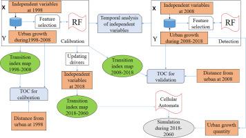
This paper couples a Forward Feature Selection algorithm with Random Forest (FFS-RF) to create a transition index map, which then guides the spatial allocation for the extrapolation of urban growth using a Cellular Automata model. We used Landsat imagery to generate land cover maps at the years 1998, 2008, and 2018 for the Tehran-Karaj Region (TKR) in Iran. The FFS-RF considered the independent variables of slope, altitude, and distances from urban, crop, greenery, barren, and roads. The FFS-RF revealed temporal non-stationary of drivers from 1998–2008 to 2008–2018. The FFS-RF detected that altitude and distance from greenery were the most important drivers of urban growth during 1998–2008, then distances from crop and barren were the most important drivers during 2008–2018. We used the Total Operating Characteristic to evaluate the transition index maps. Validation during 2008–2018 showed that FFS-RF produced a transition index map that had predictive power no better than an allocation of urban growth near existing urban. Simulation to 2060 extrapolated that Tehran, Karaj, and their adjacent cities will interconnect spatially to form a gigantic city-region.
中文翻译:
集成前向特征选择算法,随机森林和元胞自动机以推断伊朗德黑兰-卡拉杰地区的城市发展
本文将前向特征选择算法与随机森林(FFS-RF)耦合以创建过渡索引图,然后使用Cellular Automata模型为城市增长的外推提供指导的空间分配。我们使用Landsat影像在1998年,2008年和2018年为伊朗的德黑兰-卡拉杰地区(TKR)生成了土地覆盖图。FFS-RF考虑了坡度,海拔高度以及与城市,农作物,绿化,贫瘠和道路的距离的自变量。FFS-RF揭示了1998-2008年至2008-2018年期间驾驶员的暂时性不稳定。FFS-RF发现,海拔高度和距绿化的距离是1998-2008年期间城市增长的最重要驱动力,然后距农作物和荒芜的距离是2008-2018年期间最重要的驱动力。我们使用总运行特征来评估过渡指数图。2008-2018年期间的验证表明,FFS-RF制作了一个过渡指数图,该图的预测力不比现有城市附近的城市增长分配好。到2060年的模拟推断,德黑兰,卡拉伊及其邻近城市将在空间上相互连接,形成一个巨大的城市区域。


 京公网安备 11010802027423号