Progress in Earth and Planetary Science ( IF 3.5 ) Pub Date : 2021-02-12 , DOI: 10.1186/s40645-021-00408-9 Hiroshi Matsuyama , Hitoshi Saito , Valerii Zemtsov
|
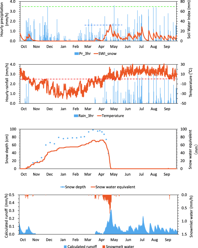
Soil Water Index (SWI) represents the conceptual water stored in the soil and is calculated using a three-layer tank model with hourly precipitation. In Japan, landslide disasters are likely to occur when SWI in an event exceeds the maximum value of the past 10 years; however, snowmelt-driven landslide disasters have not been considered yet. Using the tank model that simultaneously calculates SWI and runoff, we implemented the snowfall-accumulation-snowmelt processes into the original SWI and applied the modified SWI to meteorological data in Tomsk, Russia, in spring 2010 when severe flood and landslide disasters had occurred. We conducted a sensitivity analysis of hourly precipitation in snowy region in Japan considering that meteorological data in Russia are available every 3 h. When we input the average of the three-hourly accumulated precipitation to calculate SWI, the result was almost identical to that of the observed hourly precipitation being given. We then estimated the hourly temperature by linearly interpolating the data every 3 h, and set the threshold of liquid/solid precipitation. The degree-hour method was employed to calculate the snowmelt. The modified SWI predicted the occurrence of snowmelt-driven landslide disasters in Japan when the calculated SWI exceeded the maximum value in the snowmelt season (March–May) for the past 10 years. When applied to meteorological data in Tomsk, the modified SWI and calculated runoff captured the timing of snowmelt-driven flood and landslide disasters in spring 2010. We demonstrated that by focusing on the maximum value of SWI in the snowmelt season for the past 10 years, we can predict snowmelt-driven landslide disasters.
中文翻译:
土壤水分指数在多雪地区滑坡预测中的应用:日本的敏感性分析和俄罗斯托木斯克的初步结果
土壤水分指数(SWI)代表概念土壤中存储的水分,并使用三层水箱模型和每小时降水量进行计算。在日本,如果SWI超过过去10年的最大值,则很可能发生滑坡灾害。但是,尚未考虑融雪驱动的滑坡灾害。使用同时计算SWI和径流量的储罐模型,我们在原始SWI中实现了降雪积雪融化过程,并将修改后的SWI应用于2010年春季发生严重洪灾和滑坡灾害的俄罗斯托木斯克的气象数据。考虑到俄罗斯每3小时可获得一次气象数据,我们对日本多雪地区的每小时降水进行了敏感性分析。当我们输入三个小时累积降水量的平均值来计算SWI时,结果几乎与观察到的每小时降水量相同。然后,我们通过每3小时对数据进行线性插值来估计每小时的温度,并设置液/固沉淀的阈值。采用度小时法计算融雪量。修改后的SWI预测,当计算的SWI超过过去10年的融雪季节(3月至5月)的最大值时,日本会发生融雪驱动的滑坡灾害。将修正后的SWI和计算出的径流量应用于托木斯克的气象数据后,可以捕捉到2010年春季融雪驱动的洪水和滑坡灾害的发生时间。我们证明,通过关注过去10年融雪季节SWI的最大值,


 京公网安备 11010802027423号