当前位置:
X-MOL 学术
›
Remote Sens. Ecol. Conserv.
›
论文详情
Our official English website, www.x-mol.net, welcomes your
feedback! (Note: you will need to create a separate account there.)
Remotely piloted aircraft systems remote sensing can effectively retrieve ecosystem traits of alpine grasslands on the Tibetan Plateau at a landscape scale
Remote Sensing in Ecology and Conservation ( IF 3.9 ) Pub Date : 2021-02-02 , DOI: 10.1002/rse2.196 Ze Tang 1, 2 , Yangjian Zhang 1, 2, 3 , Nan Cong 1 , Li Wang 4 , Yixuan Zhu 1, 2 , Zhaolei Li 5 , Guang Zhao 1
Remote Sensing in Ecology and Conservation ( IF 3.9 ) Pub Date : 2021-02-02 , DOI: 10.1002/rse2.196 Ze Tang 1, 2 , Yangjian Zhang 1, 2, 3 , Nan Cong 1 , Li Wang 4 , Yixuan Zhu 1, 2 , Zhaolei Li 5 , Guang Zhao 1
Affiliation
|
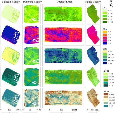
Ecosystem trait is a standardized description of biological features of a community, and it bridges individual plants and ecosystem. Conventionally most ecosystem trait data are collected from field survey and the generated data is hard to meet the requirements as set in the concept of ecosystem trait. To a great extent, remotely piloted aircraft systems (RPAS) remote sensing, which is capable of retrieving ecosystem traits across multiple scales, can overcome constraints in field plot survey. In this study, we selected alpine grassland ecosystem on the Tibetan Plateau (TP), which is under-studied due to scarcity of field monitoring data, as the research target. A new data framework was proposed by integrating field plot and RPAS remote sensing data to map spatial patterns of ecosystem traits for the alpine grasslands. Across four landscapes on the TP, ecosystem traits of vegetation coverage (CVC), species number (CSN), individual number (CIN), above ground biomass (AGB), organic carbon content (OC%) and total nitrogen content (TN%) were retrieved. We also calculated Shannon's Diversity Index and Shannon's Evenness Index for each plot. The results showed that RPAS-based high spatial resolution RGB image is capable of predicting both physical and chemical ecosystem traits for alpine grasslands on the TP. Remote sensing on physical traits are overall more efficient than on chemical traits, with the highest R2 of 0.86 and 0.48 for physical trait and chemical one, respectively. The bands of Red and Green contributed more to the prediction model than band of Blue did, and the spectral mean value played a greater role than the spectral standard deviation. Based on the retrieved results, a set of spatial patterns on ecosystem traits can be revealed. This study represents an advance on ecosystem trait study and can significantly improve our understanding on ecosystem functions of the alpine ecosystem on the TP.
中文翻译:

无人机系统遥感可在景观尺度上有效反演青藏高原高寒草原生态系统特征
生态系统性状是对群落生物特征的标准化描述,它是个体植物和生态系统之间的桥梁。传统上大多数生态系统特征数据是通过实地调查收集的,生成的数据很难满足生态系统特征概念中设定的要求。在很大程度上,能够在多个尺度上检索生态系统特征的遥控飞机系统(RPAS)遥感可以克服实地调查中的限制。在本研究中,我们选择了由于缺乏实地监测数据而未被充分研究的青藏高原(TP)高寒草地生态系统作为研究对象。通过整合田间地块和 RPAS 遥感数据,提出了一种新的数据框架,用于绘制高寒草原生态系统特征的空间格局。跨越青藏高原的四个景观,植被覆盖度(CVC)、物种数(CSN)、个体数(CIN)、地上生物量(AGB)、有机碳含量(OC%)和总氮含量(TN%)的生态系统特征被检索。我们还计算了每个地块的香农多样性指数和香农均匀度指数。结果表明,基于 RPAS 的高空间分辨率RGB图像能够预测青藏高原高寒草地的物理和化学生态系统特征。物理性状遥感总体上比化学性状更有效,物理性状和化学性状的最高R 2 分别为0.86和0.48。红色和绿色波段对预测模型的贡献大于蓝色波段,光谱平均值比光谱标准偏差的作用更大。根据检索结果,可以揭示一组生态系统特征的空间模式。该研究代表了生态系统特征研究的进步,可以显着提高我们对青藏高原高寒生态系统生态系统功能的理解。
更新日期:2021-02-02
中文翻译:
无人机系统遥感可在景观尺度上有效反演青藏高原高寒草原生态系统特征
生态系统性状是对群落生物特征的标准化描述,它是个体植物和生态系统之间的桥梁。传统上大多数生态系统特征数据是通过实地调查收集的,生成的数据很难满足生态系统特征概念中设定的要求。在很大程度上,能够在多个尺度上检索生态系统特征的遥控飞机系统(RPAS)遥感可以克服实地调查中的限制。在本研究中,我们选择了由于缺乏实地监测数据而未被充分研究的青藏高原(TP)高寒草地生态系统作为研究对象。通过整合田间地块和 RPAS 遥感数据,提出了一种新的数据框架,用于绘制高寒草原生态系统特征的空间格局。跨越青藏高原的四个景观,植被覆盖度(CVC)、物种数(CSN)、个体数(CIN)、地上生物量(AGB)、有机碳含量(OC%)和总氮含量(TN%)的生态系统特征被检索。我们还计算了每个地块的香农多样性指数和香农均匀度指数。结果表明,基于 RPAS 的高空间分辨率RGB图像能够预测青藏高原高寒草地的物理和化学生态系统特征。物理性状遥感总体上比化学性状更有效,物理性状和化学性状的最高R 2 分别为0.86和0.48。红色和绿色波段对预测模型的贡献大于蓝色波段,光谱平均值比光谱标准偏差的作用更大。根据检索结果,可以揭示一组生态系统特征的空间模式。该研究代表了生态系统特征研究的进步,可以显着提高我们对青藏高原高寒生态系统生态系统功能的理解。


 京公网安备 11010802027423号