Remote Sensing of Environment ( IF 11.1 ) Pub Date : 2021-01-29 , DOI: 10.1016/j.rse.2020.112197 Dan J. Dixon , J. Nikolaus Callow , John M.A. Duncan , Samantha A. Setterfield , Natasha Pauli
|
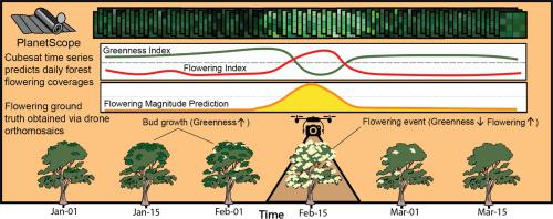
Knowledge of flowering phenology is essential for understanding the condition of forest ecosystems and responses to various anthropogenic and environmental drivers. However, monitoring the spatial and temporal variability in forest flowering at landscape scales is challenging (e.g. current monitoring is often highly localized and in-situ or for single dates). This study presents a method that combines drone and satellite images (PlanetScope) that can produce landscape-scale maps of flowering dynamics. This method is demonstrated in forest landscapes dominated by the eucalypt Corymbia calophylla (red gum or marri) in Western Australia. Drone-derived images of flowering eucalypt canopies, available for restricted temporal and spatial extents, are used to label satellite image pixels with the proportion of a pixel footprint that is flowering. The pixels labelled with flowering proportion, the response variable, are combined with various metrics that characterize time series of spectral indices sensitive to the presence of green vegetation and cream-colored flowers, the predictor variables. A machine learning model then predicts daily pixel-level flowering proportions. The model is trained with data from two sites and is tested with data from three sites and various dates throughout the Corymbia calophylla season. The model is able to accurately predict pixel-level flowering proportion throughout the flowering season (RMSE <4% across all sites and dates), across sites with dense to sparse canopy, different background soil covers, and is robust to not detecting false positive flowering when no flowering events are occurring. Due to the spatiotemporal coverage of satellite images, this model can be deployed to generate regional maps of flowering dynamics in forest ecosystems that can be used for monitoring forest ecosystem condition and supporting research into drivers of eucalypt forest phenology.
中文翻译:
森林开花物候的卫星预测
开花物候的知识对于理解森林生态系统的状况以及对各种人为和环境驱动因素的响应至关重要。然而,在景观尺度上监测森林开花的时空变化具有挑战性(例如,目前的监测往往高度局限在原地或单日)。这项研究提出了一种结合无人机和卫星图像(PlanetScope)的方法,该方法可以生成开花动态的景观比例图。这种方法在以桉树Corymbia calophylla为主的森林景观中得到了证明(西澳大利亚州的红胶或马里)。可用于有限的时间和空间范围的无花果桉树冠层的无人机图像用于标记卫星图像像素,其中所占像素的比例是开花的。用开花比例标记的像素(响应变量)与各种度量结合在一起,这些度量表征对绿色植被和米色花朵(预测变量)的存在敏感的光谱指数的时间序列。然后,机器学习模型将预测每日像素级别的开花比例。使用来自两个地点的数据对模型进行训练,并使用来自三个地点的数据以及整个Corymbia calophylla的不同日期进行了测试。季节。该模型能够准确地预测整个开花季节(在所有地点和日期的RMSE <4%),顶棚密实到稀疏,背景土壤覆盖不同的地点的像素级开花比例,并且对于不检测假阳性开花具有鲁棒性当没有开花事件发生时。由于卫星图像的时空覆盖,可以使用此模型来生成森林生态系统中开花动态的区域地图,该地图可用于监视森林生态系统状况并支持对桉树森林物候学驱动因素的研究。


 京公网安备 11010802027423号