当前位置:
X-MOL 学术
›
Basin Res.
›
论文详情
Our official English website, www.x-mol.net, welcomes your
feedback! (Note: you will need to create a separate account there.)
A regional CO2 containment assessment of the northern Utsira Formation seal and overburden, northern North Sea
Basin Research ( IF 2.8 ) Pub Date : 2021-01-23 , DOI: 10.1111/bre.12545 C. Lloyd 1 , M. Huuse 1 , B.J. Barrett 2 , M.A. Stewart 3 , A.M.W. Newton 4
Basin Research ( IF 2.8 ) Pub Date : 2021-01-23 , DOI: 10.1111/bre.12545 C. Lloyd 1 , M. Huuse 1 , B.J. Barrett 2 , M.A. Stewart 3 , A.M.W. Newton 4
Affiliation
|
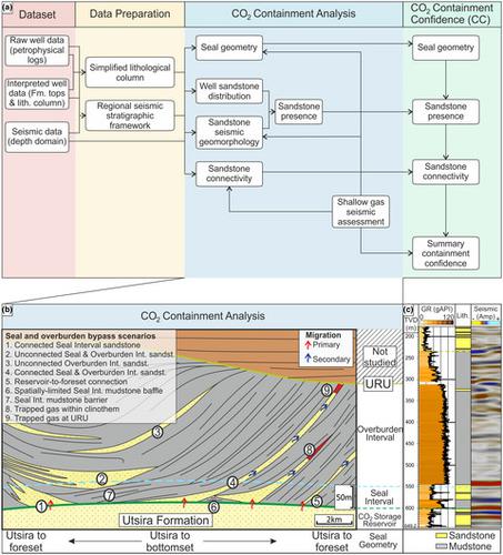
Upscaling Carbon Capture and Storage requires identification of suitable storage sites, with robust reservoir seals. The Utsira Formation in the northern North Sea has been flagged as a target for further storage. However, there are no regional studies of seal variability addressing heterogeneities that could facilitate seal bypass. This study aims to: (a) identify, assess and map the elements that promote or restrict fluid migration, (b) develop a matrix to regionally map containment confidence (CC) and (c) rank the different areas for CO2 containment across the Utsira Formation. The seal and overburden were mapped using a high-resolution, pre-stack depth-migrated 3D broadband seismic reflection dataset and 141 exploration wells. Seal geometry, sandstone presence and sandstone connectivity in the seal and overburden were assigned relative CC scores, which were summed to map overall CC of the Utsira Fm. Indicators for shallow gas and migration were mapped and correlated with the other elements. Areas with the lowest CC are in the west of the Utsira Fm. Here, sandstones within the Seal Interval are connected through the overburden via sandy submarine fans. In the southeast, dipping stratigraphy downlaps onto the Utsira Fm., increasing the potential for connection with glacially-derived channel-lobe systems in the overburden. The areas with the highest CC are the central and northeast parts of the Utsira Fm., where the Seal Interval is mudstone-dominated and parallel to the reservoir, and channel-lobe systems identified in the Overburden Interval are disconnected from the reservoir. This area coincides with a thick depocentre of the northern Utsira Fm. These results can be used to inform CO2 storage site selection and constrain future CO2 plume simulation analyses for the Utsira Fm. The CC matrix outlined here can also be adapted and applied to regionally assess the containment of other potential CO2 storage reservoirs in any setting.
中文翻译:

北海北部Utsira组海豹和覆盖层的区域CO2围堵评估
升级碳捕集与封存需要确定合适的存储地点,并使用坚固的储层密封件。北海北部的Utsira组已被标记为进一步储存的目标。但是,目前尚无针对可促进密封旁路的异质性的密封变化研究的区域性研究。这项研究的目的是:(a)识别,评估和绘制促进或限制流体运移的要素,(b)建立矩阵以在区域范围内绘制密闭度置信度(CC),以及(c)对不同地区的CO 2整个Utsira编队的安全壳。使用高分辨率,叠前深度偏移的3D宽带地震反射数据集和141个探井对海豹和覆盖层进行了测绘。为海豹的几何形状,海豹的存在以及在海豹和上覆岩层中的砂岩连通性指定了相对CC得分,这些得分相加以绘制Utsira Fm的总体CC。绘制了浅层气体和运移指标,并将其与其他要素关联起来。CC最低的区域位于Utsira Fm的西部。在这里,“海豹间隔”内的砂岩通过沙质海底风扇通过覆盖层连接。在东南部,地层向下倾覆到Utsira Fm。上,增加了与上覆层中冰川成因的河道-垂脉系统联系的可能性。CC最高的区域是Utsira Fm的中部和东北部,那里的海豹层段以泥岩为主,与储层平行,并且在上覆层段中识别出的河道系统与储层断开连接。该地区与北部Utsira Fm的厚沉积中心相吻合。这些结果可用于告知CO2个存储地点的选择,并限制Utsira Fm的未来CO 2羽流模拟分析。在此概述的CC矩阵也可以进行调整,并应用于在任何情况下区域评估其他潜在CO 2储存库的容纳度。
更新日期:2021-01-23
中文翻译:
北海北部Utsira组海豹和覆盖层的区域CO2围堵评估
升级碳捕集与封存需要确定合适的存储地点,并使用坚固的储层密封件。北海北部的Utsira组已被标记为进一步储存的目标。但是,目前尚无针对可促进密封旁路的异质性的密封变化研究的区域性研究。这项研究的目的是:(a)识别,评估和绘制促进或限制流体运移的要素,(b)建立矩阵以在区域范围内绘制密闭度置信度(CC),以及(c)对不同地区的CO 2整个Utsira编队的安全壳。使用高分辨率,叠前深度偏移的3D宽带地震反射数据集和141个探井对海豹和覆盖层进行了测绘。为海豹的几何形状,海豹的存在以及在海豹和上覆岩层中的砂岩连通性指定了相对CC得分,这些得分相加以绘制Utsira Fm的总体CC。绘制了浅层气体和运移指标,并将其与其他要素关联起来。CC最低的区域位于Utsira Fm的西部。在这里,“海豹间隔”内的砂岩通过沙质海底风扇通过覆盖层连接。在东南部,地层向下倾覆到Utsira Fm。上,增加了与上覆层中冰川成因的河道-垂脉系统联系的可能性。CC最高的区域是Utsira Fm的中部和东北部,那里的海豹层段以泥岩为主,与储层平行,并且在上覆层段中识别出的河道系统与储层断开连接。该地区与北部Utsira Fm的厚沉积中心相吻合。这些结果可用于告知CO2个存储地点的选择,并限制Utsira Fm的未来CO 2羽流模拟分析。在此概述的CC矩阵也可以进行调整,并应用于在任何情况下区域评估其他潜在CO 2储存库的容纳度。


 京公网安备 11010802027423号