Geomorphology ( IF 3.1 ) Pub Date : 2021-01-19 , DOI: 10.1016/j.geomorph.2021.107620 Szymon Śledź , Marek Ewertowski , Jan Piekarczyk
|
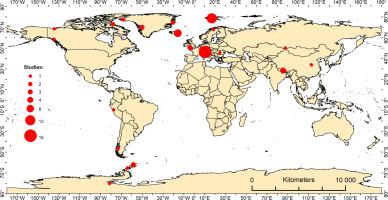
Unmanned aerial vehicles (UAVs, UAS, drones) combined with Structure-from-Motion (SfM) photogrammetry have emerged over the last decade as the basis for a very efficient workflow in glacial and periglacial geomorphology by filling the spatial gap between traditional ground-based surveys and aerial or satellite remote sensing data. UAV-generated data offer flexible spatial and temporal resolution, thus enabling a shift from a pure description of geomorphological forms to a better understanding of process-form relationships, e.g., by quantification of short-term landscape changes in response to various drivers. In this contribution, we present an overview of current applications of UAV-SfM in studies of modern and past glacial environments that include mostly geomorphological mapping and change-detection analysis. We also indicate potential future applications, e.g., by combining UAV-data with historical archives, terrestrial SfM, and crowd-based image gathering to allow for a better understanding of landscape changes in response to present climate warming.
中文翻译:
运动摄影测量技术在无人机上的应用和结构在冰川和冰川周围地貌中的应用
在过去的十年中,无人飞行器(UAV,UAS,无人机)与动态结构(SfM)摄影测量相结合已成为冰川和周缘地貌学非常有效的工作流程的基础,它填补了传统地面与地面之间的空间空白勘测以及航空或卫星遥感数据。无人机生成的数据提供了灵活的空间和时间分辨率,从而使人们能够从对地貌形式的纯粹描述转变为对过程形式关系的更好理解,例如,通过对响应各种驱动因素的短期景观变化进行量化。在此贡献中,我们概述了UAV-SfM在现代和过去冰川环境研究中的当前应用,这些研究主要包括地貌制图和变化检测分析。


 京公网安备 11010802027423号