当前位置:
X-MOL 学术
›
Basin Res.
›
论文详情
Our official English website, www.x-mol.net, welcomes your feedback! (Note: you will need to create a separate account there.)
Integrating stratigraphic modelling, inversion analysis, and shelf-margin records to guide provenance analysis: An example from the Cretaceous Colville Basin, Arctic Alaska
Basin Research ( IF 3.2 ) Pub Date : 2021-01-16 , DOI: 10.1111/bre.12543 Jinyu Zhang 1 , Peter Flaig 1 , Marwan Wartes 2 , Jennifer Aschoff 3 , Mark Shuster 1
Basin Research ( IF 3.2 ) Pub Date : 2021-01-16 , DOI: 10.1111/bre.12543 Jinyu Zhang 1 , Peter Flaig 1 , Marwan Wartes 2 , Jennifer Aschoff 3 , Mark Shuster 1
Affiliation
|
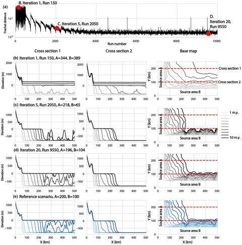
Delineating sediment source areas is critical for source-to-sink analysis and energy exploration because it can reveal sediment pathways and their associated reservoir rocks. We developed a methodology that integrates stratigraphic forward modelling and inversion analysis to provide a first-order provenance estimate. By employing a large number of modelling runs, and then applying a neighbourhood algorithm we are able to efficiently identify the best source-to-sink reconstruction(s). This methodology only requires shelf-margin records to calibrate the modelling results, therefore, it can be applied in frontier basins with relatively poor data coverage. We test this methodology on a synthetic example with predetermined parameters, and then apply it to deposits of the Colville Basin of northern Alaska, which is known for its remote location and high cost of data collection. The best-fit reconstructions from our modelling show that Cretaceous Colville Basin sediments deposited from 120 to 97 My were mainly sourced from the Herald Arch, Chukchi Platform, and western Brooks Range Orogenic Belt, consistent with the interpretations of previous provenance studies. The proposed method provides quantitative constraints for analysing deposits of large, remote, or ultra-deep basins, particularly those with sparse datasets or where sandstone detrital modes are largely unknown.
中文翻译:

整合地层建模,反演分析和架子裕度记录以指导物源分析:以北极阿拉斯加白垩纪科尔维尔盆地为例
划定沉积物源区对于进行源到汇分析和能源勘探至关重要,因为它可以揭示沉积物通道及其相关的储集岩。我们开发了一种方法,该方法整合了地层正演模型和反演分析以提供一阶物源估计。通过使用大量建模运行,然后应用邻域算法,我们能够有效地识别出最佳的源到汇重构。这种方法只需要货架裕量记录就可以校准建模结果,因此,它可以应用于数据覆盖率相对较差的边境盆地。我们在具有预定参数的综合示例中测试了该方法,然后将其应用于阿拉斯加北部科尔维尔盆地的矿床,它以其偏远的地理位置和高昂的数据收集成本而闻名。根据我们的模型进行的最合适的重建表明,从120 My到97 My的白垩纪科尔维尔盆地沉积物主要来自先驱弓,楚科奇平台和布鲁克斯造山带西部,与先前的物源研究的解释一致。所提出的方法为分析大型,偏远或超深盆地的沉积物提供了定量约束,特别是那些数据集稀疏或砂岩碎屑模式未知的盆地。与以前的来源研究的解释一致。所提出的方法为分析大型,偏远或超深盆地的沉积物提供了定量约束,特别是那些数据集稀疏或砂岩碎屑模式未知的盆地。与以前的来源研究的解释一致。所提出的方法为分析大型,偏远或超深盆地的沉积物提供了定量约束,特别是那些数据集稀疏或砂岩碎屑模式未知的盆地。
更新日期:2021-01-16
中文翻译:
整合地层建模,反演分析和架子裕度记录以指导物源分析:以北极阿拉斯加白垩纪科尔维尔盆地为例
划定沉积物源区对于进行源到汇分析和能源勘探至关重要,因为它可以揭示沉积物通道及其相关的储集岩。我们开发了一种方法,该方法整合了地层正演模型和反演分析以提供一阶物源估计。通过使用大量建模运行,然后应用邻域算法,我们能够有效地识别出最佳的源到汇重构。这种方法只需要货架裕量记录就可以校准建模结果,因此,它可以应用于数据覆盖率相对较差的边境盆地。我们在具有预定参数的综合示例中测试了该方法,然后将其应用于阿拉斯加北部科尔维尔盆地的矿床,它以其偏远的地理位置和高昂的数据收集成本而闻名。根据我们的模型进行的最合适的重建表明,从120 My到97 My的白垩纪科尔维尔盆地沉积物主要来自先驱弓,楚科奇平台和布鲁克斯造山带西部,与先前的物源研究的解释一致。所提出的方法为分析大型,偏远或超深盆地的沉积物提供了定量约束,特别是那些数据集稀疏或砂岩碎屑模式未知的盆地。与以前的来源研究的解释一致。所提出的方法为分析大型,偏远或超深盆地的沉积物提供了定量约束,特别是那些数据集稀疏或砂岩碎屑模式未知的盆地。与以前的来源研究的解释一致。所提出的方法为分析大型,偏远或超深盆地的沉积物提供了定量约束,特别是那些数据集稀疏或砂岩碎屑模式未知的盆地。


 京公网安备 11010802027423号