Applied Geography ( IF 4.0 ) Pub Date : 2021-01-16 , DOI: 10.1016/j.apgeog.2020.102379 Pedro R. Martins , Edson E. Sano , Eder S. Martins , Ludgero C.G. Vieira , Luiz F. Salemi , Vinicius Vasconcelos , Antônio F. Couto Júnior
|
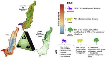
Integrity of most of tropical wetlands is threatened because they are often considered freely available resources of land and water. The Bananal, in the Araguaia River Basin, and the Pantanal in the Paraguai River Basin, are the two largest Brazilian wetlands influenced by the tropical seasonal floods. The purpose of this study is to integrate landscape structural and functional factors with the GPP dynamics over different terrain units present in the Araguaia River Basin. The study was conducted through the integration of different databases, including the topographic domains, protected areas and indigenous lands; land use and land cover map (year 2016); time series of GPP derived from the Moderate Resolution Imaging Spectroradiometer (MODIS) sensor (period of 2000–2015); Shuttle Radar Topography Mission (SRTM) digital elevation models (DEM); and precipitation data produced by the WorldClim version 2 dataset. GPP time series were processed using statistical methods of time series decomposition. The results show that, in the alluvial domains, we find grasslands (mostly), alluvial forests with the highest levels of GPP, and the largest legally protected areas. Spatial distribution of pasturelands across the entire basin is broad while croplands are concentrated mainly in geologically old and high plateaus. The time series analysis revealed the presence of intra- and inter-annual vegetation patterns and a continuous increase of GPP over time. The results contribute to the understanding of the linkages between land use changes and global carbon cycles by considering land use as a response of how the landscape is organized. The results may provide subsidies for public policies for the carbon budget equilibrium, conservation of biodiversity, and rational use of natural resources.
中文翻译:
巴西亚马孙/塞拉多过渡带最大的河流盆地的地形单位,土地利用和土地覆盖以及总初级生产力:Araguaia流域
大多数热带湿地的完整性受到威胁,因为它们通常被视为可自由获得的土地和水源。受热带季节性洪水影响,位于阿拉瓜河流域的巴纳纳尔河和位于巴拉圭河流域的潘塔纳尔河是巴西最大的两个湿地。这项研究的目的是将景观结构和功能因素与阿拉瓜河流域不同地形单元上的GPP动态结合起来。这项研究是通过整合各种数据库进行的,包括地形域,保护区和土著土地;土地使用和土地覆盖图(2016年);从中分辨率成像光谱仪(MODIS)传感器得出的GPP时间序列(2000-2015年);穿梭雷达地形任务(SRTM)数字高程模型(DEM);和WorldClim版本2数据集产生的降水数据。使用时间序列分解的统计方法处理GPP时间序列。结果表明,在冲积层中,我们发现了草原(主要是草地),GPP最高的冲积林和最大的法律保护区。整个流域的牧场空间分布广泛,而耕地则主要集中在地质古老和高原地区。时间序列分析揭示了年内和年际植被格局的存在以及GPP随时间的持续增加。通过将土地利用视为景观的组织方式,结果有助于了解土地利用变化与全球碳循环之间的联系。


 京公网安备 11010802027423号