Journal of Visualization ( IF 1.7 ) Pub Date : 2021-01-16 , DOI: 10.1007/s12650-020-00713-3 Liyan Liu , Hongxin Zhang , Jiaxin Liu , Shangching Liu , Wei Chen , Jiaju Man
|
Abstract
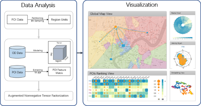
A city contains a variety of different urban functions with referring to the purpose of land use to support the diverse needs of urban residents, such as residence, working and recreation. Exploring urban functional zones is a critical task, which provides valuable applications for business site selection, transportation management and urban planning. It is well known that location information and human mobility semantics both are significant factors for identifying urban functional zones, just considering one factor is not effective. However, most of existing techniques capture the transformation of functional zones and interpret the results based solely on location or mobility semantics, and lack the capacity to deal with the multifaceted features of urban data. To tackle these problems, in this paper, we propose an interactive visual analytics system for effectively exploring urban functional zones based on spatio-temporal OD data and Points of Interest data. We first adaptively partition the territory into region units based on adaptive blue noise sampling method, extract POI feature matrix (location information) as a prior knowledge, model multidimensional spatio-temporal OD data as a tensor for addressing multifaceted features and propose an augment tensor-based algorithm that enables users to simultaneously combine mobility semantics and inherent location information for identifying functional zones. In addition, we design a set of visual encodings to better understand and interpret the results in a visual and intuitive manner. This system has been demonstrated using two case studies with a real-world dataset of HangZhou city and domain-expert interviews.
Graphic Abstract
中文翻译:
基于增强非负张量因子分解的城市功能区视觉探索
摘要
一个城市包含各种不同的城市功能,它们涉及土地用途以支持城市居民的各种需求,例如居住,工作和娱乐。探索城市功能区是一项至关重要的任务,它为企业选址,交通管理和城市规划提供了有价值的应用程序。众所周知,位置信息和人员流动语义都是识别城市功能区的重要因素,仅考虑一个因素是无效的。但是,大多数现有技术只能捕获功能区的转换并仅根据位置或移动语义来解释结果,并且缺乏处理城市数据多方面特征的能力。为了解决这些问题,在本文中,我们提出了一种交互式视觉分析系统,可以基于时空OD数据和兴趣点数据有效地探索城市功能区。我们首先根据自适应蓝噪声采样方法将区域自适应地划分为区域单位,提取POI特征矩阵(位置信息)作为先验知识,将多维时空OD数据建模为用于处理多面特征的张量,并提出增强张量-基于算法的算法,使用户能够同时结合移动性语义和固有位置信息以识别功能区。此外,我们设计了一组视觉编码,以直观,直观的方式更好地理解和解释结果。


 京公网安备 11010802027423号