Journal of Hydrology ( IF 5.9 ) Pub Date : 2021-01-12 , DOI: 10.1016/j.jhydrol.2021.125965 Andy Baker , Mirjam Scheller , Fabio Oriani , Grégoire Mariéthoz , Andreas Hartmann , Zhangyong Wang , Mark Cuthbert
|
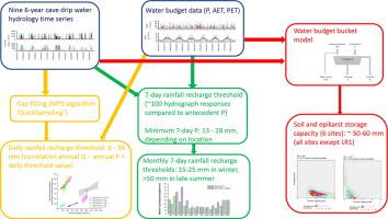
Quantifying rainfall recharge thresholds, including their spatial and temporal heterogeneity, is of fundamental importance to better understand recharge processes and improving estimation of recharge rates. Caves provide a unique observatory into the percolation of water from the surface to the water table at the timescale of individual rainfall recharge events. Here, we monitor nine infiltration sites over six years at a montane cave site in south eastern Australia. Six of the drip hydrology time series have up to ∼100 hydrograph responses to rainfall over the monitoring period, three sites do not respond to rainfall events. We use two approaches to quantify rainfall recharge thresholds. At an annual timescale, for all nine drip sites, the total annual percolation water volume was determined for each year of data. Daily rainfall recharge thresholds were then determined by maximising the correlation of annual percolation water volume and total precipitation above a variable daily threshold value. The annual recharge amount methodology produced rainfall recharge thresholds for seven sites, where high and significant correlations (rank correlations > 0.75) occur for daily precipitation thresholds between 6 mm and 38 mm / day. No rainfall recharge thresholds could be obtained from one site which had a low and constant annual drip amount, and from one site which exhibited ‘underflow’ behaviour. At an event timescale, for the six sites which had a hydrograph response to rainfall, the 7-day antecedent rainfall amounts were determined. Minimum 7-day precipitation amounts prior to a hydrograph response for specific drip sites were in the range 13 – 28 mm and 75% of all recharge events had a 7-day antecedent precipitation between 20.7 and 38.1 mm. Combining all drip water monitoring sites and analysing the data by month identifies a seasonal variability in the minimum 7-day antecedent precipitation necessary to generate potential recharge, from 15-25 mm in winter to >50 mm in February and March. We apply a simple water budget model, driven by P and ET and optimised to the observed potential recharge events, to infer a ‘whole cave’ soil and epikarst storage capacity. This storage capacity is between ∼50 mm (using potential evapotranspiration, 92% of events simulated successfully) to ∼60 mm (using actual evapotranspiration, 79% of events simulated successfully). Modelling of individual drip sites identifies spatial heterogeneity in soil and epikarst storage capacities. Our approach using multiple methodologies allows the comparison between both daily and weekly rainfall recharge thresholds and modelled soil and epikarst storage for the first time.
中文翻译:
定量评估山区喀斯特环境中降雨补给阈值的时间变异性和空间异质性
量化降雨补给阈值(包括其空间和时间异质性)对于更好地了解补给过程和改善补给率估算至关重要。洞穴为每个降雨补给事件的时间尺度上的水从地表渗入地下水提供了独特的观测平台。在这里,我们在6年内在澳大利亚东南部的山洞地区监测了9个渗透点。在监测期内,六个滴灌水文时间序列对降水的水文响应高达〜100个,三个站点对降雨事件无响应。我们使用两种方法来量化降雨补给阈值。在每年的时间尺度上,对于所有九个滴水点,每年的数据都确定了总的年度渗滤水量。然后,通过使年度渗滤水量与总日降水量高于可变日阈值的相关性最大化,来确定日降水补给阈值。年度补给量方法得出了七个地点的降雨补给阈值,其中每日降水阈值介于6毫米至38毫米/天之间存在高和显着的相关性(秩相关> 0.75)。不能从一个年滴水量低且恒定的站点和一个表现出“下溢”行为的站点获得降雨补给阈值。在一个事件时间尺度上,对于六个对降雨有水文响应的站点,确定了7天的前降雨量。在针对特定滴水点的水文响应之前,最少7天的降水量在13-28毫米范围内,所有补给事件的75%前7天的降水量在20.7至38.1毫米之间。结合所有滴水监测站点并按月分析数据,可以确定产生潜在补给所必需的至少7天前期降水的季节变化,从冬季的15-25毫米到2月和3月的> 50毫米。我们应用了一个简单的水预算模型,该模型由P和ET驱动,并针对观察到的潜在补给事件进行了优化,以推断出“整个洞穴”的土壤和表层岩溶的存储能力。此存储容量在〜50 mm(使用潜在的蒸散量,成功模拟的事件的92%)到〜60 mm(使用实际的蒸散量,成功模拟的事件的79%)之间。对单个滴灌点进行建模可确定土壤和表岩溶储量的空间异质性。我们采用多种方法的方法首次可以比较每日和每周的降雨补给阈值以及模拟的土壤和表层岩溶储量。


 京公网安备 11010802027423号