当前位置:
X-MOL 学术
›
Geoarchaeology
›
论文详情
Our official English website, www.x-mol.net, welcomes your
feedback! (Note: you will need to create a separate account there.)
Spatial and temporal variability in geomorphic change at tidally influenced shipwreck sites: The use of time‐lapse multibeam data for the assessment of site formation processes
Geoarchaeology ( IF 1.4 ) Pub Date : 2021-01-09 , DOI: 10.1002/gea.21840 Jan Majcher 1 , Rory Quinn 1 , Ruth Plets 1, 2 , Mark Coughlan 3, 4 , Christopher McGonigle 1 , Fabio Sacchetti 5 , Kieran Westley 1
Geoarchaeology ( IF 1.4 ) Pub Date : 2021-01-09 , DOI: 10.1002/gea.21840 Jan Majcher 1 , Rory Quinn 1 , Ruth Plets 1, 2 , Mark Coughlan 3, 4 , Christopher McGonigle 1 , Fabio Sacchetti 5 , Kieran Westley 1
Affiliation
|
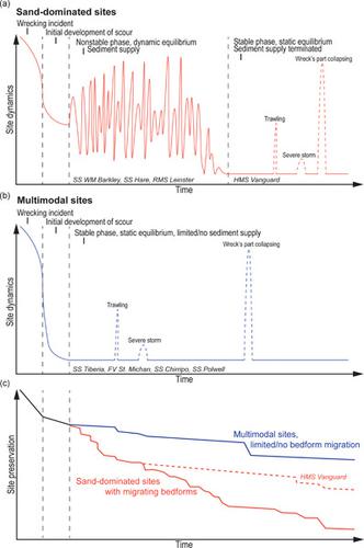
Shipwrecks are an integral part of our maritime archaeological landscape and are associated with diverse societal and cultural interests, yielding significant management challenges. Coupled hydrodynamic and geomorphological processes significantly impact the effective in situ preservation of these fragile sites. In this study, we assess sediment budget change and hydrodynamic triggers at metal‐hulled shipwrecks lost between 1875 and 1918, all located in the tidally dominated Irish Sea at depths between 26 and 84 m. This is conducted using time‐lapse, multibeam echosounder surveys at multiannual, annual, and weekly time steps, supported by sediment grain‐size analysis, modeled ocean currents, and shallow seismic data. Results indicate significant changes at all time steps for sites located in sand‐dominated environments, whereas the seabed around shipwrecks settled in multimodal sediments shows virtually no change outside of measurement errors (±30 cm). Variability in geomorphic change is attributed to local environmental factors, including bed shear stress, sediment supply, and spatial barriers to scour. We demonstrate that individual wrecks in similar shelf sea regions can be in very different equilibrium states, which has critical implications for the in situ management of underwater cultural heritage.
中文翻译:

受潮汐影响的沉船地点的地貌变化的时空变化:时移多波束数据在场地形成过程评估中的应用
沉船是我们海洋考古景观不可或缺的一部分,与各种各样的社会和文化利益相关联,带来了重大的管理挑战。耦合的水动力和地貌过程极大地影响了这些脆弱地点的有效原地保存。在这项研究中,我们评估了位于1875年至1918年之间丢失的金属壳沉船的沉积物预算变化和水动力触发因素,这些沉船全部位于潮汐主导的爱尔兰海中,深度在26至84 m之间。这是通过在每年,每年和每周的时间步长进行时移,多波束回波调查进行的,并得到沉积物粒度分析,模拟洋流和浅层地震数据的支持。结果表明,位于沙地环境中的站点在所有时间段都发生了重大变化,而沉船周围的海床沉积在多峰沉积物中,除测量误差(±30厘米)外,几乎没有变化。地貌变化的可变性归因于当地的环境因素,包括河床剪切应力,沉积物供应和冲刷的空间障碍。我们证明,在相似的架子海区域内的个体残骸可能处于非常不同的平衡状态,这对水下文化遗产的就地管理具有至关重要的意义。
更新日期:2021-01-09
中文翻译:
受潮汐影响的沉船地点的地貌变化的时空变化:时移多波束数据在场地形成过程评估中的应用
沉船是我们海洋考古景观不可或缺的一部分,与各种各样的社会和文化利益相关联,带来了重大的管理挑战。耦合的水动力和地貌过程极大地影响了这些脆弱地点的有效原地保存。在这项研究中,我们评估了位于1875年至1918年之间丢失的金属壳沉船的沉积物预算变化和水动力触发因素,这些沉船全部位于潮汐主导的爱尔兰海中,深度在26至84 m之间。这是通过在每年,每年和每周的时间步长进行时移,多波束回波调查进行的,并得到沉积物粒度分析,模拟洋流和浅层地震数据的支持。结果表明,位于沙地环境中的站点在所有时间段都发生了重大变化,而沉船周围的海床沉积在多峰沉积物中,除测量误差(±30厘米)外,几乎没有变化。地貌变化的可变性归因于当地的环境因素,包括河床剪切应力,沉积物供应和冲刷的空间障碍。我们证明,在相似的架子海区域内的个体残骸可能处于非常不同的平衡状态,这对水下文化遗产的就地管理具有至关重要的意义。


 京公网安备 11010802027423号