Progress in Earth and Planetary Science ( IF 3.5 ) Pub Date : 2021-01-06 , DOI: 10.1186/s40645-020-00386-4 Kodai Yamamoto , Takahiro Sayama , Apip
|
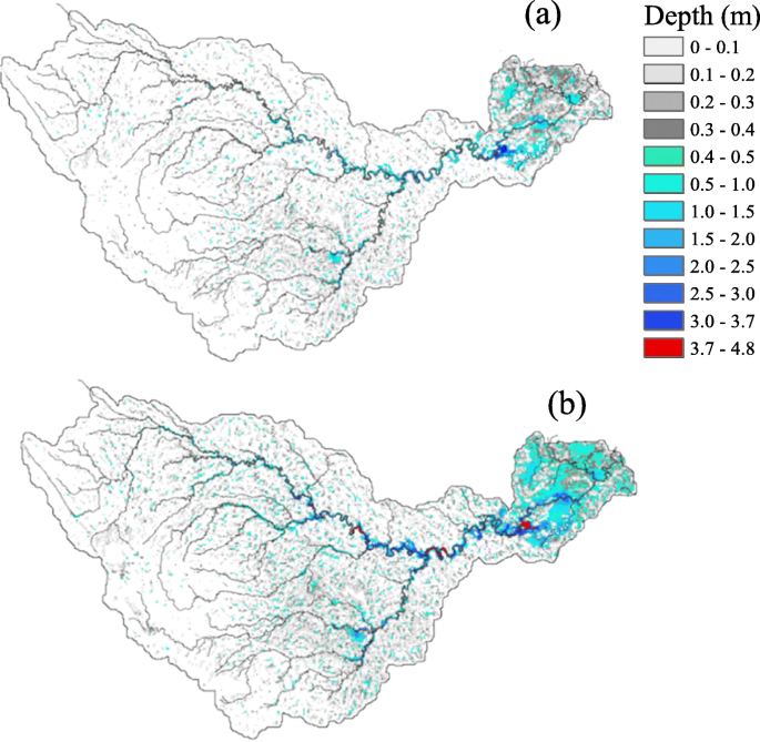
Climate change will have a significant impact on the water cycle and will lead to severe environmental problems and disasters in humid tropical river basins. Examples include river basins in Sumatra Island, Indonesia, where the coastal lowland areas are mostly composed of peatland that is a wetland environment initially sustained by flooding from rivers. Climate change may alter the frequency and magnitude of flood inundation in these lowland areas, disturbing the peatland environment and its carbon dynamics and damaging agricultural plantations. Consequently, projecting the extent of inundation due to future flooding events is considered important for river basin management. Using dynamically downscaled climate data obtained by the Non-Hydrostatic Regional Climate Model (NHRCM), the Rainfall-Runoff-Inundation (RRI) model was applied to the Batanghari River Basin (42,960 km2) in Sumatra Island, Indonesia, to project the extent of flood inundation in the latter part of the twenty-first century. In order to obtain reasonable estimates of the extent of future flood inundation, this study compared two bias correction methods: a Quantile Mapping (QM) method and a combination of QM and Variance Scaling (VS) methods. The results showed that the bias correction obtained by the QM method improved the simulated flow duration curve (FDC) obtained from the RRI model, which facilitated comparison with the simulated FDC using reference rainfall data. However, the high spatial variability observed in daily and 15-day rainfall data remained as the spatial variation bias, and this could not be resolved by simple QM bias correction alone. Consequently, the simulated extreme variables, such as annual maximum flood inundation volume, were overestimated compared to the reference data. By introducing QM-VS bias correction, the cumulative density functions of annual maximum discharge and inundation volumes were improved. The findings also showed that flooding will increase in this region; for example, the flood inundation volume corresponding to a 20-year return period will increase by 3.3 times. River basin management measures, such as land use regulations for plantations and wetland conservation, should therefore consider increases in flood depth and area, the extents of which under a future climate scenario are presented in this study.
中文翻译:
气候变化对印度尼西亚热带河流域洪水泛滥的影响
气候变化将对水循环产生重大影响,并导致严重的环境问题和潮湿热带河流域的灾害。例子包括印度尼西亚苏门答腊岛的流域,那里的沿海低地地区主要由泥炭地组成,而泥炭地最初是由河流洪水造成的湿地环境。气候变化可能会改变这些低地地区洪水泛滥的频率和程度,扰乱泥炭地环境及其碳动态,并破坏农业种植园。因此,对未来洪水事件造成的淹没程度进行预测对流域管理很重要。使用通过非静水区域气候模型(NHRCM)获得的动态缩减的气候数据,2)在印度尼西亚苏门答腊岛,以预测二十一世纪后期洪水泛滥的程度。为了获得对未来洪水泛滥程度的合理估计,本研究比较了两种偏差校正方法:分位数映射(QM)方法以及QM和方差缩放(VS)方法的组合。结果表明,通过QM方法获得的偏差校正改善了从RRI模型获得的模拟流动持续时间曲线(FDC),从而有助于与使用参考降雨数据的模拟FDC进行比较。但是,在每日和15天降雨数据中观察到的高空间变异性仍然是空间变异偏差,而仅靠简单的QM偏差校正无法解决。因此,模拟的极端变量,例如年度最大洪水淹没量,与参考数据相比被高估了。通过引入QM-VS偏差校正,改善了年度最大流量和淹没量的累积密度函数。研究结果还表明,该地区的洪水将增加。例如,对应于20年恢复期的洪水淹没量将增加3.3倍。因此,流域管理措施,例如用于人工林和湿地保护的土地使用法规,应考虑洪水深度和面积的增加,本研究提出了在未来气候情景下的程度。研究结果还表明,该地区的洪水将增加。例如,对应于20年恢复期的洪水淹没量将增加3.3倍。因此,流域管理措施,例如用于人工林和湿地保护的土地使用法规,应考虑洪水深度和面积的增加,本研究提出了在未来气候情景下的程度。研究结果还表明,该地区的洪水将增加。例如,对应于20年恢复期的洪水淹没量将增加3.3倍。因此,流域管理措施,例如用于人工林和湿地保护的土地使用法规,应考虑洪水深度和面积的增加,本研究提出了在未来气候情景下的程度。


 京公网安备 11010802027423号