Progress in Earth and Planetary Science ( IF 3.5 ) Pub Date : 2021-01-05 , DOI: 10.1186/s40645-020-00398-0 Junko Iwahashi , Dai Yamazaki , Takayuki Nakano , Ryo Endo
|
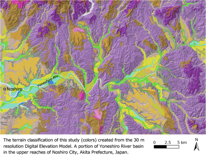
This study aims to create a terrain classification of Japan that allows both geomorphological and geoengineering classifications coexist without large contradictions and to distinguish landform elements even in urban plains which include noise associated with digital elevation models (DEMs). Because Japan is susceptible to natural disasters, we designed the classification to reflect the ground vulnerability of both alluvial plains and mountains through the application of terrain classification data to landslide susceptibility and seismic zoning. We updated an existing DEM-based terrain classification method for application in the high-resolution 30 m DEM. We used topographic measurements that do not amplify manmade unevenness or noise, which are usually the main problems associated with the use of high-resolution DEMs with high vertical accuracies. We selected the height above the nearest drainage (HAND), slope gradient, surface texture, and local convexity as geometric signatures, which were devised so as not to detect noise. Segment polygon data of terrain units were derived from the raster data of slope and HAND. The polygon data were classified into 40 clusters using the attributes of slope, HAND, and surface texture; then they were grouped into 16 legends following comparisons with the existing geological and geomorphological maps and supplementary reclassification by HAND and local convexity. The derived terrain classification, except for manmade cuts and fills, showed similarities with the existing expert-driven maps and some association with areas where shallow landslides or floods frequently occur. Based on a trial in California using a 30 m DEM, we concluded that the proposed method can be adopted in other regions outside of Japan.
中文翻译:
使用30 m DEM对日本冲积平原和山区进行地面脆弱性评估的地形分类
这项研究旨在创建一个日本的地形分类,该分类允许地理形态分类和地球工程分类并存而没有大的矛盾,并且即使在包括与数字高程模型(DEM)相关的噪声的城市平原中,也可以区分地形要素。由于日本易受自然灾害的影响,我们通过将地形分类数据应用于滑坡敏感性和地震分区,设计了分类方法,以反映冲积平原和山区的地面脆弱性。我们更新了现有的基于DEM的地形分类方法,以用于高分辨率30 m DEM。我们使用的地形测量不会放大人为的不均匀性或噪声,而这些通常是与使用具有高垂直精度的高分辨率DEM相关的主要问题。我们选择了最近排水(HAND)上方的高度,坡度,表面纹理和局部凸度作为几何特征,其设计目的是不检测噪声。地形单位的分段多边形数据是从坡度和手的栅格数据导出的。使用坡度,HAND和表面纹理的属性将多边形数据分为40个类;然后将它们与现有的地质和地貌图进行比较,并通过HAND和局部凸度进行补充重新分类,从而将它们分为16个图例。除人工挖挖和填土外,得出的地形分类与现有的专家驱动的地图相似,并且与经常发生浅层滑坡或洪水的区域有关。根据在加利福尼亚使用30 m DEM进行的试验,


 京公网安备 11010802027423号