Catena ( IF 5.4 ) Pub Date : 2021-01-04 , DOI: 10.1016/j.catena.2020.105109 Alla Yu Yurova , Maria A. Smirnova , Nickolay I. Lozbenev , Pavel P. Fil , Daniil N. Kozlov
|
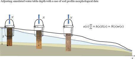
Mapping soil properties has obvious utility for formulating agricultural management regimes. One that is particularly pertinent in areas with shallow water tables in semiarid regions, especially where catchments have both dry and moist parts, is hydromorphy degree. However, there is no convenient method for converting it to hydrological model state variables, which is a crucial first step for mapping (in the absence of extremely thorough and costly monitoring). Here we propose that the steady state continuity equation in kinematic wave form can be parameterized using expert knowledge of the typical water table depth (WTD) for soils with different hydromorphy degrees. To test the approach, six hillslope-based computational units (catenas) were obtained, for use in simulations, by automated of the Samovetc and Izberdey catchments in the Tambov region (Russia) using lumpR software. Five of the six catenas began at poorly drained flat upslope positions with soils with various degrees of saturation by shallow groundwater and one began at a well-drained upslope position. Each of the six hillslopes had a unique catenary sequence of soils, but each represented a typical unit. We genetically classified soils in the sequences according to hydromorphy degree based on redoximorphic features as diagnostic properties. For each resulting group, a historical database summarizing possible positions of the WTD was used. Application of expert knowledge in this manner alone yielded a broad range of possible WTD values (e.g. 1.5–5 m for a semi-hydromorphic soil) for each soil entity, but linking a catena by the fundamental physical constraint of flow continuity enabled narrowing of the range to 0.2–1 m thereby reducing it by ca. 80%. The results show that the approach could substantially improve crop and water management precision.
中文翻译:
利用土壤水分变形度调整半干旱俄罗斯沿连绵山脉的稳态地下水位模拟
绘制土壤特性图对于制定农业管理制度具有明显的实用性。在半干旱地区地下水位较浅的地区,特别是在集水区既有干燥部分又有潮湿部分的地区,特别重要的是水形度。但是,没有简便的方法可以将其转换为水文模型状态变量,这是进行映射的关键的第一步(在缺乏非常彻底且昂贵的监视的情况下)。在这里,我们建议可以使用专家知识,对具有不同水变形度的土壤的典型地下水位深度(WTD)进行运动波形形式的稳态连续性方程式参数化。为了测试该方法,获得了六个基于坡度的计算单元(类别),用于模拟,通过使用lumpR软件对坦波夫地区(俄罗斯)的Samovetc和Izberdey集水区进行自动化。六个链中的五个开始于排水不畅的平坦上坡位置,土壤被浅层地下水饱和程度不同,其中一个开始于排水良好的上坡位置。六个山坡中的每一个都有一个独特的悬链线土壤,但是每个代表一个典型的单位。我们基于氧化还原型特征作为诊断特性,根据水形程度对序列中的土壤进行了遗传分类。对于每个结果组,都使用历史数据库来汇总WTD的可能位置。仅以这种方式应用专家知识就可以为每个土壤实体提供广泛的WTD值范围(例如,半亲水性土壤为1.5–5 m),但是,通过连续流动的基本物理约束将链环连接起来,可以将范围缩小到0.2-1 m,从而将其减小约ca。80%。结果表明,该方法可以大大提高作物和水管理的精度。


 京公网安备 11010802027423号