Bulletin of Engineering Geology and the Environment ( IF 3.7 ) Pub Date : 2021-01-02 , DOI: 10.1007/s10064-020-02053-w M. Paula Bunicontro , Silvia C. Marcomini , Rubén A. López
|
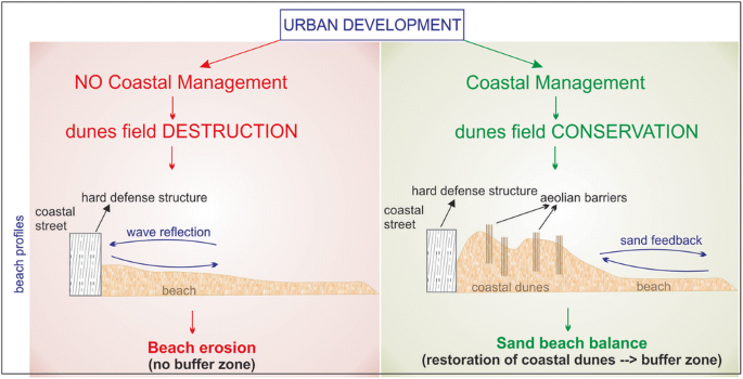
Puerto Madryn city (Chubut province, Argentina) has strongly increased its population since 1970, but a lack of coastal management strategies has favored physical changes in the natural landscape. This situation has led to a deficit in sediment supply sources, which increases beach erosion susceptibility.
This paper aims to evaluate beach erosion susceptibility through the use of geo-indicators. It also provides a susceptibility map based on geomorphological evidence and the weighting of physical geo-indicators. The final objective is to propose soft solutions that consider a comprehensive coastal management. The main anthropogenic disturbances identified were beach cleaning with bulldozer, coastal armoring, removal of dune fields (about 90% between 1942 and 2019), foredune segmentation, installation of resorts on backshore, and artificial rainfall drains towards the beach. The natural and most sensitive geo-indicators affected by human pressure—and thus the most useful for determining susceptibility—were foredune conservation and width, and backshore width. We estimate a high to moderate susceptibility to beach erosion along the coast of Puerto Madryn. As regards management policies, we propose mainly restoration, prevention, and adaptation strategies, such as the use of sand fences and new techniques for beach cleaning, all of which are aimed at promoting sedimentary balance within the dune-beach system. Besides these procedures, we recommend the consideration of preventive actions, such as a future-oriented urban planning and a program to raise popular awareness of coastal problems. The diagnostic approach based on a geo-indicator survey has provided a useful tool to help decision-making in coastal conservation initiatives.
Graphical abstract
中文翻译:
基于地理指标和软管理政策的海滩侵蚀敏感性评估:巴塔哥尼亚案例研究(阿根廷)
自1970年以来,马德林港市(阿根廷丘布特省)的人口就大大增加了,但是缺乏沿海管理策略却有利于自然景观的自然变化。这种情况导致了沉积物供应源的短缺,从而增加了海滩侵蚀的敏感性。
本文旨在通过使用地理指标来评估海滩侵蚀的敏感性。它还提供了基于地貌证据和物理地理指示符权重的磁化率图。最终目标是提出考虑全面沿海管理的软解决方案。确定的主要人为干扰因素是用推土机清洁海滩,沿海装甲,清除沙丘田地(1942年至2019年约占90%),山丘分割,沿岸度假村的安装以及向海滩的人工降雨。受人类压力影响的自然和最敏感的地理指示符(因此也是确定敏感性的最有用的指示符)是前陆保护区和宽度以及后岸宽度。我们估计波多黎各马德林沿岸对海滩侵蚀的敏感性高到中度。关于管理政策,我们主要提出恢复,预防和适应策略,例如使用防沙栅栏和清洁海滩的新技术,所有这些旨在促进沙丘-海滩系统内的沉积物平衡。除了这些程序外,我们还建议考虑采取预防措施,例如面向未来的城市规划和提高民众对沿海问题意识的计划。基于地理指标调查的诊断方法提供了有用的工具,可帮助制定沿海保护措施的决策。所有这些旨在促进沙丘-海滩系统内的沉积物平衡。除了这些程序外,我们还建议考虑采取预防措施,例如面向未来的城市规划和提高民众对沿海问题意识的计划。基于地理指标调查的诊断方法提供了有用的工具,可帮助制定沿海保护措施的决策。所有这些旨在促进沙丘-海滩系统内的沉积物平衡。除了这些程序外,我们还建议考虑采取预防措施,例如面向未来的城市规划和提高民众对沿海问题意识的计划。基于地理指标调查的诊断方法提供了有用的工具,可帮助制定沿海保护措施的决策。


 京公网安备 11010802027423号