当前位置:
X-MOL 学术
›
Ecol. Res.
›
论文详情
Our official English website, www.x-mol.net, welcomes your
feedback! (Note: you will need to create a separate account there.)
Comparison of vegetation patch dynamics after the eruptions of the volcano Mount Usu, northern Japan, in 1977–1978 and 2000, detected by imagery chronosequence
Ecological Research ( IF 1.7 ) Pub Date : 2020-12-29 , DOI: 10.1111/1440-1703.12199 Lea Végh 1 , Shiro Tsuyuzaki 1
Ecological Research ( IF 1.7 ) Pub Date : 2020-12-29 , DOI: 10.1111/1440-1703.12199 Lea Végh 1 , Shiro Tsuyuzaki 1
Affiliation
|
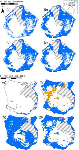
Vegetation patch dynamics were analyzed to detect vegetation development patterns after eruptions on two sites (summit destroyed in 1977–1978, and a foothill, Konpira destroyed in 2000) on the volcano Mount Usu, in northern Japan. Aerial photos and satellite images taken in 2000, 2006, and 2014 were used to develop an imagery chronosequence of vegetation patch dynamics. Vegetation patches were identified by the Normalized Difference Vegetation Index (NDVI) for satellite images, and by the Normalized Green‐Red Difference Index (NGRDI) for aerial photos. We categorized the vegetation patch types based on whether the patches overlapped (touching) or not (isolated) with the future vegetation patches and whether their area increased (growing) or decreased (shrinking). Afterwards, patch dynamics were compared between the two sites through changes in patch types, dense vegetation, and patch growth with slope degree, elevation, and time. Isolated patches were established more at the summit and showed high mortality, while at Konpira most isolated patches survived until 2006 and merged into touching patches by 2014. Moreover, the vegetation density of patches was higher at Konpira than at the summit. Patch growth was associated with patch types at both sites. However, the time was more important for the patch dynamics at the summit, and the vegetation density affected the dynamics more at Konpira. Therefore, the two sites had different vegetation patch dynamics, which were related to the characteristics of topography and eruptions. In conclusion, the imagery chronosequence proposed in this study monitored patch dynamics well, and patches developed faster at Konpira.
中文翻译:

通过图像时间序列对日本北部乌苏山火山爆发后1977–1978年和2000年后的植被斑块动态进行比较
在日本北部的火山山上,对植被斑块动力学进行了分析,以检测出两个地点喷发后的植被发育模式(顶峰在1977年至1978年被破坏,山麓丘比拉在2000年被破坏)。利用2000年,2006年和2014年拍摄的航拍照片和卫星图像来绘制植被斑块动态的影像时序。植被斑块通过卫星图像的归一化差异植被指数(NDVI)进行标识,而航空照片则通过归一化绿色-红色差异指数(NGRDI)进行标识。我们根据斑块的类型是否与未来的斑块重叠(接触)(不孤立)以及它们的面积是增加(增长)还是减少(缩小)来对植被斑块类型进行分类。然后,通过斑块类型,茂密植被和斑块生长随坡度,海拔和时间的变化,比较了两个地点的斑块动力学。在山顶建立更多孤立的斑块,并显示出高死亡率,而在Konpira,大多数孤立的斑块存活到2006年,到2014年合并为接触斑块。此外,Kompira的斑块植被密度高于山顶。补丁的增长与两个站点的补丁类型有关。然而,时间对于山顶的斑块动态更为重要,而植被密度对Konpira的动态影响更大。因此,这两个地点的植被斑块动态不同,这与地形和喷发特征有关。总而言之,这项研究中提出的影像时间序列很好地监测了斑块动态,
更新日期:2020-12-29
中文翻译:
通过图像时间序列对日本北部乌苏山火山爆发后1977–1978年和2000年后的植被斑块动态进行比较
在日本北部的火山山上,对植被斑块动力学进行了分析,以检测出两个地点喷发后的植被发育模式(顶峰在1977年至1978年被破坏,山麓丘比拉在2000年被破坏)。利用2000年,2006年和2014年拍摄的航拍照片和卫星图像来绘制植被斑块动态的影像时序。植被斑块通过卫星图像的归一化差异植被指数(NDVI)进行标识,而航空照片则通过归一化绿色-红色差异指数(NGRDI)进行标识。我们根据斑块的类型是否与未来的斑块重叠(接触)(不孤立)以及它们的面积是增加(增长)还是减少(缩小)来对植被斑块类型进行分类。然后,通过斑块类型,茂密植被和斑块生长随坡度,海拔和时间的变化,比较了两个地点的斑块动力学。在山顶建立更多孤立的斑块,并显示出高死亡率,而在Konpira,大多数孤立的斑块存活到2006年,到2014年合并为接触斑块。此外,Kompira的斑块植被密度高于山顶。补丁的增长与两个站点的补丁类型有关。然而,时间对于山顶的斑块动态更为重要,而植被密度对Konpira的动态影响更大。因此,这两个地点的植被斑块动态不同,这与地形和喷发特征有关。总而言之,这项研究中提出的影像时间序列很好地监测了斑块动态,


 京公网安备 11010802027423号