当前位置:
X-MOL 学术
›
Int. J. Climatol.
›
论文详情
Our official English website, www.x-mol.net, welcomes your
feedback! (Note: you will need to create a separate account there.)
Spatial and temporal variability of rainfall over the Republic of Djibouti from 1946 to 2017
International Journal of Climatology ( IF 3.5 ) Pub Date : 2020-12-25 , DOI: 10.1002/joc.6986 Omar Assowe Dabar 1 , Pierre Camberlin 2 , Benjamin Pohl 2 , Moussa Mohamed Waberi 1 , Mohamed Osman Awaleh 1 , Sajed Silah‐Eddine 1
International Journal of Climatology ( IF 3.5 ) Pub Date : 2020-12-25 , DOI: 10.1002/joc.6986 Omar Assowe Dabar 1 , Pierre Camberlin 2 , Benjamin Pohl 2 , Moussa Mohamed Waberi 1 , Mohamed Osman Awaleh 1 , Sajed Silah‐Eddine 1
Affiliation
|
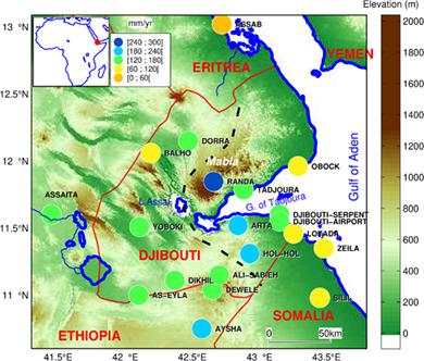
For the first time, the spatial and temporal variability of rainfall in the Republic of Djibouti is investigated using data from 14 weather stations over the period 1946–2017. Due to limited data availability, high‐resolution long‐term satellite rainfall products (CHIRPS, PERSIANN‐CDR, TAMSATv3, ARC2) and ERA5 reanalysis also contribute to document time–space rainfall variability at monthly, seasonal and annual scales. Principal component analysis identifies two spatially coherent regions of rainfall variability in the east (coastal zone) and the west (inland zone) of the country. Annual rainfall amounts are everywhere very low (60–300 mm), but with contrasted regimes. At seasonal scale, the highest rainfall amounts in the eastern part of the country are found between October–December (OND) and March–May (MAM), while July–September is the wettest season in the western part. The monthly rainfall regimes are relatively well reproduced by most products. ERA5 displays the highest monthly correlations with observations, followed by PERSIANN‐CDR and CHIRPS. Trend analysis since 1983 shows a significant decrease of rainfall during MAM which is in agreement with other parts of East Africa. On the other hand, nonsignificant decreasing trends are observed in January–February (JF) and OND. Only June–September (JJAS) revealed a nonsignificant increasing trend, but it follows a prior drying trend since the 1950s. The impact of large‐scale background climate on rainfall variability is assessed with focus given on El Niño Southern Oscillation (ENSO) and the Indian Ocean Dipole (IOD). Rainfall variability during OND shows a significant correlation with IOD, while in JJAS it is significantly negatively correlated with ENSO. In general, ERA5, CHIRPS and PERSIANN datasets are best able to reproduce rainfall patterns in Djibouti and suitable for further analysis. The fact that the interannual and decadal‐scale rainfall variations in Djibouti show large‐scale teleconnections with global sea‐surface temperature fields, as demonstrated in this study, provides good prospects for the prediction of rainfall variations at a range of different temporal scales.
中文翻译:

1946年至2017年吉布提共和国降雨的时空变化
吉布提共和国的降雨量的时空变化首次使用1946-2017年期间14个气象站的数据进行了调查。由于数据可用性有限,高分辨率长期卫星降水产品(CHIRPS,PERSIANN-CDR,TAMSATv3,ARC2)和ERA5重新分析也有助于记录月度,季节和年度尺度的时空降雨变化。主成分分析确定了该国东部(沿海地区)和西部(内陆地区)降雨变化的两个空间相关区域。各地的年降雨量都很低(60-300毫米),但情况却相反。在季节性范围内,该国东部地区的降雨量最高,发生在10月至12月(OND)至3月至5月(MAM)之间,7月至9月是西部最潮湿的季节。大多数产品都很好地再现了每月的降雨状况。ERA5显示与观测值的最高每月相关性,其次是PERSIANN-CDR和CHIRPS。自1983年以来的趋势分析表明,MAM期间的降雨显着减少,这与东非其他地区一致。另一方面,在1月至2月(JF)和OND观察到了不显着的下降趋势。仅6月至9月(JJAS)的增长趋势没有明显变化,但遵循自1950年代以来的先前干旱趋势。以厄尔尼诺南方涛动(ENSO)和印度洋偶极子(IOD)为重点,评估了大规模背景气候对降雨变化的影响。OND期间的降雨变化与IOD呈显着相关,而在JJAS中,它与ENSO显着负相关。一般而言,ERA5,CHIRPS和PERSIANN数据集最能再现吉布提的降雨模式,并适合进一步分析。如本研究所示,吉布提的年际和年代际降雨变化显示与全球海表温度场的大规模遥相关,这一事实为预测不同时间尺度范围内的降雨变化提供了良好的前景。
更新日期:2020-12-25
中文翻译:
1946年至2017年吉布提共和国降雨的时空变化
吉布提共和国的降雨量的时空变化首次使用1946-2017年期间14个气象站的数据进行了调查。由于数据可用性有限,高分辨率长期卫星降水产品(CHIRPS,PERSIANN-CDR,TAMSATv3,ARC2)和ERA5重新分析也有助于记录月度,季节和年度尺度的时空降雨变化。主成分分析确定了该国东部(沿海地区)和西部(内陆地区)降雨变化的两个空间相关区域。各地的年降雨量都很低(60-300毫米),但情况却相反。在季节性范围内,该国东部地区的降雨量最高,发生在10月至12月(OND)至3月至5月(MAM)之间,7月至9月是西部最潮湿的季节。大多数产品都很好地再现了每月的降雨状况。ERA5显示与观测值的最高每月相关性,其次是PERSIANN-CDR和CHIRPS。自1983年以来的趋势分析表明,MAM期间的降雨显着减少,这与东非其他地区一致。另一方面,在1月至2月(JF)和OND观察到了不显着的下降趋势。仅6月至9月(JJAS)的增长趋势没有明显变化,但遵循自1950年代以来的先前干旱趋势。以厄尔尼诺南方涛动(ENSO)和印度洋偶极子(IOD)为重点,评估了大规模背景气候对降雨变化的影响。OND期间的降雨变化与IOD呈显着相关,而在JJAS中,它与ENSO显着负相关。一般而言,ERA5,CHIRPS和PERSIANN数据集最能再现吉布提的降雨模式,并适合进一步分析。如本研究所示,吉布提的年际和年代际降雨变化显示与全球海表温度场的大规模遥相关,这一事实为预测不同时间尺度范围内的降雨变化提供了良好的前景。


 京公网安备 11010802027423号