Remote Sensing of Environment ( IF 11.1 ) Pub Date : 2020-12-22 , DOI: 10.1016/j.rse.2020.112257 Lianfa Li , Jiajie Wu

|
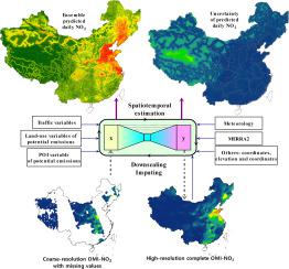
Compared with the limited capability of ground-level monitoring, remote sensing provides useful image data at a moderate or high spatial or temporal resolution with global coverage for monitoring of air pollutants, e.g., aerosol optical depth (AOD) observations from the MODIS for fine particulate matter (PM2.5) and Ozone Monitoring Instrument (OMI) nitrogen dioxide (NO2) vertical columns for ground-level NO2 concentration. However, the extensive nonrandom missingness of OMI-NO2 data (e.g., an approximate per-pixel missing proportion of 59% for mainland China in 2015) due to cloud contamination or high reflectance limits applicability of these data in estimation of ground-level NO2. This paper proposes the use of a full residual deep learning method to impute missing satellite-borne NO2 data (OMI-NO2) and to estimate (map) ground-level NO2 with uncertainty (coefficient of variation) at a high spatial (1 × 1 km2) and temporal (daily) resolution. For the large study region (mainland China except Hainan Province), the presented method achieved robust performance with a stable learning efficiency (mean test R2: 0.98 with a small standard deviation of 0.01; mean test RMSE: 0.42 × 10¹⁵ molecules/cm2) for imputation of OMI-NO2. In the model, the coordinates and elevation were used to capture the spatial variability of the OMI-NO2 columns, and fused meteorological grid data and planetary boundary layer height and ozone data from GEOS-FP were used to capture spatiotemporal variability of OMI-NO2. The evaluation with ground in situ NO2 measurements showed considerable contribution of the complete (raw observed and imputed) OMI-NO2 columns, meteorology and traffic variables to inference of ground-level NO2 (test R2: 0.82; test RMSE: 8.80 μg/m3). The complete grids of OMI-NO2 columns showed natural and smooth spatial transitions between the raw observed and imputed values. The surfaces of predicted NO2 concentration not only showed consistent distributions with OMI-NO2 at a regional and temporal scale, but also presented local spatial gradients of ground-level NO2. OMI-NO2 can be downscaled and imputed to be used as an important predictor to improve the estimation of high-resolution ground-level NO2. The reliable estimates of ground-level NO2 concentration with uncertainty can reduce the bias in estimates of NO2 exposure and subsequently evaluations of its health effects.


 京公网安备 11010802027423号