当前位置:
X-MOL 学术
›
J. Asian Earth Sci.
›
论文详情
Our official English website, www.x-mol.net, welcomes your
feedback! (Note: you will need to create a separate account there.)
The lithospheric structure underneath the Circum Black Sea: Teleseismic receiver functions and Rayleigh wave phase velocity analysis
Journal of Asian Earth Sciences ( IF 2.7 ) Pub Date : 2021-02-01 , DOI: 10.1016/j.jseaes.2020.104652 Hamdi Alkan , Hakan Çınar
Journal of Asian Earth Sciences ( IF 2.7 ) Pub Date : 2021-02-01 , DOI: 10.1016/j.jseaes.2020.104652 Hamdi Alkan , Hakan Çınar
|
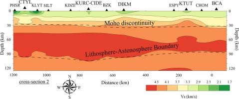
Abstract In this paper, the lithospheric structure underneath the Circum Black Sea is investigated on the basis of teleseismic receiver functions and Rayleigh wave phase velocity analyses. A joint inversion of P- and S-wave receiver functions are performed by using an iterative algorithm, similar to the simulated annealing method. The array method is employed to obtain the Rayleigh wave inter-station phase velocity dispersion curves. The dataset recorded during 2010–2020 by sixteen broadband stations, operated by several seismological agencies, includes more than 450 events (Mw ≥ 5.8). The Moho depth increases northward from 35 km to 40 km along both coastlines. Following the velocity models, it is suggested that the crust structure beneath the stations is the continental type. The lithosphere-asthenosphere boundary ranges from ∼90 km to ∼120 km from the east coast of the East Black Sea basin, while it is low-sloping (from ∼100 km to ∼93 km) for the west coast of the West Black Sea basin, and it is nearly 90 km along with the Pontides. The average P-wave and S-wave velocities inferred from the models indicate the continental lithosphere around the Black Sea coastal region. According to these results, tectonically, it points out that the southward subduction exists in the eastern part of the East Black Sea region beneath the Pontides, while it is not observed in the westernmost Black Sea region.
中文翻译:

Circum Black Sea 下的岩石圈结构:远震接收函数和瑞利波相速度分析
摘要 本文在远震接收函数和瑞利波相速度分析的基础上,研究了环绕黑海海底的岩石圈结构。P 波和 S 波接收器函数的联合反演是通过使用迭代算法来执行的,类似于模拟退火方法。采用阵列法得到瑞利波站间相速度频散曲线。2010-2020 年期间,由多个地震机构运营的 16 个宽带站记录的数据集包括 450 多个事件(Mw ≥ 5.8)。沿两条海岸线,莫霍面深度从 35 公里向北增加到 40 公里。根据速度模型,建议台站下方的地壳结构为大陆型。岩石圈-软流圈边界距东黑海盆地东海岸约 90 公里至约 120 公里,而西黑海西海岸则为低坡度(约 100 公里至约 93 公里)盆地,与庞蒂德斯相距近 90 公里。从模型推断的平均 P 波和 S 波速度表明黑海沿岸地区周围的大陆岩石圈。根据这些结果,从构造上指出,东黑海东部地区在庞蒂德下方存在向南俯冲,而在黑海最西部地区未观察到。从模型推断的平均 P 波和 S 波速度表明黑海沿岸地区周围的大陆岩石圈。根据这些结果,从构造上指出,东黑海东部地区在庞蒂德下方存在向南俯冲,而在黑海最西部地区未观察到。从模型推断的平均 P 波和 S 波速度表明黑海沿岸地区周围的大陆岩石圈。根据这些结果,从构造上指出东黑海东部地区在庞蒂德下方存在向南俯冲,而在黑海最西部地区未观察到。
更新日期:2021-02-01
中文翻译:
Circum Black Sea 下的岩石圈结构:远震接收函数和瑞利波相速度分析
摘要 本文在远震接收函数和瑞利波相速度分析的基础上,研究了环绕黑海海底的岩石圈结构。P 波和 S 波接收器函数的联合反演是通过使用迭代算法来执行的,类似于模拟退火方法。采用阵列法得到瑞利波站间相速度频散曲线。2010-2020 年期间,由多个地震机构运营的 16 个宽带站记录的数据集包括 450 多个事件(Mw ≥ 5.8)。沿两条海岸线,莫霍面深度从 35 公里向北增加到 40 公里。根据速度模型,建议台站下方的地壳结构为大陆型。岩石圈-软流圈边界距东黑海盆地东海岸约 90 公里至约 120 公里,而西黑海西海岸则为低坡度(约 100 公里至约 93 公里)盆地,与庞蒂德斯相距近 90 公里。从模型推断的平均 P 波和 S 波速度表明黑海沿岸地区周围的大陆岩石圈。根据这些结果,从构造上指出,东黑海东部地区在庞蒂德下方存在向南俯冲,而在黑海最西部地区未观察到。从模型推断的平均 P 波和 S 波速度表明黑海沿岸地区周围的大陆岩石圈。根据这些结果,从构造上指出,东黑海东部地区在庞蒂德下方存在向南俯冲,而在黑海最西部地区未观察到。从模型推断的平均 P 波和 S 波速度表明黑海沿岸地区周围的大陆岩石圈。根据这些结果,从构造上指出东黑海东部地区在庞蒂德下方存在向南俯冲,而在黑海最西部地区未观察到。


 京公网安备 11010802027423号