当前位置:
X-MOL 学术
›
J. Appl. Ecol.
›
论文详情
Our official English website, www.x-mol.net, welcomes your
feedback! (Note: you will need to create a separate account there.)
Uncovered pathways: Modelling dispersal dynamics of ship‐mediated marine introduced species
Journal of Applied Ecology ( IF 5.0 ) Pub Date : 2020-12-14 , DOI: 10.1111/1365-2664.13817 Jonas Letschert 1, 2 , Matthias Wolff 2 , Lotta Clara Kluger 2, 3 , Christian Freudinger 2 , John Ronquillo 4 , Inti Keith 5
中文翻译:

未被发现的途径:模拟船舶介导的海洋引进物种的扩散动态
更新日期:2020-12-14
Journal of Applied Ecology ( IF 5.0 ) Pub Date : 2020-12-14 , DOI: 10.1111/1365-2664.13817 Jonas Letschert 1, 2 , Matthias Wolff 2 , Lotta Clara Kluger 2, 3 , Christian Freudinger 2 , John Ronquillo 4 , Inti Keith 5
Affiliation
|
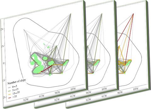
- Marine traffic is the main vector for marine non‐indigenous species (NIS) that may hitchhike in ballast water tanks or attached to vessel hulls. Understanding marine traffic dynamics and estimating the associated risk of NIS dispersal reveals points of leverage for preventive NIS management. This study presents a method to quantify the risk of ship hull fouling‐mediated NIS dispersal and identifies main dispersal hubs in marine traffic networks. We use the Galapagos Marine Reserve (GMR) as a case study to test the applicability of this method.
- Ship position data derived from the automatic identification system (AIS) served as a basis for a network consisting of nodes (moorings and anchorages) and edges (ship routes). Wetted surface areas (WSA) describe the parts of vessel hulls submerged by water and were used to parameterize dispersal risks of individual vessels. We combined the constructed network with a numeric dispersal model and sequentially removed network elements to test their effectiveness on decreasing the overall dispersal capacity.
- Marine traffic hotspots, such as ports and popular marine visitor sites, represented the main dispersal hubs and incoming edges into the GMR crucial links for the overall dispersal capacity. The removal of passenger vessels had the strongest effect on the overall dispersal capacity, reducing it to 1%.
- Based on our findings, we suggest management recommendations to curb the spread of marine NIS in the GMR, including the implementations of (a) vessel hull controls at main dispersal hubs (ports); (b) species monitoring programmes at popular marine visitor sites and (c) hull husbandry regulations for passenger vessels.
- Synthesis and application. In an increasingly connected world, the development of risk assessments for marine non‐indigenous species (NIS) dispersal is a crucial step towards the sustainable use and protection of marine ecosystems in Galapagos and other places. The presented methodology is solely based on the pathway component and thus applicable to any place with available ship position data. Therefore, it may provide useful baseline information for preventive measurements especially in places where ecological data about NIS are scarce.
中文翻译:
未被发现的途径:模拟船舶介导的海洋引进物种的扩散动态
- 海上交通是可能在压舱水舱中搭便车或附着在船体上的海洋非本地物种(NIS)的主要媒介。了解海洋交通动态并估计NIS扩散的相关风险,揭示了预防性NIS管理的杠杆作用点。这项研究提出了一种量化船体污损介导的NIS扩散风险的方法,并确定了海上交通网络中的主要扩散枢纽。我们以加拉帕戈斯海洋保护区(GMR)为例研究这种方法的适用性。
- 从自动识别系统(AIS)得出的船舶位置数据用作由节点(系泊和锚地)和边缘(船舶路线)组成的网络的基础。润湿的表面积(WSA)描述了被水淹没的船体部分,并用于参数化单个船体的扩散风险。我们将构建的网络与数值分散模型结合在一起,并顺序删除了网络元素,以测试其在降低整体分散能力方面的有效性。
- 港口和受欢迎的海上游客地点等海上交通热点,代表了主要的分散枢纽和进入GMR的边缘,这对于整体分散能力至关重要。拆除客船对整体分散能力的影响最大,降至1%。
- 根据我们的发现,我们建议管理层建议遏制海洋NIS在GMR中的传播,包括(a)在主要散布枢纽(港口)实施船体控制措施;(b)受欢迎的海上游客场所的物种监测计划,以及(c)客船的船体饲养规定。
- 综合与应用。在一个日益互联的世界中,开发海洋非本地物种(NIS)扩散的风险评估是加拉帕戈斯群岛和其他地方实现可持续利用和保护海洋生态系统的关键一步。所提出的方法仅基于航路组成部分,因此适用于具有可用船舶位置数据的任何地方。因此,它可以为预防性测量提供有用的基线信息,尤其是在缺少有关NIS的生态数据的地方。


 京公网安备 11010802027423号