当前位置:
X-MOL 学术
›
Earth Planets Space
›
论文详情
Our official English website, www.x-mol.net, welcomes your
feedback! (Note: you will need to create a separate account there.)
Gravimetric geoid modeling from the combination of satellite gravity model, terrestrial and airborne gravity data: a case study in the mountainous area, Colorado
Earth, Planets and Space ( IF 3.0 ) Pub Date : 2020-12-01 , DOI: 10.1186/s40623-020-01287-y Tao Jiang , Yamin Dang , Chuanyin Zhang
Earth, Planets and Space ( IF 3.0 ) Pub Date : 2020-12-01 , DOI: 10.1186/s40623-020-01287-y Tao Jiang , Yamin Dang , Chuanyin Zhang
|
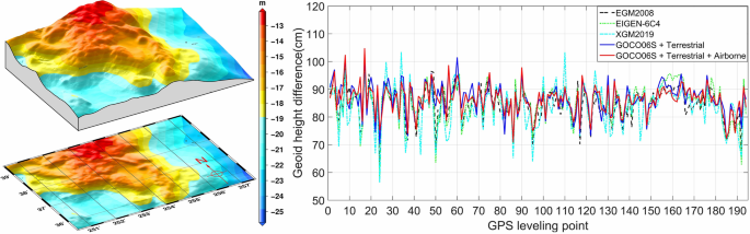
Constructing a high-precision and high-resolution gravimetric geoid model in the mountainous area is a quite challenging task because of the lack of terrestrial gravity observations, rough topography and the geological complexity. One way out is to use high-quality and well-distributed satellite and airborne gravity data to fill the gravity data gaps; thus, the proper combination of heterogeneous gravity datasets is critical. In a rough topographic area in Colorado, we computed a set of gravimetric geoid models based on different combination modes of satellite gravity models, terrestrial and airborne gravity data using the spectral combination method. The gravimetric geoid model obtained from the combination of satellite gravity model GOCO06S and terrestrial gravity data agrees with the GPS leveling measured geoid heights at 194 benchmarks in 5.8 cm in terms of the standard deviation of discrepancies, and the standard deviation reduces to 5.3 cm after including the GRAV-D airborne gravity data collected at ~ 6.2 km altitude into the data combination. The contributions of airborne gravity data to the signal and accuracy improvements of the geoid models were quantified for different spatial distribution and density of terrestrial gravity data. The results demonstrate that, although the airborne gravity survey was flown at a high altitude, the additions of airborne gravity data improved the accuracies of geoid models by 13.4%–19.8% in the mountainous area (elevations > 2000 m) and 12.7%–21% (elevations < 2000 m) in the moderate area in the cases of terrestrial gravity data spacings are larger than 15 km.
中文翻译:

结合卫星重力模型、地面和空中重力数据的重力大地水准面建模:以科罗拉多州山区为例
由于缺乏地面重力观测、地形粗糙和地质复杂,在山区构建高精度、高分辨率的重力大地水准面模型是一项非常具有挑战性的任务。一种出路是利用高质量、分布良好的卫星和机载重力数据来填补重力数据的空白;因此,异构重力数据集的适当组合至关重要。在科罗拉多州的一个粗糙地形区,我们使用光谱组合方法,基于卫星重力模型、地面和机载重力数据的不同组合模式计算了一套重力大地水准面模型。卫星重力模型GOCO06S与地面重力数据结合得到的重力大地水准面模型与5中194个基准点的GPS水准测量大地水准面高度吻合。8 cm 的差异标准偏差,将在~6.2 km 高度采集的 GRAV-D 航空重力数据纳入数据组合后,标准偏差减小到 5.3 cm。针对不同空间分布和密度的地面重力数据,量化了航空重力数据对大地水准面模型信号和精度改进的贡献。结果表明,虽然航空重力测量是在高空飞行,但增加航空重力数据使山区(海拔> 2000 m)大地水准面模型的精度提高了13.4%~19.8%,在山区(海拔> 2000 m)提高了12.7%~21在地面重力数据间隔大于 15 公里的情况下,中等区域的 %(海拔 < 2000 米)。将在~6.2 km高度采集的GRAV-D机载重力数据纳入数据组合后,标准偏差减小到5.3 cm。针对不同空间分布和密度的地面重力数据,量化了航空重力数据对大地水准面模型信号和精度改进的贡献。结果表明,虽然航空重力测量是在高空飞行,但增加航空重力数据使山区(海拔> 2000 m)大地水准面模型的精度提高了13.4%~19.8%,在山区(海拔> 2000 m)提高了12.7%~21在地面重力数据间隔大于 15 公里的情况下,中等区域的 %(海拔 < 2000 米)。将在~6.2 km高度采集的GRAV-D机载重力数据纳入数据组合后,标准偏差减小到5.3 cm。针对不同空间分布和密度的地面重力数据,量化了航空重力数据对大地水准面模型信号和精度改进的贡献。结果表明,虽然航空重力测量是在高空飞行,但增加航空重力数据使山区(海拔> 2000 m)大地水准面模型的精度提高了13.4%~19.8%,在山区(海拔> 2000 m)提高了12.7%~21在地面重力数据间隔大于 15 公里的情况下,中等区域的 %(海拔 < 2000 米)。针对不同空间分布和密度的地面重力数据,量化了航空重力数据对大地水准面模型信号和精度改进的贡献。结果表明,虽然航空重力测量是在高空飞行,但增加航空重力数据使山区(海拔> 2000 m)大地水准面模型的精度提高了13.4%~19.8%,在山区(海拔> 2000 m)提高了12.7%~21在地面重力数据间隔大于 15 公里的情况下,中等区域的 %(海拔 < 2000 米)。针对不同空间分布和密度的地面重力数据,量化了航空重力数据对大地水准面模型信号和精度改进的贡献。结果表明,虽然航空重力测量是在高空飞行,但增加航空重力数据使山区(海拔> 2000 m)大地水准面模型的精度提高了13.4%~19.8%,在山区(海拔> 2000 m)提高了12.7%~21在地面重力数据间隔大于 15 公里的情况下,中等区域的 %(海拔 < 2000 米)。
更新日期:2020-12-01
中文翻译:
结合卫星重力模型、地面和空中重力数据的重力大地水准面建模:以科罗拉多州山区为例
由于缺乏地面重力观测、地形粗糙和地质复杂,在山区构建高精度、高分辨率的重力大地水准面模型是一项非常具有挑战性的任务。一种出路是利用高质量、分布良好的卫星和机载重力数据来填补重力数据的空白;因此,异构重力数据集的适当组合至关重要。在科罗拉多州的一个粗糙地形区,我们使用光谱组合方法,基于卫星重力模型、地面和机载重力数据的不同组合模式计算了一套重力大地水准面模型。卫星重力模型GOCO06S与地面重力数据结合得到的重力大地水准面模型与5中194个基准点的GPS水准测量大地水准面高度吻合。8 cm 的差异标准偏差,将在~6.2 km 高度采集的 GRAV-D 航空重力数据纳入数据组合后,标准偏差减小到 5.3 cm。针对不同空间分布和密度的地面重力数据,量化了航空重力数据对大地水准面模型信号和精度改进的贡献。结果表明,虽然航空重力测量是在高空飞行,但增加航空重力数据使山区(海拔> 2000 m)大地水准面模型的精度提高了13.4%~19.8%,在山区(海拔> 2000 m)提高了12.7%~21在地面重力数据间隔大于 15 公里的情况下,中等区域的 %(海拔 < 2000 米)。将在~6.2 km高度采集的GRAV-D机载重力数据纳入数据组合后,标准偏差减小到5.3 cm。针对不同空间分布和密度的地面重力数据,量化了航空重力数据对大地水准面模型信号和精度改进的贡献。结果表明,虽然航空重力测量是在高空飞行,但增加航空重力数据使山区(海拔> 2000 m)大地水准面模型的精度提高了13.4%~19.8%,在山区(海拔> 2000 m)提高了12.7%~21在地面重力数据间隔大于 15 公里的情况下,中等区域的 %(海拔 < 2000 米)。将在~6.2 km高度采集的GRAV-D机载重力数据纳入数据组合后,标准偏差减小到5.3 cm。针对不同空间分布和密度的地面重力数据,量化了航空重力数据对大地水准面模型信号和精度改进的贡献。结果表明,虽然航空重力测量是在高空飞行,但增加航空重力数据使山区(海拔> 2000 m)大地水准面模型的精度提高了13.4%~19.8%,在山区(海拔> 2000 m)提高了12.7%~21在地面重力数据间隔大于 15 公里的情况下,中等区域的 %(海拔 < 2000 米)。针对不同空间分布和密度的地面重力数据,量化了航空重力数据对大地水准面模型信号和精度改进的贡献。结果表明,虽然航空重力测量是在高空飞行,但增加航空重力数据使山区(海拔> 2000 m)大地水准面模型的精度提高了13.4%~19.8%,在山区(海拔> 2000 m)提高了12.7%~21在地面重力数据间隔大于 15 公里的情况下,中等区域的 %(海拔 < 2000 米)。针对不同空间分布和密度的地面重力数据,量化了航空重力数据对大地水准面模型信号和精度改进的贡献。结果表明,虽然航空重力测量是在高空飞行,但增加航空重力数据使山区(海拔> 2000 m)大地水准面模型的精度提高了13.4%~19.8%,在山区(海拔> 2000 m)提高了12.7%~21在地面重力数据间隔大于 15 公里的情况下,中等区域的 %(海拔 < 2000 米)。


 京公网安备 11010802027423号