当前位置:
X-MOL 学术
›
J. Appl. Ecol.
›
论文详情
Our official English website, www.x-mol.net, welcomes your
feedback! (Note: you will need to create a separate account there.)
Using generalised dissimilarity modelling and targeted field surveys to gap‐fill an ecosystem surveillance network
Journal of Applied Ecology ( IF 5.0 ) Pub Date : 2020-12-07 , DOI: 10.1111/1365-2664.13814 Greg R. Guerin 1, 2 , Kristen J. Williams 3 , Emrys Leitch 1, 2 , Andrew J. Lowe 1 , Ben Sparrow 1, 2
中文翻译:

使用广义差异模型和有针对性的现场调查来填补生态系统监测网络的空白
更新日期:2020-12-07
Journal of Applied Ecology ( IF 5.0 ) Pub Date : 2020-12-07 , DOI: 10.1111/1365-2664.13814 Greg R. Guerin 1, 2 , Kristen J. Williams 3 , Emrys Leitch 1, 2 , Andrew J. Lowe 1 , Ben Sparrow 1, 2
Affiliation
|
- Effective ecosystem management requires spatially distributed measurements that are representative of ecological diversity. When considering which sites complement existing conservation or monitoring networks, there are many strategies for optimising ecological coverage in the absence of ground observations. However, such optimisation is often implemented theoretically in conservation prioritisation frameworks and real‐world implementation is rarely assessed, particularly for monitoring networks.
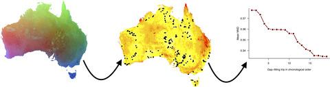
- We assessed the performance of adding new survey sites informed by predictive modelling in gap‐filling the ecological coverage of the Terrestrial Ecosystem Research Network's (TERN) continental network of ecosystem surveillance plots, Ausplots. We constructed a generalised dissimilarity model (GDM) in which plant species composition in 531 sites was fitted to environmental parameters. We combined predicted nearest‐neighbour ecological distances for locations across Australia with practical considerations to select regions for gap‐filling surveys of 181 new plots across 18 expeditions. We iteratively tracked the reduction in mean nearest‐neighbour distances in GDM space, and increases in the actual sampling of ecological space, using cumulative multivariate dispersion.
- The generalised dissimilarity model explained 34% of deviance in species compositional turnover as a function of geographic distance, soil P, aridity, actual evapotranspiration and rainfall seasonality, among 17 significant predictors.
- We targeted identified gap regions in the Australian jurisdictions of Queensland, New South Wales and Western Australia for surveys in addition to opportunistic or project‐based gap‐filling over 2 years. Approximately 20% of the land area of Australia received increased servicing of biological representation, corresponding to a reduction in mean nearest‐neighbour ecological distances from 0.38 to 0.33 in units of compositional dissimilarity. The corresponding increase in sampled ecological space was 172% more than that achieved from the previous 181 plots.
- Synthesis and applications. Increases in the representation of ecosystems included in surveillance networks can be achieved efficiently using objective methods for site selection and appraisal. Scaling of environmental variables through ecological models supports practical sampling decisions, while optimising putative survey locations via their ecological distance to a nearest neighbour is useful when the aim is to increase inclusion of habitats. Iterations between modelled gaps and field campaigns provide a pragmatic compromise between theoretical optima and real‐world decision‐making.
中文翻译:
使用广义差异模型和有针对性的现场调查来填补生态系统监测网络的空白
- 有效的生态系统管理需要代表生态多样性的空间分布测量。当考虑哪些地点补充了现有的保护或监测网络时,有许多策略可以在没有地面观测的情况下优化生态覆盖范围。但是,这种优化通常是在理论上在保护优先次序框架中实施的,很少评估实际的实施情况,尤其是对于监控网络。
- 我们评估了在预测模型的基础上增加新的调查地点在填补陆地生态系统研究网(TERN)的生态系统监视区(Ausplots)大陆网络的生态覆盖方面的性能。我们构建了一个通用的差异模型(GDM),其中531个地点的植物物种组成与环境参数相符。我们结合了澳大利亚各地预测的最近邻生态距离与实际考虑因素,以选择区域进行18个考察的181个新地块的填空调查。我们使用累积的多元离散度来迭代地跟踪GDM空间中平均最近邻距离的减少,以及实际生态空间采样中的增加。
- 广义差异模型解释了17种重要预测因子中,物种组成变化中34%的偏差与地理距离,土壤磷,干旱,实际蒸散量和降雨季节的关系。
- 我们将昆士兰州,新南威尔士州和西澳大利亚州的澳大利亚辖区中已确定的差距区域作为调查对象,并在两年内进行了机会主义或基于项目的差距填补。澳大利亚约有20%的土地面积提供了更多的生物表征服务,这对应于近邻平均生态距离(以成分差异为单位)从0.38降低至0.33。与以前的181个样地相比,采样的生态空间相应增加了172%。
- 综合与应用。使用客观的地点选择和评估方法,可以有效地实现监测网络中生态系统代表性的增加。通过生态模型缩放环境变量可支持实际的采样决策,而当目的是增加生境的涵盖范围时,通过其与最近邻居的生态距离来优化推定的调查位置将非常有用。建模的差距与实地活动之间的迭代为理论上的最优与现实世界的决策之间提供了务实的折衷方案。


 京公网安备 11010802027423号