当前位置:
X-MOL 学术
›
WIREs Water
›
论文详情
Our official English website, www.x-mol.net, welcomes your feedback! (Note: you will need to create a separate account there.)
A little relief: Ecological functions and autogenesis of wetland microtopography
WIREs Water ( IF 8.2 ) Pub Date : 2020-12-03 , DOI: 10.1002/wat2.1493 Jacob S. Diamond, Joshua M. Epstein, Matthew J. Cohen, Daniel L. McLaughlin, Yu‐Hsin Hsueh, Richard F. Keim, Jamie A. Duberstein
WIREs Water ( IF 8.2 ) Pub Date : 2020-12-03 , DOI: 10.1002/wat2.1493 Jacob S. Diamond, Joshua M. Epstein, Matthew J. Cohen, Daniel L. McLaughlin, Yu‐Hsin Hsueh, Richard F. Keim, Jamie A. Duberstein
|
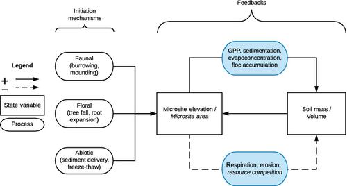
Microtopography, or the small‐scale variation in ground surface height (10−1–100 m) over short (100–102 m) spatial scales, is a ubiquitous feature of wetlands globally. This variation in elevation, characterized by local high (“hummocks”) and low (“hollows”) patches, is more structured than what is observed in uplands, and is intertwined with concordantly structured spatiotemporal variability in hydrologic regimes and associated ecological processes. The importance of microtopography in wetlands is manifold, with critical influence on local hydrological, biogeochemical, and biological processes. Further, the creation and maintenance of wetland microtopography is a balance between activation processes (i.e., those that induce random elevation variation) and autogenic reinforcement processes (i.e., those that provide the feedbacks necessary for the persistence of microtopography). While there are many mechanisms that create vertical structure (e.g., tree falls, accumulation of roots and soil organic matter, and sediment deposition), they all yield a similar core feedback to enhance and sustain microtopographic structure. Finally, microtopography contributes to spatial patterning that confers emergent ecosystem‐scale functions such as hydrologic storage and flows, carbon cycling, organism dispersal, and biodiversity. There is an ongoing need to study the origins and implications of this fine‐scale variation in elevation, as well as the utility of including microtopography in model predictions and ecological restoration efforts.
中文翻译:

一点缓解:湿地微地形的生态功能和自生
微观形貌,或 在短时间内(10 0 –10 2)的地面高度(10 -1 –10 0 m)的小规模变化 m)空间尺度是全球湿地普遍存在的特征。这种高程变化的特征是局部高(“山岗”)和低(“凹陷”)斑块,其结构比高地高,在水文状况和相关的生态过程中,结构时空的变化是一致的。在湿地中微地形的重要性是多方面的,对当地的水文,生物地球化学和生物过程具有重要影响。此外,湿地微地形的创建和维护是激活过程(即那些引起随机海拔变化的过程)和自生强化过程(即那些为持久保留微地形提供必要反馈的过程)之间的平衡。虽然有许多机制可以创建垂直结构(例如,树木倒下,根和土壤有机质的积累以及沉积物的沉积),它们都会产生相似的核心反馈,从而增强和维持微观地形结构。最后,微观地形有助于空间格局的形成,赋予生态系统规模的新兴功能,例如水文存储和流动,碳循环,生物扩散和生物多样性。迫切需要研究这种小尺度的海拔变化的起源和含义,以及将微地形包括在模型预测和生态修复工作中的实用性。微观形貌有助于赋予空间格局,赋予生态系统规模的新兴功能,例如水文存储和流动,碳循环,生物扩散和生物多样性。迫切需要研究这种小尺度的海拔变化的起源和含义,以及将微地形包括在模型预测和生态修复工作中的实用性。微观形貌有助于赋予空间格局,赋予生态系统规模的新兴功能,例如水文存储和流动,碳循环,生物扩散和生物多样性。迫切需要研究这种小尺度的海拔变化的起源和含义,以及将微地形包括在模型预测和生态修复工作中的实用性。
更新日期:2020-12-20
中文翻译:
一点缓解:湿地微地形的生态功能和自生
微观形貌,或 在短时间内(10 0 –10 2)的地面高度(10 -1 –10 0 m)的小规模变化 m)空间尺度是全球湿地普遍存在的特征。这种高程变化的特征是局部高(“山岗”)和低(“凹陷”)斑块,其结构比高地高,在水文状况和相关的生态过程中,结构时空的变化是一致的。在湿地中微地形的重要性是多方面的,对当地的水文,生物地球化学和生物过程具有重要影响。此外,湿地微地形的创建和维护是激活过程(即那些引起随机海拔变化的过程)和自生强化过程(即那些为持久保留微地形提供必要反馈的过程)之间的平衡。虽然有许多机制可以创建垂直结构(例如,树木倒下,根和土壤有机质的积累以及沉积物的沉积),它们都会产生相似的核心反馈,从而增强和维持微观地形结构。最后,微观地形有助于空间格局的形成,赋予生态系统规模的新兴功能,例如水文存储和流动,碳循环,生物扩散和生物多样性。迫切需要研究这种小尺度的海拔变化的起源和含义,以及将微地形包括在模型预测和生态修复工作中的实用性。微观形貌有助于赋予空间格局,赋予生态系统规模的新兴功能,例如水文存储和流动,碳循环,生物扩散和生物多样性。迫切需要研究这种小尺度的海拔变化的起源和含义,以及将微地形包括在模型预测和生态修复工作中的实用性。微观形貌有助于赋予空间格局,赋予生态系统规模的新兴功能,例如水文存储和流动,碳循环,生物扩散和生物多样性。迫切需要研究这种小尺度的海拔变化的起源和含义,以及将微地形包括在模型预测和生态修复工作中的实用性。


 京公网安备 11010802027423号