当前位置:
X-MOL 学术
›
Earth Surf.Process. Land.
›
论文详情
Our official English website, www.x-mol.net, welcomes your
feedback! (Note: you will need to create a separate account there.)
Morphology and evolution of supraglacial hummocks on debris‐covered Himalayan glaciers
Earth Surface Processes and Landforms ( IF 2.8 ) Pub Date : 2020-12-03 , DOI: 10.1002/esp.5043 Oliver T. Bartlett 1, 2, 3 , Felix S.L. Ng 2 , Ann V. Rowan 2
Earth Surface Processes and Landforms ( IF 2.8 ) Pub Date : 2020-12-03 , DOI: 10.1002/esp.5043 Oliver T. Bartlett 1, 2, 3 , Felix S.L. Ng 2 , Ann V. Rowan 2
Affiliation
|
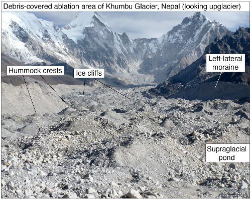
Thick supraglacial debris layers often have an undulating, hummocky topography that influences the lateral transport of debris and meltwater and provides basins for supraglacial ponds. The role of ablation and other processes associated with supraglacial debris in giving rise to this hummocky topography is poorly understood. Characterizing hummocky topography is a first step towards understanding the feedbacks driving the evolution of debris‐covered glacier surfaces and their potential impacts on mass balance, hydrology and glacier dynamics. Here we undertake a geomorphological assessment of the hummocky topography on five debris‐covered glaciers in the Everest region of the central Himalaya. We characterize supraglacial hummocks through statistical analyses of their vertical relief and horizontal geometry. Our results establish supraglacial hummocks as a distinct landform. We find that a typical hummock has an elongation ratio of 1.1:1 in the direction of ice flow, length of 214 ± 109 m and width of 192 ± 88 m. Hummocky topography has a greater amplitude across‐glacier (15.4 ± 10.9 m) compared to along the glacier flow line (12.6 ± 8.3 m). Consequently, hummock slopes are steeper in the across‐glacier direction (8.7 ± 4.3°) than in the direction of ice flow (5.6 ± 4.0°). Longer, wider and higher‐amplitude hummocks are found on larger glaciers. We postulate that directional anisotropy in the hummock topography arises because, while the pattern of differential ablation driving topography evolution is moderated by processes including the gravitational redistribution of debris across the glacier surface, it also inherits an orientation preference from the distribution of englacial debris in the underlying ice. Our morphometric data inform future efforts to model these interactions, which should account for additional factors such as the genesis of supraglacial ponds and ice cliffs and their impact on differential ablation.
中文翻译:

碎屑覆盖的喜马拉雅冰川上的冰缘山岗的形态和演化
厚的滩上碎屑层通常具有起伏的,高高的地形,这会影响碎屑和融水的横向输送,并为滩上池塘提供了盆地。消融和与舌上碎屑相关的其他过程在产生这种山形地形方面的作用知之甚少。表征丘陵地貌是迈向了解驱动碎片覆盖冰川表面演变及其对质量平衡,水文和冰川动力学的潜在影响的反馈的第一步。在这里,我们对喜马拉雅山中部珠穆朗玛峰地区的五个碎屑覆盖的冰川的山岗形貌进行了地貌评估。我们通过统计分析其垂直浮雕和水平几何特征来描述冰川上的山岗。我们的研究结果建立了冰川上的山岗,形成了独特的地形。我们发现,典型的吊床在冰流方向上的伸长率为1.1:1,长度为214±109 m,宽度为192±88 m。与沿冰川流线(12.6±8.3 m)相比,洪堡地形在整个冰川上的振幅更大(15.4±10.9 m)。因此,在跨冰川的方向(8.7±4.3°)比在冰流动的方向(5.6±4.0°)的山坡坡度更陡。在较大的冰川上发现了更长,更宽,振幅更大的山岗。我们假设在山岗形地形中会出现方向各向异性,这是因为,虽然差分消融驱动形貌演变的模式受到包括冰川表面碎屑的重力重分布在内的过程的调节,它也从下层冰层中的冰屑分布中继承了方向性偏好。我们的形态学数据为将来对这些相互作用进行建模的努力提供了信息,这些相互作用应考虑到其他因素,例如冰河池和冰崖的成因及其对差分消融的影响。
更新日期:2020-12-03
中文翻译:
碎屑覆盖的喜马拉雅冰川上的冰缘山岗的形态和演化
厚的滩上碎屑层通常具有起伏的,高高的地形,这会影响碎屑和融水的横向输送,并为滩上池塘提供了盆地。消融和与舌上碎屑相关的其他过程在产生这种山形地形方面的作用知之甚少。表征丘陵地貌是迈向了解驱动碎片覆盖冰川表面演变及其对质量平衡,水文和冰川动力学的潜在影响的反馈的第一步。在这里,我们对喜马拉雅山中部珠穆朗玛峰地区的五个碎屑覆盖的冰川的山岗形貌进行了地貌评估。我们通过统计分析其垂直浮雕和水平几何特征来描述冰川上的山岗。我们的研究结果建立了冰川上的山岗,形成了独特的地形。我们发现,典型的吊床在冰流方向上的伸长率为1.1:1,长度为214±109 m,宽度为192±88 m。与沿冰川流线(12.6±8.3 m)相比,洪堡地形在整个冰川上的振幅更大(15.4±10.9 m)。因此,在跨冰川的方向(8.7±4.3°)比在冰流动的方向(5.6±4.0°)的山坡坡度更陡。在较大的冰川上发现了更长,更宽,振幅更大的山岗。我们假设在山岗形地形中会出现方向各向异性,这是因为,虽然差分消融驱动形貌演变的模式受到包括冰川表面碎屑的重力重分布在内的过程的调节,它也从下层冰层中的冰屑分布中继承了方向性偏好。我们的形态学数据为将来对这些相互作用进行建模的努力提供了信息,这些相互作用应考虑到其他因素,例如冰河池和冰崖的成因及其对差分消融的影响。


 京公网安备 11010802027423号