当前位置:
X-MOL 学术
›
Earth Surf.Process. Land.
›
论文详情
Our official English website, www.x-mol.net, welcomes your
feedback! (Note: you will need to create a separate account there.)
Surface velocity fields of active rock glaciers and ice‐debris complexes in the Central Andes of Argentina
Earth Surface Processes and Landforms ( IF 2.8 ) Pub Date : 2020-12-02 , DOI: 10.1002/esp.5042 Jan Henrik Blöthe 1, 2 , Christian Halla 2 , Ellen Schwalbe 3 , Estefania Bottegal 4 , Dario Trombotto Liaudat 4 , Lothar Schrott 2
Earth Surface Processes and Landforms ( IF 2.8 ) Pub Date : 2020-12-02 , DOI: 10.1002/esp.5042 Jan Henrik Blöthe 1, 2 , Christian Halla 2 , Ellen Schwalbe 3 , Estefania Bottegal 4 , Dario Trombotto Liaudat 4 , Lothar Schrott 2
Affiliation
|
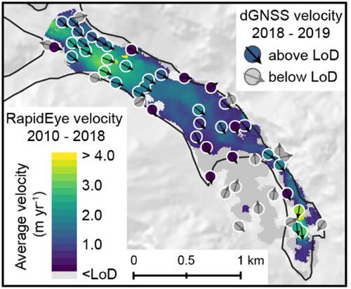
Rock glaciers and transitional ice‐debris complexes predominate the Central Andean landform assemblage, yet regional studies on their state of activity and their kinematics remain sparse. Here we utilize the national glacier inventory of Argentina to quantify surface velocity fields of 244 rock glaciers and 51 ice‐debris complexes, located in the Cordón del Plata range, Argentina. Applying a feature‐tracking approach to repeated RapidEye satellite imagery acquired between 2010 and 2017/18, we find mean displacement rates between 0.37 and 2.61 m year−1 for 149 landforms, while for the remaining 146 features, surface movement remains below our level of detection. We compare our satellite‐derived velocity fields with ground‐truth data from two local field sites and find closely matching results in magnitude and spatial distribution. With average displacement of one‐third of the active rock glaciers and ice‐debris complexes exceeding 1 m year−1, the region hosts an exceptional number of fast‐flowing periglacial landforms, compared to other mountain belts. Using a random forest model, we test the predictive power of 25 morphometric and topoclimatic candidate predictors for modelling the state of activity of rock glaciers and ice‐debris complexes on two different scales. For entire landforms and individual landform segments, constructed along displacement centrelines, we can predict the state of activity with overall accuracies of 70.08% (mean AUROC = 0.785) and 74.86% (mean AUROC = 0.753), respectively. While topoclimatic parameters such as solar radiation and elevation are most important for entire landforms, geometric parameters become more important at the scale of landform segments. Despite tentative correlations between local slope and surface kinematics, our results point to factors integrating slope and distance to the source to govern local deformation. We conclude that feature tracking in optical imagery is feasible for regional studies in remote regions and provides valuable insight into the current state of the Andean cryosphere. © 2020 The Authors. Earth Surface Processes and Landforms published by John Wiley & Sons Ltd
中文翻译:

阿根廷中部安第斯山脉中活跃的岩石冰川和冰屑复合体的表面速度场
岩石冰川和过渡性冰屑复合体在安第斯中部地貌组合中占主导地位,但对其活动状态和运动学的区域性研究仍然很少。在这里,我们利用阿根廷的国家冰川清单来量化位于阿根廷科尔多普拉塔山脉范围内的244个冰川和51个冰屑复合体的表面速度场。将特征跟踪方法应用于2010年至2017/18年间获取的重复RapidEye卫星图像,我们发现平均位移率在0.37至2.61 m年-1之间对于149种地貌,对于其余146种地物,地表运动仍低于我们的检测水平。我们将来自卫星的速度场与来自两个本地现场的地面真实数据进行比较,发现幅度和空间分布紧密匹配的结果。三分之一的活跃岩石冰川和冰屑复合体的平均位移超过100万年-1,与其他山区相比,该地区拥有数量众多的快速流动的冰川地貌。使用随机森林模型,我们测试了25种形态计量学和地形气候候选预测器的预测能力,以两种不同的尺度对岩石冰川和冰屑复合体的活动状态进行建模。对于沿着位移中心线构建的整个地形和单个地形段,我们可以预测活动状态,其总体准确度分别为70.08%(平均AUROC = 0.785)和74.86%(平均AUROC = 0.753)。虽然诸如地形和海拔等地形气候参数对于整个地貌最为重要,但几何参数在地貌分段的规模上变得更为重要。尽管局部坡度和表面运动学之间存在暂时的相关性,我们的结果指出了积分斜率和到震源的距离以控制局部变形的因素。我们得出结论,光学影像中的特征跟踪对于边远地区的区域研究是可行的,并提供了对安第斯冰冻圈当前状态的宝贵见解。©2020作者。约翰·威利父子有限公司出版的《地球表面过程和地形》
更新日期:2021-02-10
中文翻译:
阿根廷中部安第斯山脉中活跃的岩石冰川和冰屑复合体的表面速度场
岩石冰川和过渡性冰屑复合体在安第斯中部地貌组合中占主导地位,但对其活动状态和运动学的区域性研究仍然很少。在这里,我们利用阿根廷的国家冰川清单来量化位于阿根廷科尔多普拉塔山脉范围内的244个冰川和51个冰屑复合体的表面速度场。将特征跟踪方法应用于2010年至2017/18年间获取的重复RapidEye卫星图像,我们发现平均位移率在0.37至2.61 m年-1之间对于149种地貌,对于其余146种地物,地表运动仍低于我们的检测水平。我们将来自卫星的速度场与来自两个本地现场的地面真实数据进行比较,发现幅度和空间分布紧密匹配的结果。三分之一的活跃岩石冰川和冰屑复合体的平均位移超过100万年-1,与其他山区相比,该地区拥有数量众多的快速流动的冰川地貌。使用随机森林模型,我们测试了25种形态计量学和地形气候候选预测器的预测能力,以两种不同的尺度对岩石冰川和冰屑复合体的活动状态进行建模。对于沿着位移中心线构建的整个地形和单个地形段,我们可以预测活动状态,其总体准确度分别为70.08%(平均AUROC = 0.785)和74.86%(平均AUROC = 0.753)。虽然诸如地形和海拔等地形气候参数对于整个地貌最为重要,但几何参数在地貌分段的规模上变得更为重要。尽管局部坡度和表面运动学之间存在暂时的相关性,我们的结果指出了积分斜率和到震源的距离以控制局部变形的因素。我们得出结论,光学影像中的特征跟踪对于边远地区的区域研究是可行的,并提供了对安第斯冰冻圈当前状态的宝贵见解。©2020作者。约翰·威利父子有限公司出版的《地球表面过程和地形》


 京公网安备 11010802027423号