当前位置:
X-MOL 学术
›
WIREs Water
›
论文详情
Our official English website, www.x-mol.net, welcomes your
feedback! (Note: you will need to create a separate account there.)
Applications of Google Earth Engine in fluvial geomorphology for detecting river channel change
WIREs Water ( IF 6.8 ) Pub Date : 2020-12-01 , DOI: 10.1002/wat2.1496 Richard J. Boothroyd 1 , Richard D. Williams 1 , Trevor B. Hoey 2 , Brian Barrett 1 , Octria A. Prasojo 1
WIREs Water ( IF 6.8 ) Pub Date : 2020-12-01 , DOI: 10.1002/wat2.1496 Richard J. Boothroyd 1 , Richard D. Williams 1 , Trevor B. Hoey 2 , Brian Barrett 1 , Octria A. Prasojo 1
Affiliation
|
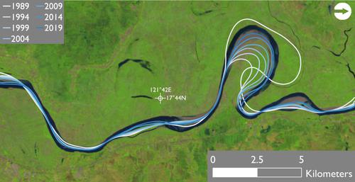
Cloud‐based computing, access to big geospatial data, and virtualization, whereby users are freed from computational hardware and data management logistics, could revolutionize remote sensing applications in fluvial geomorphology. Analysis of multitemporal, multispectral satellite imagery has provided fundamental geomorphic insight into the planimetric form and dynamics of large river systems, but information derived from these applications has largely been used to test existing concepts in fluvial geomorphology, rather than for generating new concepts or theories. Traditional approaches (i.e., desktop computing) have restricted the spatial scales and temporal resolutions of planimetric river channel change analyses. Google Earth Engine (GEE), a cloud‐based computing platform for planetary‐scale geospatial analyses, offers the opportunity to relieve these spatiotemporal restrictions. We summarize the big geospatial data flows available to fluvial geomorphologists within the GEE data catalog, focus on approaches to look beyond mapping wet channel extents and instead map the wider riverscape (i.e., water, sediment, vegetation) and its dynamics, and explore the unprecedented spatiotemporal scales over which GEE analyses can be applied. We share a demonstration workflow to extract active river channel masks from a section of the Cagayan River (Luzon, Philippines) then quantify centerline migration rates from multitemporal data. By enabling fluvial geomorphologists to take their algorithms to petabytes worth of data, GEE is transformative in enabling deterministic science at scales defined by the user and determined by the phenomena of interest. Equally as important, GEE offers a mechanism for promoting a cultural shift toward open science, through the democratization of access and sharing of reproducible code.
中文翻译:

Google Earth Engine在河流地貌学中检测河道变化的应用
基于云的计算,对大地理空间数据的访问以及虚拟化,可以使用户摆脱计算硬件和数据管理后勤的束缚,这可能会改变河流应用程序在地貌上的意义。多时相,多光谱卫星影像的分析为大型河流系统的平面形式和动力学提供了基本的地貌学见识,但是从这些应用程序中获得的信息已被大量用于测试河流地貌学中的现有概念,而不是用于产生新的概念或理论。传统方法(即桌面计算)限制了平面河道变化分析的空间尺度和时间分辨率。Google Earth Engine(GEE),一种基于云的计算平台,用于行星尺度的地理空间分析,提供了缓解这些时空限制的机会。我们总结了GEE数据目录中可供河流地貌学家使用的大量地理空间数据流,着重研究了除绘制湿河道范围之外,还绘制了更广阔的河景(即水,沉积物,植被)及其动态的方法,并探索了前所未有的方法。可以应用GEE分析的时空尺度。我们共享一个演示工作流程,以从卡加延河(菲律宾吕宋)的一部分中提取活跃的河道口罩,然后从多时相数据中量化中心线迁移率。通过使河流地貌学家能够将他们的算法应用于价值PB的数据,GEE在以用户定义并由感兴趣的现象确定的尺度上进行确定性科学方面具有变革性。
更新日期:2020-12-20
中文翻译:
Google Earth Engine在河流地貌学中检测河道变化的应用
基于云的计算,对大地理空间数据的访问以及虚拟化,可以使用户摆脱计算硬件和数据管理后勤的束缚,这可能会改变河流应用程序在地貌上的意义。多时相,多光谱卫星影像的分析为大型河流系统的平面形式和动力学提供了基本的地貌学见识,但是从这些应用程序中获得的信息已被大量用于测试河流地貌学中的现有概念,而不是用于产生新的概念或理论。传统方法(即桌面计算)限制了平面河道变化分析的空间尺度和时间分辨率。Google Earth Engine(GEE),一种基于云的计算平台,用于行星尺度的地理空间分析,提供了缓解这些时空限制的机会。我们总结了GEE数据目录中可供河流地貌学家使用的大量地理空间数据流,着重研究了除绘制湿河道范围之外,还绘制了更广阔的河景(即水,沉积物,植被)及其动态的方法,并探索了前所未有的方法。可以应用GEE分析的时空尺度。我们共享一个演示工作流程,以从卡加延河(菲律宾吕宋)的一部分中提取活跃的河道口罩,然后从多时相数据中量化中心线迁移率。通过使河流地貌学家能够将他们的算法应用于价值PB的数据,GEE在以用户定义并由感兴趣的现象确定的尺度上进行确定性科学方面具有变革性。


 京公网安备 11010802027423号