当前位置:
X-MOL 学术
›
Earth Surf.Process. Land.
›
论文详情
Our official English website, www.x-mol.net, welcomes your
feedback! (Note: you will need to create a separate account there.)
Observations on decadal sandbar behaviour along a large‐scale curved shoreline
Earth Surface Processes and Landforms ( IF 2.8 ) Pub Date : 2020-11-28 , DOI: 10.1002/esp.5041 R. Gijsman 1, 2 , B.G. Ruessink 3 , J. Visscher 1 , T. Schlurmann 1
Earth Surface Processes and Landforms ( IF 2.8 ) Pub Date : 2020-11-28 , DOI: 10.1002/esp.5041 R. Gijsman 1, 2 , B.G. Ruessink 3 , J. Visscher 1 , T. Schlurmann 1
Affiliation
|
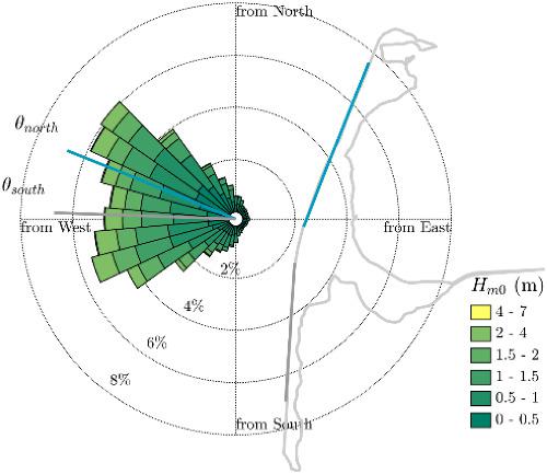
Nearshore sandbars are characteristic features of sandy surf zones and have been observed with a variety of geometries in cross‐shore (e.g. location) and longshore direction (e.g. planform). Although the behaviour of sandbars has been studied extensively on spatial scales up to kilometres and timescales up to years, it remains challenging to observe and explain their behaviour on larger spatial and temporal scales, especially in locations where coastline curvature can be prominent. In this paper, we study a data set with 38 years of coastal profiles, collected with alongshore intervals of 50 m, along the 34 km‐long curved sandy shoreline of Sylt island, Germany. Sylt's shoreline has an orientation difference of ~20° between the northern and southern half of the island. We found that the decadal coastal profiles on the southern half show features of a low‐tide terrace and a sandbar located further from the shoreline (~441 m). On the nothern half, the sandbar was located closer to the shoreline (~267 m) and was less pronounced, while the profiles show transverse bar and rip features. The alongshore planform also differed systematically and significantly along the two island sides. The sandbar on the southern island half, with alongshore periodicity on a larger length scale (~2240 m), was coupled out‐of‐phase to the shoreline, while no phase coupling was observed for the sandbar with periodicity on a shorter length scale (~670 m) on the northern half. We related the observed geometric differences of the sandbars to the difference in the local wave climate along Sylt, imposed by the shoreline shape. Our observations imply that small alongshore variations in wave climate, due to the increasing shoreline curvature on larger spatial scales, can lead to significant alongshore differences in the decadal evolution of coastal profiles, sandbars and shorelines. © 2020 The Authors. Earth Surface Processes and Landforms published by John Wiley & Sons Ltd
中文翻译:

大型弧形海岸线上年代际沙洲行为的观测
近岸沙洲是沙质冲浪区的特征,在跨岸(例如位置)和长岸方向(例如平面形状)的各种几何形状中都可以观察到。尽管沙洲的行为已在长达数千米的空间尺度和长达数年的时间尺度上进行了广泛的研究,但要在更大的时空尺度上观察和解释其行为仍然具有挑战性,尤其是在海岸线曲率明显的地方。在本文中,我们研究了沿叙尔特岛34公里长的弯曲沙质海岸线沿岸间隔50 m收集的具有38年沿海剖面的数据集。叙尔特岛的海岸线在该岛的北半部和南半部之间的方向差约为20°。我们发现,南半部的年代际沿海剖面显示出低潮阶和距海岸线(〜441 m)较远的沙洲的特征。在北半部,沙洲位于靠近海岸线(〜267 m)的位置,并且不太明显,而剖面显示出横杠和裂谷特征。沿岸的平面图在两个岛屿两侧也有系统的差异。南部岛一半的沙洲,沿岸的周期性具有较大的长度尺度(〜2240 m),与海岸线呈异相耦合,而沙洲的沙洲在较短的尺度上没有相位耦合(北半部约670 m)。我们将观察到的沙洲的几何差异与沿海岸线形状造成的沿叙尔特河沿岸的局部波浪气候的差异联系起来。我们的观察结果表明,由于较大空间尺度上海岸线曲率的增加,波浪气候的近岸变化较小,可能会导致沿海剖面,沙洲和海岸线的年代际演变产生明显的沿海差异。©2020作者。约翰·威利父子有限公司出版的《地球表面过程和地形》
更新日期:2020-11-28
中文翻译:
大型弧形海岸线上年代际沙洲行为的观测
近岸沙洲是沙质冲浪区的特征,在跨岸(例如位置)和长岸方向(例如平面形状)的各种几何形状中都可以观察到。尽管沙洲的行为已在长达数千米的空间尺度和长达数年的时间尺度上进行了广泛的研究,但要在更大的时空尺度上观察和解释其行为仍然具有挑战性,尤其是在海岸线曲率明显的地方。在本文中,我们研究了沿叙尔特岛34公里长的弯曲沙质海岸线沿岸间隔50 m收集的具有38年沿海剖面的数据集。叙尔特岛的海岸线在该岛的北半部和南半部之间的方向差约为20°。我们发现,南半部的年代际沿海剖面显示出低潮阶和距海岸线(〜441 m)较远的沙洲的特征。在北半部,沙洲位于靠近海岸线(〜267 m)的位置,并且不太明显,而剖面显示出横杠和裂谷特征。沿岸的平面图在两个岛屿两侧也有系统的差异。南部岛一半的沙洲,沿岸的周期性具有较大的长度尺度(〜2240 m),与海岸线呈异相耦合,而沙洲的沙洲在较短的尺度上没有相位耦合(北半部约670 m)。我们将观察到的沙洲的几何差异与沿海岸线形状造成的沿叙尔特河沿岸的局部波浪气候的差异联系起来。我们的观察结果表明,由于较大空间尺度上海岸线曲率的增加,波浪气候的近岸变化较小,可能会导致沿海剖面,沙洲和海岸线的年代际演变产生明显的沿海差异。©2020作者。约翰·威利父子有限公司出版的《地球表面过程和地形》


 京公网安备 11010802027423号