当前位置:
X-MOL 学术
›
Ocean Coast Manage.
›
论文详情
Our official English website, www.x-mol.net, welcomes your
feedback! (Note: you will need to create a separate account there.)
Web-based public decision support tool for integrated planning and management in aquaculture
Ocean & Coastal Management ( IF 4.8 ) Pub Date : 2020-11-01 , DOI: 10.1016/j.ocecoaman.2020.105447 Aline Gangnery , Cédric Bacher , Adele Boyd , Hui Liu , Junyong You , Øivind Strand
Ocean & Coastal Management ( IF 4.8 ) Pub Date : 2020-11-01 , DOI: 10.1016/j.ocecoaman.2020.105447 Aline Gangnery , Cédric Bacher , Adele Boyd , Hui Liu , Junyong You , Øivind Strand
|
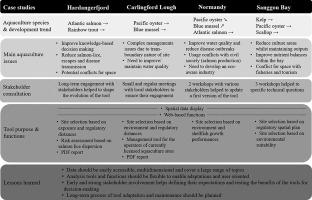
Abstract The development of spatial planning and management approaches is required to increase the space available for aquaculture production and to support the increasing global demand for food resources. During a European funded project, a large consultation exercise highlighted that stakeholder involvement is a necessity for successful planning and must be a continuous process as part of the development of a decision-making tool. In this study we present a decision support tool built on a web based dynamic interface to Geographic Information Systems which facilitates access to information related to site selection, environmental interactions and management in aquaculture. It is derived from the AkvaVis concept and uses interactive functions that instantly display the results of spatial parameters chosen by the user. We adapted the tool for use within four case studies which deal with very different scales of aquaculture and issues related to aquaculture in four different countries. The key strengths of our tools relate to their capacity to manage and display spatial data from different sources in a transparent way, the ability to use and display a series of built-in indicators, and the long-term development potential made possible by the maintenance strategy of the tools, services and data depository. Consultations and meetings provided an accurate view of stakeholder expectations as well as feedback on the tool development and applicability, therefore helping the tool to meet the prerequisite for operational decision-making tools.
中文翻译:

用于水产养殖综合规划和管理的基于网络的公共决策支持工具
摘要 空间规划和管理方法的发展需要增加可用于水产养殖生产的空间并支持全球对粮食资源日益增长的需求。在欧洲资助的项目中,一项大型咨询活动强调利益相关者的参与是成功规划的必要条件,并且必须是一个持续的过程,作为开发决策工具的一部分。在这项研究中,我们提出了一种决策支持工具,该工具建立在基于 Web 的地理信息系统动态界面上,该工具有助于访问与选址、环境相互作用和水产养殖管理相关的信息。它源自 AkvaVis 概念,并使用交互式功能即时显示用户选择的空间参数的结果。我们调整了该工具以用于四个案例研究,这些案例研究涉及四个不同国家的不同规模的水产养殖和与水产养殖相关的问题。我们工具的主要优势在于它们以透明的方式管理和显示来自不同来源的空间数据的能力、使用和显示一系列内置指标的能力以及维护带来的长期发展潜力工具、服务和数据存储的策略。磋商和会议提供了利益相关者期望的准确视图以及对工具开发和适用性的反馈,因此有助于工具满足运营决策工具的先决条件。
更新日期:2020-11-01
中文翻译:
用于水产养殖综合规划和管理的基于网络的公共决策支持工具
摘要 空间规划和管理方法的发展需要增加可用于水产养殖生产的空间并支持全球对粮食资源日益增长的需求。在欧洲资助的项目中,一项大型咨询活动强调利益相关者的参与是成功规划的必要条件,并且必须是一个持续的过程,作为开发决策工具的一部分。在这项研究中,我们提出了一种决策支持工具,该工具建立在基于 Web 的地理信息系统动态界面上,该工具有助于访问与选址、环境相互作用和水产养殖管理相关的信息。它源自 AkvaVis 概念,并使用交互式功能即时显示用户选择的空间参数的结果。我们调整了该工具以用于四个案例研究,这些案例研究涉及四个不同国家的不同规模的水产养殖和与水产养殖相关的问题。我们工具的主要优势在于它们以透明的方式管理和显示来自不同来源的空间数据的能力、使用和显示一系列内置指标的能力以及维护带来的长期发展潜力工具、服务和数据存储的策略。磋商和会议提供了利益相关者期望的准确视图以及对工具开发和适用性的反馈,因此有助于工具满足运营决策工具的先决条件。


 京公网安备 11010802027423号