当前位置:
X-MOL 学术
›
Tectonophysics
›
论文详情
Our official English website, www.x-mol.net, welcomes your
feedback! (Note: you will need to create a separate account there.)
Crustal seismogenic structures and deformation styles along the Longmen Shan Fault belt in the eastern Tibetan Plateau inferred from ambient noise tomography
Tectonophysics ( IF 2.7 ) Pub Date : 2021-01-01 , DOI: 10.1016/j.tecto.2020.228689 Mei Feng , Hui Qian , James Mechie , Meijian An , Haibing Li , Guangqi Xue , Heping Su , Xiang Cui
Tectonophysics ( IF 2.7 ) Pub Date : 2021-01-01 , DOI: 10.1016/j.tecto.2020.228689 Mei Feng , Hui Qian , James Mechie , Meijian An , Haibing Li , Guangqi Xue , Heping Su , Xiang Cui
|
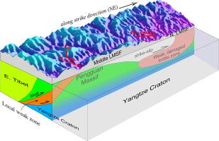
Abstract A seismic array comprising 80 broadband stations with ~10–20 km inter-station distances was deployed along the Longmen Shan fault belt (LMSF), the eastern boundary of the Tibetan Plateau. The recorded ambient noise data provided densely distributed inter-station cross-correlated surface waves. A new 3-D crustal S-wave velocity model for the LMSF was constructed by carrying out ambient noise tomography. The inverted model strongly improved data fitting and decreased data misfit compared to the reference (initial) model. The model highlights several crustal structure features. The Baoxing and Pengguan Massifs on the mountain side of the southern-to-middle LMSF exhibit relatively high crustal velocities, probably indicating strong crust. Low crustal velocities that may reflect weak, deformable brittle crust, exist mainly beneath the middle-to-northern segment of the LMSF and partly around the periphery of the Baoxing and Pengguan Massifs in its southern-to-middle segment. Two SW dipping low-velocity (weak) belts approximately perpendicular to the LMSF are imaged respectively around the Wenchuan-earthquake hypocenter in the south and Beichuan in the north. The low velocities in the two belts may focus movement of the eastern Tibetan Plateau relative to the Sichuan Basin (Yangtze Craton), and the uplift of the Tibetan Plateau over long time periods. Based on the velocity and tectonic structures, the young, high topography and thickened crust but low GPS shortening rates around the southern-to-middle LMSF may be due to the dominant effect of vertical crustal deformation caused by the existence of the strong Baoxing and Pengguan Massifs. This would then be in contrast to the characteristic lateral movements due to ductile crustal flow or weak, deformable brittle crust typical of the middle-to-northern LMSF.
中文翻译:

环境噪声层析成像推断青藏高原东部龙门山断裂带地壳孕震构造及变形方式
摘要 沿青藏高原东部边界龙门山断裂带 (LMSF) 部署了一个由 80 个宽带台站组成的地震阵列,台站间距离约为 10-20 公里。记录的环境噪声数据提供了密集分布的站间互相关表面波。通过进行环境噪声断层扫描,构建了新的 LMSF 3-D 地壳 S 波速度模型。与参考(初始)模型相比,倒置模型极大地改善了数据拟合并减少了数据错配。该模型突出了几个地壳结构特征。LMSF南-中山侧的宝兴和彭关地块表现出相对较高的地壳速度,可能表明强地壳。低地壳速度可能反映了脆弱的、可变形的脆性地壳,主要存在于LMSF中北段之下,部分分布在宝兴地块和彭关地块的南中段外围。分别在南部的汶川地震震源和北部的北川附近成像了两条近似垂直于LMSF的西南倾斜低速(弱)带。两条带的低速可能是青藏高原东部相对于四川盆地(长江克拉通)的运动和青藏高原长期隆升的集中。从速度和构造结构来看,南中LMSF周围年轻、地势高、地壳增厚但GPS缩短率低可能是由于强宝兴和彭关的存在导致地壳垂直变形的主导作用。地块。
更新日期:2021-01-01
中文翻译:
环境噪声层析成像推断青藏高原东部龙门山断裂带地壳孕震构造及变形方式
摘要 沿青藏高原东部边界龙门山断裂带 (LMSF) 部署了一个由 80 个宽带台站组成的地震阵列,台站间距离约为 10-20 公里。记录的环境噪声数据提供了密集分布的站间互相关表面波。通过进行环境噪声断层扫描,构建了新的 LMSF 3-D 地壳 S 波速度模型。与参考(初始)模型相比,倒置模型极大地改善了数据拟合并减少了数据错配。该模型突出了几个地壳结构特征。LMSF南-中山侧的宝兴和彭关地块表现出相对较高的地壳速度,可能表明强地壳。低地壳速度可能反映了脆弱的、可变形的脆性地壳,主要存在于LMSF中北段之下,部分分布在宝兴地块和彭关地块的南中段外围。分别在南部的汶川地震震源和北部的北川附近成像了两条近似垂直于LMSF的西南倾斜低速(弱)带。两条带的低速可能是青藏高原东部相对于四川盆地(长江克拉通)的运动和青藏高原长期隆升的集中。从速度和构造结构来看,南中LMSF周围年轻、地势高、地壳增厚但GPS缩短率低可能是由于强宝兴和彭关的存在导致地壳垂直变形的主导作用。地块。


 京公网安备 11010802027423号