Ecological Indicators ( IF 6.9 ) Pub Date : 2020-11-23 , DOI: 10.1016/j.ecolind.2020.107179 Santanu Mallik , Umesh Mishra , Niladri Paul
|
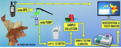
In the last few decades, overexploitation and poor management of groundwater have exposed its resources to undue risk, which makes the assessment of groundwater quality and determining its suitability extremely crucial. The current study has been undertaken with an aim to analyze groundwater suitability for drinking by utilizing fuzzy logic in the geographical Information System (GIS) platform. Water samples were analyzed for various physicochemical parameters collected from different sampling stations of the Agartala Municipality. Principal Component Analysis (PCA) and Ordinary kriging (OK) were used for variable reduction and mapping of the physicochemical parameters. The best fuzzy overlay operator for the groundwater suitability map was determined based on correlation coefficient values between water quality index map and suitability maps. The results of the correlation analysis show a high positive correlation between Cl− with EC (Electrical conductivity) and pH with HCO3−.The groundwater of the study area is mostly acidic, with elevated iron levels along with pockets of high nitrate concentration. Fuzzy GAMMA (0.9) overlay method was selected as the best overlay operation for suitability analysis. Suitability analysis results revealed that 24.6%, 28.6%, 46.7%, of the total surface area is unsuitable, moderately suitable, and suitable respectively. This study demonstrates the capability of fuzzy logic integrated with the GIS platform to determine the groundwater suitability for drinking. The proposed methodology can be exploited as a comprehensive tool for any other suitability analysis.
中文翻译:
基于GIS的饮用水地下水适宜性分析。
在过去的几十年中,地下水的过度开发和管理不善使地下水资源遭受了不适当的风险,这使得评估地下水质量和确定其适用性极为关键。当前的研究旨在通过利用地理信息系统(GIS)平台中的模糊逻辑来分析地下水是否适合饮用。分析了从阿加尔塔拉市不同采样站采集的水样的各种理化参数。使用主成分分析(PCA)和普通克里金法(OK)进行可变还原和理化参数映射。根据水质指标图与适用性图之间的相关系数值,确定了适用于地下水适用性图的最佳模糊叠加算子。−带有EC(电导率)和pH值(带有HCO 3 −)。研究区域的地下水大多数是酸性的,铁含量升高,硝酸盐浓度高。选择模糊GAMMA(0.9)重叠方法作为适合性分析的最佳重叠操作。适宜性分析结果表明,总表面积的24.6%,28.6%,46.7%分别不合适,适度合适和合适。这项研究表明,将模糊逻辑与GIS平台集成在一起,可以确定地下水是否适合饮用。所提议的方法可以用作任何其他适用性分析的综合工具。


 京公网安备 11010802027423号