当前位置:
X-MOL 学术
›
Remote Sens. Ecol. Conserv.
›
论文详情
Our official English website, www.x-mol.net, welcomes your
feedback! (Note: you will need to create a separate account there.)
Monitoring spring phenology of individual tree crowns using drone-acquired NDVI data
Remote Sensing in Ecology and Conservation ( IF 3.9 ) Pub Date : 2020-11-21 , DOI: 10.1002/rse2.184 Dominic Fawcett 1 , Jonathan Bennie 2 , Karen Anderson 1
Remote Sensing in Ecology and Conservation ( IF 3.9 ) Pub Date : 2020-11-21 , DOI: 10.1002/rse2.184 Dominic Fawcett 1 , Jonathan Bennie 2 , Karen Anderson 1
Affiliation

|
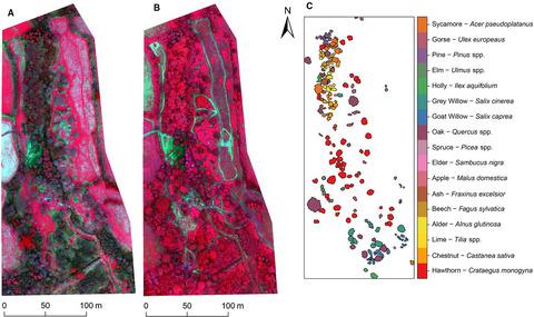
Quantifying the timing of vegetation phenology is critical for monitoring and modelling ecosystem responses to environmental change. Phenological processes have been studied from landscape to global scales using Earth observing satellite data, and at local scale by in situ surveys of individual plants. Now, data acquired from multi-spectral sensors on drone platforms provide flexible opportunities for monitoring phenology from individual plants to small ecosystem scales efficiently, allowing community and species level information to be derived. We captured a time-series of drone-acquired normalized difference vegetation index (NDVI) data with a multi-spectral sensor (Parrot Sequoia, (Parrot, France)) over a highly heterogeneous ecosystem in Cornwall, UK, during a period of spring green-up. We monitored NDVI trajectories at the individual crown and species’ level. For deciduous crowns, we derived metrics representative of spring phenological stages: Start-of-spring (SOS), middle-of-spring green-up (MOG) and start-of-peak greenness (SOP) using a logistic function. While the exact timing of SOS, MOG and SOP appeared susceptible to understorey effects and saturation of the NDVI, relative timing of green-up for a subset of species was plausible in relation to phenological observations from an extended geographic region and in situ plant area index (PAI) measurements. In evergreen vegetation (Pinus spp.) subtle changes were also detected through the growing season. The impact of illumination differences was analysed for image pairs during leaf-off and leaf-on conditions. While significant, these effects were small (mean absolute NDVI deviation of up to 0.034 for leaf-off, 0.013 for leaf-on conditions), meaning that data captured under both constant direct and diffuse irradiance conditions can be used together and that cloudy conditions should not lead to data gaps. We conclude that the capability of drone-mounted multi-spectral instruments for spatio-temporal characterization of crown-level phenology shows great promise for improving the understanding of intra- and inter-species differences in strategy, and offers an efficient means of doing so over areas of a few hectares.
中文翻译:

使用无人机获取的 NDVI 数据监测单个树冠的春季物候
量化植被物候的时间对于监测和模拟生态系统对环境变化的反应至关重要。已使用地球观测卫星数据研究了从景观到全球尺度的物候过程,并通过原位在局部尺度上进行了研究。个别植物的调查。现在,从无人机平台上的多光谱传感器获取的数据为有效监测从单个植物到小生态系统规模的物候学提供了灵活的机会,从而能够获得群落和物种水平的信息。在春绿期间,我们使用多光谱传感器(Parrot Sequoia,(Parrot,法国))在英国康沃尔的高度异质生态系统上捕获了无人机获取的归一化差异植被指数 (NDVI) 数据的时间序列-向上。我们监测了个体冠和物种水平的 NDVI 轨迹。对于落叶树冠,我们使用逻辑函数导出了代表春季物候阶段的指标:春季开始 (SOS)、春季中期绿化 (MOG) 和峰值绿化开始 (SOP)。虽然 SOS 的确切时间,原位植物面积指数 (PAI) 测量。在常绿植被(松spp.) 在整个生长季节也检测到细微的变化。在叶子关闭和叶子打开条件下,对图像对的光照差异的影响进行了分析。虽然显着,但这些影响很小(叶脱落条件下的平均绝对 NDVI 偏差高达 0.034,叶上条件下为 0.013),这意味着在恒定的直接和漫射辐照度条件下捕获的数据可以一起使用,并且多云条件下应该不会导致数据空白。我们得出的结论是,无人机安装的多光谱仪器用于冠层物候学时空表征的能力显示出提高对物种内和物种间战略差异的理解的巨大希望,并提供了一种有效的手段几公顷的面积。
更新日期:2020-11-21
中文翻译:

使用无人机获取的 NDVI 数据监测单个树冠的春季物候
量化植被物候的时间对于监测和模拟生态系统对环境变化的反应至关重要。已使用地球观测卫星数据研究了从景观到全球尺度的物候过程,并通过原位在局部尺度上进行了研究。个别植物的调查。现在,从无人机平台上的多光谱传感器获取的数据为有效监测从单个植物到小生态系统规模的物候学提供了灵活的机会,从而能够获得群落和物种水平的信息。在春绿期间,我们使用多光谱传感器(Parrot Sequoia,(Parrot,法国))在英国康沃尔的高度异质生态系统上捕获了无人机获取的归一化差异植被指数 (NDVI) 数据的时间序列-向上。我们监测了个体冠和物种水平的 NDVI 轨迹。对于落叶树冠,我们使用逻辑函数导出了代表春季物候阶段的指标:春季开始 (SOS)、春季中期绿化 (MOG) 和峰值绿化开始 (SOP)。虽然 SOS 的确切时间,原位植物面积指数 (PAI) 测量。在常绿植被(松spp.) 在整个生长季节也检测到细微的变化。在叶子关闭和叶子打开条件下,对图像对的光照差异的影响进行了分析。虽然显着,但这些影响很小(叶脱落条件下的平均绝对 NDVI 偏差高达 0.034,叶上条件下为 0.013),这意味着在恒定的直接和漫射辐照度条件下捕获的数据可以一起使用,并且多云条件下应该不会导致数据空白。我们得出的结论是,无人机安装的多光谱仪器用于冠层物候学时空表征的能力显示出提高对物种内和物种间战略差异的理解的巨大希望,并提供了一种有效的手段几公顷的面积。


 京公网安备 11010802027423号