ISPRS Journal of Photogrammetry and Remote Sensing ( IF 10.6 ) Pub Date : 2020-11-20 , DOI: 10.1016/j.isprsjprs.2020.10.018 Yousra Hamrouni , Eric Paillassa , Véronique Chéret , Claude Monteil , David Sheeren
|
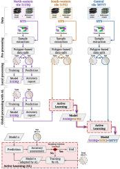
Reliable estimates of poplar plantations area are not available at the French national scale due to the unsuitability and low update rate of existing forest databases for this short-rotation species. While supervised classification methods have been shown to be highly accurate in mapping forest cover from remotely sensed images, their performance depends to a great extent on the labelled samples used to build the models. In addition to their high acquisition cost, such samples are often scarce and not fully representative of the variability in class distributions. Consequently, when classification models are applied to large areas with high intra-class variance, they generally yield poor accuracies because of data shift issues. In this paper, we propose the use of active learning to efficiently adapt a classifier trained on a source image to spatially distinct target images with minimal labelling effort and without sacrificing the classification performance. The adaptation consists in actively adding to the initial local model new relevant training samples from other areas in a cascade that iteratively improves the generalisation capabilities of the classifier leading to a global model tailored to these different areas. This active selection relies on uncertainty sampling to directly focus on the most informative pixels for which the algorithm is the least certain of their class labels. Experiments conducted on Sentinel-2 time series revealed their high capacity to identify poplar plantations at a local scale with an average F-score ranging from 89.5% to 99.3%. For large area adaptation, the results showed that when the same number of training samples was used, active learning outperformed random sampling by up to 5% of the overall accuracy and up to 12% of the class F-score. Additionally, and depending on the class considered, the random sampling model required up to 50% more samples to achieve the same performance of an active learning-based model. Moreover, the results demonstrate the suitability of the derived global model to accurately map poplar plantations among other tree species with overall accuracy values up to 14% higher than those obtained with local models. The proposed approach paves the way for a national scale mapping in an operational context.
中文翻译:
从本地到全球:使用Sentinel-2在全国范围内绘制杨树人工林的基于迁移学习的方法
在法国国家范围内,尚无可靠的估计的杨树人工林面积的估计,原因是该短轮伐树种的现有森林数据库不合适且更新率较低。尽管已证明监督分类方法在从遥感影像中绘制森林覆盖图时非常准确,但其性能在很大程度上取决于用于构建模型的标记样本。除了其高昂的购置成本外,此类样本通常很稀少,不能完全代表类别分布的可变性。因此,将分类模型应用于具有较高组内差异的较大区域时,由于数据移位问题,它们通常产生较差的准确性。在本文中,我们建议使用主动学习,以最小的标记工作量而又不牺牲分类性能地有效地使在源图像上训练的分类器适应空间上不同的目标图像。适应包括将来自其他区域的新的相关训练样本积极地添加到初始局部模型中,从而逐步提高分类器的泛化能力,从而为这些不同区域量身定制全局模型。这种主动选择依赖于不确定性采样来直接关注算法信息最不确定的类别信息最丰富的像素。在Sentinel-2时间序列上进行的实验表明,它们具有很高的识别本地规模杨树人工林的能力,其平均F值范围为89.5%至99.3%。对于大面积适应,结果表明,当使用相同数量的训练样本时,主动学习的效果优于随机抽样的总准确率的5%和F类分数的12%。此外,根据所考虑的类别,随机采样模型最多需要多50%的采样才能实现与基于主动学习的模型相同的性能。此外,结果表明,导出的全局模型适用于在其他树种之间准确绘制杨树人工林的地图,其总体精度值比使用局部模型获得的树高了14%。拟议的方法为在业务范围内进行国家规模测绘铺平了道路。主动学习的表现优于随机抽样,其总准确率最高可达5%,而F类成绩的最高可达12%。此外,根据所考虑的类别,随机采样模型最多需要多50%的采样才能实现与基于主动学习的模型相同的性能。此外,结果表明,所导出的全局模型适用于在其他树种之间准确绘制杨树人工林的地图,其总体精度值比使用局部模型获得的树高了14%。拟议的方法为在业务范围内进行国家规模测绘铺平了道路。主动学习的表现优于随机抽样,其总准确率最高可达5%,而F类成绩的最高可达12%。此外,根据所考虑的类别,随机采样模型最多需要多50%的样本才能实现基于主动学习的模型的相同性能。此外,结果表明,所导出的全局模型适用于在其他树种之间准确绘制杨树人工林的地图,其总体精度值比使用局部模型获得的树高了14%。拟议的方法为在业务范围内进行国家规模测绘铺平了道路。结果表明,所导出的全局模型适用于在其他树种之间准确绘制杨树人工林的地图,其总体精度值比使用局部模型获得的树高了14%。拟议的方法为在业务范围内进行国家规模测绘铺平了道路。结果表明,所导出的全局模型适用于在其他树种之间准确绘制杨树人工林的地图,其总体精度值比使用局部模型获得的树高了14%。拟议的方法为在业务范围内进行国家规模测绘铺平了道路。


 京公网安备 11010802027423号