当前位置:
X-MOL 学术
›
Remote Sens. Ecol. Conserv.
›
论文详情
Our official English website, www.x-mol.net, welcomes your
feedback! (Note: you will need to create a separate account there.)
Regional-scale forest restoration effects on ecosystem resiliency to drought: a synthesis of vegetation and moisture trends on Google Earth Engine
Remote Sensing in Ecology and Conservation ( IF 3.9 ) Pub Date : 2020-11-19 , DOI: 10.1002/rse2.186 Temuulen Sankey 1 , Adam Belmonte 1 , Richard Massey 1 , Jackson Leonard 2
Remote Sensing in Ecology and Conservation ( IF 3.9 ) Pub Date : 2020-11-19 , DOI: 10.1002/rse2.186 Temuulen Sankey 1 , Adam Belmonte 1 , Richard Massey 1 , Jackson Leonard 2
Affiliation
|
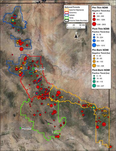
Large-scale changes in forest structure and ecological function throughout western North America have led to increased frequency, size, and severity of wildfires. The US Forest Service is implementing state-wide forest restoration initiatives to reduce wildfire hazards and improve forest health. We provide a synthesis of pre- and post-treatment forest vegetation and ecosystem moisture trends between 1990 and 2017 in Arizona, the first US state where the initiative has implemented a variety of thinning and burning methods in over 1,200 polygon areas across 3.5 million ha. Using 4,426 Landsat satellite images on Google Earth Engine, we calculated normalized difference moisture index (NDMI), normalized difference water index (NDWI), and normalized difference vegetation index (NDVI) to create dense time-series datasets. The indices and 1990-2017 annual total precipitation dataset were then examined using a Mann–Kendall tau test to identify statistically significant upward and downward trends for each pixel. Our results indicate that much of the study region were experiencing drought conditions prior to restoration treatments and NDVI values were significantly decreasing, especially during the dry spring season. However, both NDMI and NDWI trends indicate that the forest restoration treatments have contributed to increased total ecosystem moisture, while precipitation in the post-treatment period exhibit stable trends. Forest restoration treatments appear to have improved the overall forest health and resiliency to drought, especially during the dry spring season, when forests are most vulnerable to water stress and wildfire risks. Our results of the spatial patterns and long-term trends in these variables can inform the currently ongoing and future restoration treatments to better target the treatment strategy across the southwestern USA. Google Earth Engine enabled our synthesis of these long-term trends over the large region and will enhance our continued monitoring in the coming decade.
中文翻译:

区域尺度森林恢复对生态系统抗旱能力的影响:谷歌地球引擎上植被和水分趋势的综合
北美西部森林结构和生态功能的大规模变化导致野火的频率、规模和严重程度增加。美国林务局正在实施全州范围的森林恢复计划,以减少野火危害并改善森林健康。我们提供了 1990 年至 2017 年在亚利桑那州的预处理和后处理森林植被和生态系统水分趋势的综合,这是该倡议在 350 万公顷的 1,200 多个多边形区域实施各种间伐和燃烧方法的美国第一个州。使用 Google Earth Engine 上的 4,426 幅 Landsat 卫星图像,我们计算了归一化差异水分指数 (NDMI)、归一化差异水分指数 (NDWI) 和归一化差异植被指数 (NDVI),以创建密集的时间序列数据集。然后使用 Mann-Kendall tau 检验检查指数和 1990-2017 年年度总降水量数据集,以确定每个像素的统计上显着的上升和下降趋势。我们的结果表明,大部分研究区域在恢复处理之前经历了干旱条件,NDVI 值显着下降,尤其是在干燥的春季。然而,NDMI 和 NDWI 趋势都表明,森林恢复处理有助于增加生态系统总水分,而处理后时期的降水则表现出稳定的趋势。森林恢复治疗似乎改善了森林的整体健康状况和抗旱能力,尤其是在干燥的春季,此时森林最容易受到水资源压力和野火风险的影响。我们对这些变量的空间模式和长期趋势的结果可以为当前正在进行和未来的恢复处理提供信息,以更好地针对美国西南部的处理策略。谷歌地球引擎使我们能够综合这些大区域的长期趋势,并将加强我们在未来十年的持续监测。
更新日期:2020-11-19
中文翻译:
区域尺度森林恢复对生态系统抗旱能力的影响:谷歌地球引擎上植被和水分趋势的综合
北美西部森林结构和生态功能的大规模变化导致野火的频率、规模和严重程度增加。美国林务局正在实施全州范围的森林恢复计划,以减少野火危害并改善森林健康。我们提供了 1990 年至 2017 年在亚利桑那州的预处理和后处理森林植被和生态系统水分趋势的综合,这是该倡议在 350 万公顷的 1,200 多个多边形区域实施各种间伐和燃烧方法的美国第一个州。使用 Google Earth Engine 上的 4,426 幅 Landsat 卫星图像,我们计算了归一化差异水分指数 (NDMI)、归一化差异水分指数 (NDWI) 和归一化差异植被指数 (NDVI),以创建密集的时间序列数据集。然后使用 Mann-Kendall tau 检验检查指数和 1990-2017 年年度总降水量数据集,以确定每个像素的统计上显着的上升和下降趋势。我们的结果表明,大部分研究区域在恢复处理之前经历了干旱条件,NDVI 值显着下降,尤其是在干燥的春季。然而,NDMI 和 NDWI 趋势都表明,森林恢复处理有助于增加生态系统总水分,而处理后时期的降水则表现出稳定的趋势。森林恢复治疗似乎改善了森林的整体健康状况和抗旱能力,尤其是在干燥的春季,此时森林最容易受到水资源压力和野火风险的影响。我们对这些变量的空间模式和长期趋势的结果可以为当前正在进行和未来的恢复处理提供信息,以更好地针对美国西南部的处理策略。谷歌地球引擎使我们能够综合这些大区域的长期趋势,并将加强我们在未来十年的持续监测。


 京公网安备 11010802027423号