当前位置:
X-MOL 学术
›
Biosyst. Eng.
›
论文详情
Our official English website, www.x-mol.net, welcomes your
feedback! (Note: you will need to create a separate account there.)
Mapping crop stand count and planting uniformity using high resolution imagery in a maize crop
Biosystems Engineering ( IF 4.4 ) Pub Date : 2020-12-01 , DOI: 10.1016/j.biosystemseng.2020.10.013 Alimohammad Shirzadifar , Mohammadmehdi Maharlooei , Sreekala G. Bajwa , Peter G. Oduor , John F. Nowatzki
Biosystems Engineering ( IF 4.4 ) Pub Date : 2020-12-01 , DOI: 10.1016/j.biosystemseng.2020.10.013 Alimohammad Shirzadifar , Mohammadmehdi Maharlooei , Sreekala G. Bajwa , Peter G. Oduor , John F. Nowatzki
|
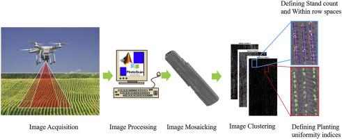
The accurate evaluation of maize plants’ uniformity aligned with an effective improvement in germination and biomass assessment is of paramount importance for farmers. Early detection of stand count provides details on uneven emergence for farmers to make a prompt decision for replanting and applying proper agricultural inputs at defective zones. However, conventional, ground-based stand count methods are costly, time-intensive, and the accuracy of the counting method heavily depends on the selected area. This study focuses on validating the potential application of high resolution unmanned aerial vehicle (UAV) images for detecting the total number of maize plants and stand uniformity soon after maize germination. A field experiment was conducted to evaluate proper image processing algorithm for detecting the maize crop and calculating the distance between adjacent maize plants within a row. In the mosaicked images, the pixels including maize plants were segmented using two methods including excess green index (EXG) method and k-means clustering-segmentation technique. The mean accuracy using EXG method was 46%, however, the k-means clustering-segmentation method satisfactorily identified plants with mean accuracy of 91% in the field. The planting uniformity of maize plants was also evaluated based on three indices including miss index, multiple index, and coefficient of precision. Results showed that plant stand assessment using mosaicked images was closer to the values set on the planting machine. The marginal discrepancy between estimated and observed plant stand count and other indices confirms the high accuracy of UAV mosaicked images in plant density estimation for growers to make appropriate management decisions.
中文翻译:

在玉米作物中使用高分辨率图像绘制作物林分计数和种植均匀度
玉米植株均匀性的准确评估以及发芽和生物量评估的有效改进对农民来说至关重要。对林分计数的早期检测为农民提供了出苗不均的详细信息,以便迅速决定在缺陷区域重新种植和应用适当的农业投入。然而,传统的基于地面的林分计数方法成本高、耗时长,并且计数方法的准确性在很大程度上取决于所选区域。本研究的重点是验证高分辨率无人机 (UAV) 图像在玉米发芽后不久检测玉米植株总数和林分均匀度的潜在应用。进行了田间试验以评估用于检测玉米作物和计算行内相邻玉米植物之间距离的适当图像处理算法。在镶嵌图像中,包括玉米植株的像素使用两种方法进行分割,包括过量绿色指数(EXG)方法和k-means聚类分割技术。使用 EXG 方法的平均准确率为 46%,然而,k-means 聚类分割方法令人满意地识别植物,田间平均准确率为 91%。玉米植株的种植均匀度也基于三个指标进行评价,包括未命中指数、多重指数和精确系数。结果表明,使用镶嵌图像进行的植物林分评估更接近种植机上设置的值。
更新日期:2020-12-01
中文翻译:
在玉米作物中使用高分辨率图像绘制作物林分计数和种植均匀度
玉米植株均匀性的准确评估以及发芽和生物量评估的有效改进对农民来说至关重要。对林分计数的早期检测为农民提供了出苗不均的详细信息,以便迅速决定在缺陷区域重新种植和应用适当的农业投入。然而,传统的基于地面的林分计数方法成本高、耗时长,并且计数方法的准确性在很大程度上取决于所选区域。本研究的重点是验证高分辨率无人机 (UAV) 图像在玉米发芽后不久检测玉米植株总数和林分均匀度的潜在应用。进行了田间试验以评估用于检测玉米作物和计算行内相邻玉米植物之间距离的适当图像处理算法。在镶嵌图像中,包括玉米植株的像素使用两种方法进行分割,包括过量绿色指数(EXG)方法和k-means聚类分割技术。使用 EXG 方法的平均准确率为 46%,然而,k-means 聚类分割方法令人满意地识别植物,田间平均准确率为 91%。玉米植株的种植均匀度也基于三个指标进行评价,包括未命中指数、多重指数和精确系数。结果表明,使用镶嵌图像进行的植物林分评估更接近种植机上设置的值。


 京公网安备 11010802027423号