Geoscience Frontiers ( IF 8.5 ) Pub Date : 2020-11-07 , DOI: 10.1016/j.gsf.2020.09.022 Mahfuzur Rahman , Ningsheng Chen , Md Monirul Islam , Ashraf Dewan , Hamid Reza Pourghasemi , Rana Muhammad Ali Washakh , Nirdesh Nepal , Shufeng Tian , Hamid Faiz , Mehtab Alam , Naveed Ahmed
|
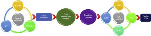
This work developed models to identify optimal spatial distribution of emergency evacuation centers (EECs) such as schools, colleges, hospitals, and fire stations to improve flood emergency planning in the Sylhet region of northeastern Bangladesh. The use of location-allocation models (LAMs) for evacuation in regard to flood victims is essential to minimize disaster risk. In the first step, flood susceptibility maps were developed using machine learning models (MLMs), including: Levenberg–Marquardt back propagation (LM-BP) neural network and decision trees (DT) and multi-criteria decision making (MCDM) method. Performance of the MLMs and MCDM techniques were assessed considering the area under the receiver operating characteristic (AUROC) curve. Mathematical approaches in a GIS for four well-known LAM problems affecting emergency rescue time are proposed: maximal covering location problem (MCLP), the maximize attendance (MA), p-median problem (PMP), and the location set covering problem (LSCP). The results showed that existing EECs were not optimally distributed, and that some areas were not adequately served by EECs (i.e., not all demand points could be reached within a 60-min travel time). We concluded that the proposed models can be used to improve planning of the distribution of EECs, and that application of the models could contribute to reducing human casualties, property losses, and improve emergency operation.
中文翻译:
基于GIS和遥感的紧急疏散规划的位置分配模型-以孟加拉国东北地区为例。
这项工作开发了模型,以识别紧急疏散中心(EEC)的最佳空间分布,例如学校,学院,医院和消防局,以改善孟加拉国东北部Sylhet地区的洪水应急计划。使用位置分配模型(LAM)疏散洪水灾民对于最大程度地减少灾难风险至关重要。第一步,使用机器学习模型(MLM)开发洪水敏感性图,包括:Levenberg-Marquardt反向传播(LM-BP)神经网络和决策树(DT)以及多准则决策(MCDM)方法。考虑到接收器工作特性(AUROC)曲线下方的面积,评估了MLM和MCDM技术的性能。提出了在GIS中针对影响紧急救援时间的四个著名LAM问题的数学方法:最大覆盖位置问题(MCLP),最大出勤率(MA),p中位数问题(PMP)和位置集覆盖问题(LSCP) )。结果表明,现有的EEC分布不是最佳的,并且EEC不能为某些区域提供足够的服务(即,并非在60分钟的旅行时间内就能满足所有需求点)。我们得出的结论是,提出的模型可用于改进EEC的分配规划,并且模型的应用可有助于减少人员伤亡,财产损失并改善紧急情况。结果表明,现有的EEC分布不是最佳的,并且EEC不能为某些区域提供足够的服务(即,并非在60分钟的旅行时间内就能满足所有需求点)。我们得出的结论是,提出的模型可用于改进EEC的分布规划,并且模型的应用可有助于减少人员伤亡,财产损失并改善紧急情况。结果表明,现有的EEC分布不是最佳的,并且EEC不能为某些区域提供足够的服务(即,并非在60分钟的旅行时间内就能满足所有需求点)。我们得出的结论是,提出的模型可用于改进EEC的分配规划,并且模型的应用可有助于减少人员伤亡,财产损失并改善紧急情况。


 京公网安备 11010802027423号