Clean Technologies and Environmental Policy ( IF 4.2 ) Pub Date : 2020-11-09 , DOI: 10.1007/s10098-020-01971-3 Belkhir Settou , Noureddine Settou , Abderrahmane Gouareh , Belkhir Negrou , Charafeddine Mokhtara , Djilali Messaoudi
|
Abstract
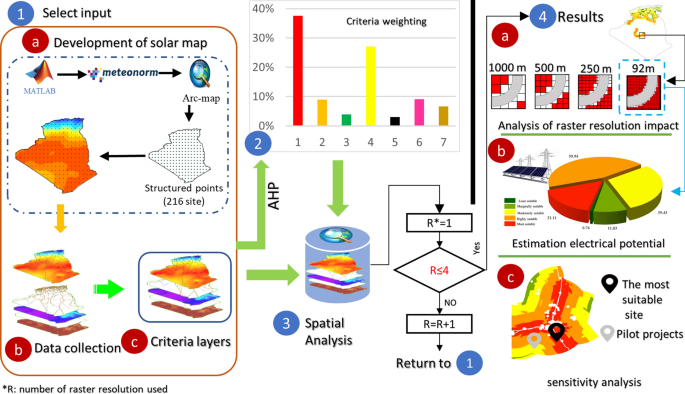
This paper proposes a site selection of large-scale grid-connected solar system in Algeria. A geographic information system-analytical hierarchy process (AHP) method was combined to identify and develop a high-resolution map of the most suitable sites for large-scale grid-connected solar system. A GIS database has been built for solar radiation, power grid, roads, cities, slope, land use and soil type. The data were gathered from different governmental organizations. However, a solar radiation map was developed using new approach. In order to test the impact of database raster resolution, the suitable zones are determined by performing a MCDM analysis using different (92 m, 250 m, 500 m and 1000 m) raster resolutions. The results show large improvements on solar radiation map compared to the previous work. A sensitivity analysis was done for three scenarios (AHP, equal weight, higher economic) which show that AHP method gives lager area of most suitable land. In addition, within raster resolution of 92 m, the most suitable zone for hosting large-scale grid-connected solar system represents 17% of the studied area, equivalent to more than 136 million GWh of energy produced. Moreover, more than 25,286 km2; was eliminated when using less resolution (1000 m) equivalent to 9.59 TWh, which demonstrated the high effect of raster resolution on the total power potential. The comparison of our results with those provided by renewable energy and energy efficiency development plan for PV projects indicated that 2 out of 21 projects are located inside of the optimal zone. For this reason, this work presents a helpful idea and significant results for policy makers to take decisions about implementing future solar projects.
Graphic abstract
中文翻译:
基于高分辨率地理信息系统-层次分析法的太阳能光伏电站选址方法:以阿尔及利亚为例
摘要
本文提出了阿尔及利亚大型并网太阳能系统的选址。地理信息系统-分析层次结构过程(AHP)方法结合在一起,可以识别和开发高分辨率的大规模并网太阳能系统站点的高分辨率地图。已建立了一个有关太阳辐射,电网,道路,城市,坡度,土地利用和土壤类型的GIS数据库。数据来自不同的政府组织。但是,使用新方法开发了太阳辐射图。为了测试数据库栅格分辨率的影响,可以通过使用不同的(92 m,250 m,500 m和1000 m)栅格分辨率执行MCDM分析来确定合适的区域。结果表明,与以前的工作相比,太阳辐射图有了很大的改进。对三种情况(AHP,等重,较高的经济性)进行了敏感性分析,结果表明,AHP方法给出了最合适土地的更大面积。此外,在92 m的光栅分辨率内,最适合容纳大型并网太阳能系统的区域占研究面积的17%,相当于产生的能量超过1.36亿吉瓦时。此外,超过25,286公里2 ; 当使用小于等于9.59 TWh的分辨率(1000 m)时就消除了这种现象,这证明了光栅分辨率对总电势的高影响。将我们的结果与光伏项目的可再生能源和能效发展计划提供的结果进行比较,结果表明21个项目中有2个位于最佳区域内。因此,这项工作为决策者提出了有关实施未来太阳能项目的决策的有益想法和重要成果。


 京公网安备 11010802027423号