Our official English website, www.x-mol.net, welcomes your
feedback! (Note: you will need to create a separate account there.)
Ecological niche models improve home range estimations
Journal of Zoology ( IF 1.9 ) Pub Date : 2020-11-06 , DOI: 10.1111/jzo.12844 N. Sillero 1 , R. dos Santos 2 , A. C. Teodoro 2, 3 , M. A. Carretero 4, 5
Journal of Zoology ( IF 1.9 ) Pub Date : 2020-11-06 , DOI: 10.1111/jzo.12844 N. Sillero 1 , R. dos Santos 2 , A. C. Teodoro 2, 3 , M. A. Carretero 4, 5
Affiliation
|
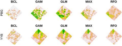
Home ranges in animals can be estimated by different methods like minimum convex polygons, characteristic hulls or kernels while correlative ecological niche models (ENMs) are commonly employed for forecasting species' ranges. However, ENMs can also model the distribution of individuals if environmental very high spatial resolution data are available. Indeed, remote sensing (RS) can provide images with pixel sizes of few centimetres. Here, we modelled the distribution of individual lizards (Podarcis bocagei) combining aerial‐like photographs recorded with a compact camera and a matrix of temperature/humidity data‐loggers to obtain several environmental layers with very high spatial resolution. We recorded lizards’ positions in a 20 × 20 m mesocosm with a high precision GPS device (~10 cm of error), multiple times per day throughout the whole period of daily activity. We built an orthophoto map (pixels of 20 cm2) from camera pictures, a digital surface model, and a land‐cover supervised classification map. We recreated climate‐like variables by combining data‐logger data. For each individual, we calculated the distance to males and females, excluding the focal lizard. We computed individual realized niche models with Bioclim, GAM, GLM, Maxent and random forest. Models attained a very high evaluation score in most cases. The most contributing variables were related to microclimate (isothermality, minimum temperature and humidity) and distance to conspecifics. Our very high spatial resolution models provided robust information on how space is used by each lizard. Correlative models can identify the most suitable areas inside the home range, similar to core areas estimated from kernel algorithms, but allowed better statistical inference. Overall, RS tools generated high‐quality environmental data, and when combined with ENMs, improved the robustness of the predictions on spatial patterns of small terrestrial animals.
中文翻译:

生态位模型可以改善房屋范围估计
可以通过不同的方法(例如最小凸多边形,特征性外壳或内核)来估计动物的居所范围,而通常使用相关生态位模型(ENM)来预测物种的范围。但是,如果可获得非常高的空间分辨率环境数据,ENM也可以对个人分布进行建模。实际上,遥感(RS)可以为图像提供几厘米的像素大小。在这里,我们对单个蜥蜴(Podarcis bocagei)的分布进行了建模。)结合使用小型相机记录的航空照片和温度/湿度数据记录仪矩阵,以获得具有很高空间分辨率的多个环境层。我们使用高精度GPS设备(误差约10厘米)在20×20 m的中观空间中记录了蜥蜴的位置,在整个日常活动中,每天进行多次。我们制作了一张正射影像图(像素为20 cm 2),相机图片,数字表面模型和有土地监督的分类图。通过结合数据记录器数据,我们重新创建了类似于气候的变量。对于每个个体,我们都计算了距雌雄的距离,不包括蜥蜴。我们使用Bioclim,GAM,GLM,Maxent和随机森林计算了单个实现的利基模型。在大多数情况下,模型均获得很高的评估分数。贡献最大的变量与微气候(等温,最低温度和湿度)和到特定物种的距离有关。我们非常高的空间分辨率模型提供了有关每个蜥蜴如何使用空间的可靠信息。相关模型可以识别原始范围内最合适的区域,类似于根据内核算法估算的核心区域,但可以进行更好的统计推断。总体,
更新日期:2020-11-06
中文翻译:
生态位模型可以改善房屋范围估计
可以通过不同的方法(例如最小凸多边形,特征性外壳或内核)来估计动物的居所范围,而通常使用相关生态位模型(ENM)来预测物种的范围。但是,如果可获得非常高的空间分辨率环境数据,ENM也可以对个人分布进行建模。实际上,遥感(RS)可以为图像提供几厘米的像素大小。在这里,我们对单个蜥蜴(Podarcis bocagei)的分布进行了建模。)结合使用小型相机记录的航空照片和温度/湿度数据记录仪矩阵,以获得具有很高空间分辨率的多个环境层。我们使用高精度GPS设备(误差约10厘米)在20×20 m的中观空间中记录了蜥蜴的位置,在整个日常活动中,每天进行多次。我们制作了一张正射影像图(像素为20 cm 2),相机图片,数字表面模型和有土地监督的分类图。通过结合数据记录器数据,我们重新创建了类似于气候的变量。对于每个个体,我们都计算了距雌雄的距离,不包括蜥蜴。我们使用Bioclim,GAM,GLM,Maxent和随机森林计算了单个实现的利基模型。在大多数情况下,模型均获得很高的评估分数。贡献最大的变量与微气候(等温,最低温度和湿度)和到特定物种的距离有关。我们非常高的空间分辨率模型提供了有关每个蜥蜴如何使用空间的可靠信息。相关模型可以识别原始范围内最合适的区域,类似于根据内核算法估算的核心区域,但可以进行更好的统计推断。总体,


 京公网安备 11010802027423号