Ecological Indicators ( IF 7.0 ) Pub Date : 2020-11-06 , DOI: 10.1016/j.ecolind.2020.107136 Shuangyun Peng , Shihua Li
|
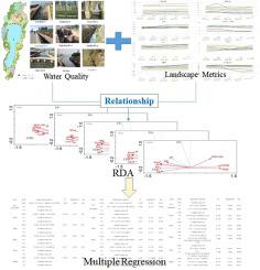
Understanding the scale relationship between landscape pattern and water quality is of great significance for improving water pollution and guiding the rational planning of land use in watersheds. At present, most existing studies take the watershed as a whole to explore the scale relationship between landscape pattern and water quality. Research on different types of pollution sources is still lacking. According to the characteristics of the pollution source in the watershed, the study of the multiscale effects of landscape pattern of different pollution source areas on water quality will help better the understanding of the impact of the surrounding landscape on the water quality of rivers, which is very important for local river management. In this study, a typical plateau lake basin, the Fuxian Lake basin, is taken as the research area, and the scale relationship between the surface landscape pattern and water quality in different pollution sources is taken as the research object. The redundancy analysis and multiple regression modeling are used to explore the impact of landscape pattern on water quality. The results show that the key landscape metrics that affect water quality indices in different pollution source areas and at different scales are quite different. Shannon's diversity index (SDI) had a significant effect on total phosphorus (TP) across the entire watershed. In the urban region, SDI and the mean shape index (MSI) have the greatest impact on chemical oxygen demand (COD) at the sub-watershed scale. In the phosphorus mining region, the landscape metrics SDI, Shannon's evenness index (SEI), and patch cohesion index (COHES) have significant effects on water quality, especially on TP. In the farmland and village region, the other 7 landscape metrics excluding the number of patches (NumP) become the leading indicators affecting water quality at different scales, among which total nitrogen (TN) has a particularly significant influence. Overall, the factor with the greatest effect on water quality was SDI in different pollution source areas. In terms of the scale effect, the landscape pattern has the strongest effect on water quality changes in the urban and phosphorus mining regions at sub-watershed scales, while in the farmland and village region, 300 m and 500 m are the areas where the landscape pattern has the strongest effect on water quality. These findings can provide decisional support for improving the water quality of lakes and rivers from the perspective of sustainable landscape management.
中文翻译:
不同污染源地景观格局与水质的尺度关系-以抚仙湖流域为例
了解景观格局与水质之间的尺度关系对改善水污染,指导流域土地合理利用具有重要意义。目前,大多数现有研究将分水岭作为一个整体,以探讨景观格局与水质之间的尺度关系。仍然缺乏对不同类型污染源的研究。根据流域内污染源的特点,研究不同污染源区景观格局对水质的多尺度影响,有助于更好地了解周围景观对河流水质的影响。对于当地河流管理非常重要。在这项研究中,以典型的高原湖泊流域-抚仙湖流域为研究区域,以不同污染源地表景观格局与水质的尺度关系为研究对象。冗余分析和多元回归模型用于探索景观格局对水质的影响。结果表明,影响不同污染源地区和规模的水质指标的关键景观指标差异很大。香农的多样性指数(SDI)对整个流域中的总磷(TP)有显着影响。在城市地区,SDI和平均形状指数(MSI)在该小流域尺度上对化学需氧量(COD)的影响最大。在磷矿开采区,景观指标SDI,香农的均匀度指数(SEI),斑块内聚指数(COHES)对水质,特别是对总磷有重要影响。在农田和乡村地区,除斑块数量(NumP)以外的其他7个景观指标成为影响不同规模水质的主要指标,其中总氮(TN)的影响尤其显着。总体而言,对水质影响最大的因素是不同污染源地区的SDI。就规模效应而言,景观格局对亚流域尺度上的城市和磷矿开采区的水质变化影响最大,而在农田和乡村地区,景观的面积为300 m和500 m模式对水质的影响最大。


 京公网安备 11010802027423号