当前位置:
X-MOL 学术
›
Remote Sens. Environ.
›
论文详情
Our official English website, www.x-mol.net, welcomes your
feedback! (Note: you will need to create a separate account there.)
Application of Landsat imagery for the investigation of wave breaking
Remote Sensing of Environment ( IF 11.1 ) Pub Date : 2021-02-01 , DOI: 10.1016/j.rse.2020.112144 A.A. Kubryakov , V.N. Kudryavtsev , S.V. Stanichny
Remote Sensing of Environment ( IF 11.1 ) Pub Date : 2021-02-01 , DOI: 10.1016/j.rse.2020.112144 A.A. Kubryakov , V.N. Kudryavtsev , S.V. Stanichny
|
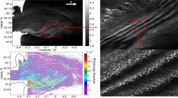
Abstract An algorithm for retrieving the fraction of the sea surface covered by whitecaps (W) from Landsat-8 satellite optical reflectance measurements in the near-infrared channel is described. The distribution of W derived from approximately 100 Landsat-8 scenes was compared with quasi-synchronous scatterometer measurements of wind speed (u10), which allowed us to obtain the W(u10) relation for large whitecaps from high-resolution satellite optical measurements. Further, we demonstrate the impact of various phenomena, including- internal waves, river plumes, bottom topography, atmospheric stability, ocean fronts, and mesoscale currents on whitecap coverage and its spatial variation in different areas of the ocean. These data are analysed using theoretical models, suggesting that whitecap coverage is a proxy of wave energy dissipation and reflects disturbances in the wind-wave energy balance caused by wave-current interactions and variable wind forcing due to changes in atmospheric stratification over ocean temperature fronts and the movement of wind-waves by surface currents relative to the atmospheric boundary layer.
中文翻译:

Landsat影像在波浪破碎调查中的应用
摘要 描述了一种从近红外通道中的 Landsat-8 卫星光学反射测量中检索被白浪 (W) 覆盖的海面部分的算法。来自大约 100 个 Landsat-8 场景的 W 分布与风速 (u10) 的准同步散射计测量值进行了比较,这使我们能够从高分辨率卫星光学测量中获得大型白浪的 W(u10) 关系。此外,我们展示了各种现象,包括内波、河流羽流、底部地形、大气稳定性、海洋前沿和中尺度海流对白帽覆盖率的影响及其在海洋不同区域的空间变化。这些数据使用理论模型进行分析,
更新日期:2021-02-01
中文翻译:
Landsat影像在波浪破碎调查中的应用
摘要 描述了一种从近红外通道中的 Landsat-8 卫星光学反射测量中检索被白浪 (W) 覆盖的海面部分的算法。来自大约 100 个 Landsat-8 场景的 W 分布与风速 (u10) 的准同步散射计测量值进行了比较,这使我们能够从高分辨率卫星光学测量中获得大型白浪的 W(u10) 关系。此外,我们展示了各种现象,包括内波、河流羽流、底部地形、大气稳定性、海洋前沿和中尺度海流对白帽覆盖率的影响及其在海洋不同区域的空间变化。这些数据使用理论模型进行分析,


 京公网安备 11010802027423号