当前位置:
X-MOL 学术
›
Planet. Space Sci.
›
论文详情
Our official English website, www.x-mol.net, welcomes your feedback! (Note: you will need to create a separate account there.)
Cartography of the Apollo 12 landing site from photogrammetric analysis of surface imagery
Planetary and Space Science ( IF 2.4 ) Pub Date : 2020-11-02 , DOI: 10.1016/j.pss.2020.105133 Vladislav-Veniamin Pustynski
Planetary and Space Science ( IF 2.4 ) Pub Date : 2020-11-02 , DOI: 10.1016/j.pss.2020.105133 Vladislav-Veniamin Pustynski
|
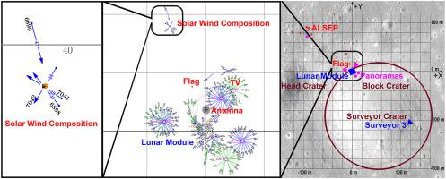
This work represents an Apollo 12 landing site photogrammetric study based on the lunar surface imagery. A set of 303 photographs taken by the crew was used to build up a 3D scene of the landing site. The mapped area includes the Lunar Module (LM) vicinity, Apollo Lunar Surface Experiments Package (ALSEP) deployment site, Surveyor 3 landing site, and Surveyor Crater. The camera station map was composed, locations of artifacts on the lunar surface were accurately determined. Orientations of the LM and Surveyor 3 were found to an accuracy of about 0.5–1°. The depth of Surveyor Crater was determined to an accuracy better than 1 m. The map and coordinates are in a good agreement with image data and Digital Terrain Models (DTMs) from Lunar Reconnaissance Orbiter (LRO).
中文翻译:

根据表面图像的摄影测量分析绘制阿波罗 12 号着陆点的地图
这项工作代表了基于月球表面图像的阿波罗 12 号着陆点摄影测量研究。机组人员拍摄的一组 303 张照片被用来构建着陆场的 3D 场景。绘制的区域包括登月舱 (LM) 附近、阿波罗月球表面实验包 (ALSEP) 部署地点、测量者 3 号着陆点和测量者陨石坑。绘制了相机站地图,准确确定了月球表面文物的位置。 LM 和 Surveyor 3 的方向精度约为 0.5–1°。 Surveyor Crater 的深度测定精度优于 1 米。地图和坐标与月球勘测轨道器 (LRO) 的图像数据和数字地形模型 (DTM) 非常吻合。
更新日期:2020-11-02
中文翻译:
根据表面图像的摄影测量分析绘制阿波罗 12 号着陆点的地图
这项工作代表了基于月球表面图像的阿波罗 12 号着陆点摄影测量研究。机组人员拍摄的一组 303 张照片被用来构建着陆场的 3D 场景。绘制的区域包括登月舱 (LM) 附近、阿波罗月球表面实验包 (ALSEP) 部署地点、测量者 3 号着陆点和测量者陨石坑。绘制了相机站地图,准确确定了月球表面文物的位置。 LM 和 Surveyor 3 的方向精度约为 0.5–1°。 Surveyor Crater 的深度测定精度优于 1 米。地图和坐标与月球勘测轨道器 (LRO) 的图像数据和数字地形模型 (DTM) 非常吻合。


 京公网安备 11010802027423号