Catena ( IF 5.4 ) Pub Date : 2020-10-24 , DOI: 10.1016/j.catena.2020.104958 Xi Wei , Sabine Sauvage , Sylvain Ouillon , Thi Phuong Quynh Le , Didier Orange , Marine Herrmann , José-Miguel Sanchez-Perez
|
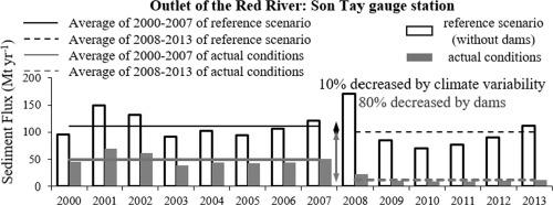
The Red River is an Asian river system strongly affected by global changes. This paper aims to characterize and quantify the suspended sediment flux (SF) over the basin under the influences of short-term climate variability and dam constructions. SF was evaluated at the outlets of main tributaries and along the main course of the Red River from 2000 to 2013 based on daily simulations from a modelling study. A reference scenario (without dams) was carried out to disentangle the impacts of short-term climate variability and damming by comparing to actual conditions. Without dams (reference scenario), the basin would generate 106.9 Mt yr−1 of SF to the downstream delta from 2000 to 2013, with a specific sediment yield (SSY) of 778.8 t km−2 yr−1. However, under the impacts of short-term climate variability and dams, the mean annual SSY decreased to 84.5 t km−2 yr−1. At the outlet of the basin, the annual mean SF of 2008–2013 (after new dam constructions) got reduced by 90% (10% related to short-term climate or atmospheric variability and 80% to dam constructions) compared to the reference scenario (without dams) during 2000–2007. The Thao tributary is the most sensitive to short-term climate variability while the Da tributary is mostly affected by the huge-capacity dams. Mean annual retentions of sediment by dams ranged from 7.1 to 111.0 Mt yr−1. Simple rating curves between monthly mean discharge (Q) and SF were established for estimating SF at the outlet of the tributaries and the Red River. High soil erosion (above 2000 t km−2 yr−1) occurred in the middle Thao and the lower Da tributaries. Precipitation, slope and agriculture practices are the key influence factors for soil erosion in the basin.
中文翻译:
基于模型的红河流域2000年至2013年与新大坝相关的悬浮泥沙输送评估
红河是受全球变化强烈影响的亚洲河流系统。本文旨在表征和量化在短期气候变化和大坝建设的影响下流域的悬浮泥沙通量(SF)。根据建模研究的每日模拟,从2000年至2013年在主要支流出口和红河干道沿线评估了SF。进行了参考情景(无水坝),以通过与实际情况进行比较来消除短期气候变化和水坝的影响。在没有大坝的情况下(参考情景),从2000年到2013年,流域向下游三角洲将产生106.9 Mt yr -1 SF,比沉积物产量(SSY)为778.8 t km -2 yr -1。但是,在短期气候变化和大坝的影响下,年平均SSY降至84.5 t km -2 yr -1。与参考情景相比,在流域出口处,2008-2013年(新建大坝之后)的年平均SF降低了90%(与短期气候或大气变化有关的为10%,与大坝建设有关的为80%)。 (无水坝)在2000-2007年期间。邵族支流对短期气候变化最敏感,而达支流主要受大容量水坝的影响。大坝的平均年沉积量范围为7.1至111.0 Mt yr -1。建立了月平均流量(Q)和SF之间的简单等级曲线,以估算支流和红河出口处的SF。在邵族中部和下游Da支流发生了严重的水土流失(2000 t km -2 yr -1以上)。降水,坡度和农业实践是流域水土流失的关键影响因素。


 京公网安备 11010802027423号