当前位置:
X-MOL 学术
›
Ocean Coast Manage.
›
论文详情
Our official English website, www.x-mol.net, welcomes your
feedback! (Note: you will need to create a separate account there.)
Coastal erosion vulnerability assessment along the eastern coast of Bangladesh using geospatial techniques
Ocean & Coastal Management ( IF 4.8 ) Pub Date : 2021-01-01 , DOI: 10.1016/j.ocecoaman.2020.105408 Naser Ahmed , Newton Howlader , Muhammad Al-Amin Hoque , Biswajeet Pradhan
Ocean & Coastal Management ( IF 4.8 ) Pub Date : 2021-01-01 , DOI: 10.1016/j.ocecoaman.2020.105408 Naser Ahmed , Newton Howlader , Muhammad Al-Amin Hoque , Biswajeet Pradhan
|
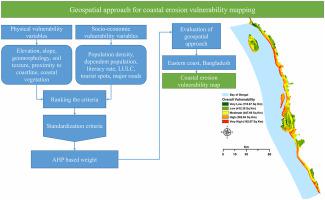
Abstract Coastal zones are physically, socially, and economically important. However, many coastal zones are highly vulnerable to coastal erosion due to high population density, tourist attractions, developed economy, and lowland. Erosion vulnerability assessment with limited criteria and components cannot provide detailed and accurate results. Therefore, an integrated vulnerability assessment of coastal erosion is essential to produce detailed and accurate erosion vulnerability information to support mitigation strategies. This study aims to prepare an integrated coastal erosion vulnerability approach using geospatial techniques and examine the pattern of vulnerability to coastal erosion effects in the eastern coastal region of Bangladesh. Thirteen spatial criteria under two components of vulnerability, namely, physical and socio-economic vulnerability, were assessed. These criteria were weighted on the basis of the analytical hierarchy process (AHP) and then combined to generate individual vulnerability indices. Finally, the overall vulnerability map was produced by integrating physical and social vulnerability indices. Results showed that the area of very high vulnerability includes 11% of the region, and the area of high vulnerability was 24%. Parts of Chittagong Port, Cox's Bazar, Kutubdia, Teknaf, Ukhia, Anowara, and some portions of Moheshkhali regions close to the coastline of the study site are likely to experience high vulnerability of coastal erosion impacts. The area was classified as a low- and very-low-vulnerability zone, representing 27% and 8%, respectively. For evaluating the efficiency of the outcome, the receiver operating characteristics (ROC) technique was used to validate the physical erosion vulnerability results, which stated an 85.2% success rate and 80.1% prediction rate of the produced results. The findings can be used by concerned authorities to protect coastal erosion and minimise its effects on properties and coastal environments.
中文翻译:

使用地理空间技术对孟加拉国东海岸的海岸侵蚀脆弱性进行评估
摘要 沿海地区在物理、社会和经济上都很重要。然而,由于人口密度高、旅游景点、经济发达和低地,许多沿海地区极易受到海岸侵蚀。具有有限标准和组件的侵蚀脆弱性评估无法提供详细和准确的结果。因此,海岸侵蚀的综合脆弱性评估对于生成详细和准确的侵蚀脆弱性信息以支持缓解策略至关重要。本研究旨在使用地理空间技术准备综合海岸侵蚀脆弱性方法,并检查孟加拉国东部沿海地区海岸侵蚀影响的脆弱性模式。脆弱性的两个组成部分下的 13 个空间标准,即 对身体和社会经济脆弱性进行了评估。这些标准在层次分析过程 (AHP) 的基础上加权,然后结合起来生成单独的脆弱性指数。最后,通过整合物理和社会脆弱性指数生成整体脆弱性地图。结果表明,极高脆弱性区域占该区域的11%,高度脆弱性区域为24%。吉大港港的部分地区、考克斯巴扎尔、库图布迪亚、泰克纳夫、乌基亚、阿诺瓦拉和靠近研究地点海岸线的莫赫什哈利地区的部分地区很可能遭受海岸侵蚀影响的高度脆弱性。该地区被归类为低脆弱性和极低脆弱性区域,分别占 27% 和 8%。为了评估结果的效率,接收器操作特性(ROC)技术用于验证物理侵蚀脆弱性结果,其表明所产生结果的成功率为85.2%和80.1%的预测率。有关当局可以利用这些发现来保护海岸侵蚀,并将其对财产和海岸环境的影响降至最低。
更新日期:2021-01-01
中文翻译:
使用地理空间技术对孟加拉国东海岸的海岸侵蚀脆弱性进行评估
摘要 沿海地区在物理、社会和经济上都很重要。然而,由于人口密度高、旅游景点、经济发达和低地,许多沿海地区极易受到海岸侵蚀。具有有限标准和组件的侵蚀脆弱性评估无法提供详细和准确的结果。因此,海岸侵蚀的综合脆弱性评估对于生成详细和准确的侵蚀脆弱性信息以支持缓解策略至关重要。本研究旨在使用地理空间技术准备综合海岸侵蚀脆弱性方法,并检查孟加拉国东部沿海地区海岸侵蚀影响的脆弱性模式。脆弱性的两个组成部分下的 13 个空间标准,即 对身体和社会经济脆弱性进行了评估。这些标准在层次分析过程 (AHP) 的基础上加权,然后结合起来生成单独的脆弱性指数。最后,通过整合物理和社会脆弱性指数生成整体脆弱性地图。结果表明,极高脆弱性区域占该区域的11%,高度脆弱性区域为24%。吉大港港的部分地区、考克斯巴扎尔、库图布迪亚、泰克纳夫、乌基亚、阿诺瓦拉和靠近研究地点海岸线的莫赫什哈利地区的部分地区很可能遭受海岸侵蚀影响的高度脆弱性。该地区被归类为低脆弱性和极低脆弱性区域,分别占 27% 和 8%。为了评估结果的效率,接收器操作特性(ROC)技术用于验证物理侵蚀脆弱性结果,其表明所产生结果的成功率为85.2%和80.1%的预测率。有关当局可以利用这些发现来保护海岸侵蚀,并将其对财产和海岸环境的影响降至最低。


 京公网安备 11010802027423号