当前位置:
X-MOL 学术
›
J. Hydrol.
›
论文详情
Our official English website, www.x-mol.net, welcomes your
feedback! (Note: you will need to create a separate account there.)
Runoff formation in a catchment with Peat bog and Podzol hillslopes
Journal of Hydrology ( IF 5.9 ) Pub Date : 2021-02-01 , DOI: 10.1016/j.jhydrol.2020.125633 Lukáš Vlček , Václav Šípek , Jitka Kofroňová , Jan Kocum , Tomáš Doležal , Bohumír Janský
Journal of Hydrology ( IF 5.9 ) Pub Date : 2021-02-01 , DOI: 10.1016/j.jhydrol.2020.125633 Lukáš Vlček , Václav Šípek , Jitka Kofroňová , Jan Kocum , Tomáš Doležal , Bohumír Janský
|
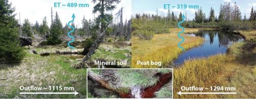
Abstract Hydrological behavior of an ombrogenous raised peat bog has been observed and described in many studies; however, not in complexity with other soils. This research deals with the hydrological function of peat bog in a catchment where peat bog (formed by Histosol or other hydromorphic soils) covers only a part of the area (40–60%). Two soil types, creating two main hillslopes of the experimental catchment in this study, form the dominant soil types (Podzol and Histosol) in the Sumava Mountains, Czechia. A modified HBV model was used to estimate the contribution of each soil type to common outflow and for the estimation of the water balance. According to previous research and field observations, dominant hydrological processes were described for each hillslope (soil). The HBV model was used for the quantification of a ratio between fast and slow flow at Peat bog hillslope and Podzol hillslope. At Peat bog hillslope, the majority of outflow (67%) was formed from the upper soil layer (Acrotelm). In the mineral soil hillslope, a larger portion of runoff was generated from the lower soil layers or bedrock interface (61%). Peat bog contributes to a stream mainly during rainfall events; however, the model showed also significant deep percolation at the Peat bog hillslope and considerable contribution to baseflow during a year. Generally, more precipitation water was turned by the model into runoff at the Peat bog hillslope, which was also exhibited by a lower rate of actual evapotranspiration (21% of precipitation), compared to 29% in the case of Podzol hillslope. If we consider land-use changes in this locality in terms of expanding or reducing peat areas (draining, drains damming, droughts, etc.), this model could sufficiently estimate the hydrological behavior of local streams and thus can be potentially used in hydrological planning by local authorities.
中文翻译:

泥炭沼泽和 Podzol 山坡集水区的径流形成
摘要 在许多研究中已经观察到并描述了异质凸起泥炭沼泽的水文行为;然而,与其他土壤相比并不复杂。这项研究涉及泥炭沼泽在集水区的水文功能,其中泥炭沼泽(由 Histosol 或其他水质土壤形成)仅覆盖该地区的一部分(40-60%)。两种土壤类型构成了本研究中实验集水区的两个主要山坡,形成了捷克苏马瓦山脉的主要土壤类型(Podzol 和 Histosol)。修改后的 HBV 模型用于估计每种土壤类型对共同流出量的贡献,并用于估计水平衡。根据之前的研究和实地观察,每个山坡(土壤)都描述了主要的水文过程。HBV 模型用于量化 Peat bog hillslope 和 Podzol hillslope 的快速和慢速流动之间的比率。在泥炭沼泽山坡,大部分流出物 (67%) 来自上层土壤 (Acrotelm)。在矿质土壤山坡中,较大部分的径流来自较低的土层或基岩界面(61%)。泥炭沼泽主要在降雨事件期间形成河流;然而,该模型在泥炭沼泽山坡上也显示出显着的深层渗透,并对一年中的基流贡献很大。通常,更多的降水被模型转化为泥炭沼泽山坡的径流,与 Podzol 山坡的 29% 相比,实际蒸散率较低(降水的 21%)也表现出这一点。
更新日期:2021-02-01
中文翻译:
泥炭沼泽和 Podzol 山坡集水区的径流形成
摘要 在许多研究中已经观察到并描述了异质凸起泥炭沼泽的水文行为;然而,与其他土壤相比并不复杂。这项研究涉及泥炭沼泽在集水区的水文功能,其中泥炭沼泽(由 Histosol 或其他水质土壤形成)仅覆盖该地区的一部分(40-60%)。两种土壤类型构成了本研究中实验集水区的两个主要山坡,形成了捷克苏马瓦山脉的主要土壤类型(Podzol 和 Histosol)。修改后的 HBV 模型用于估计每种土壤类型对共同流出量的贡献,并用于估计水平衡。根据之前的研究和实地观察,每个山坡(土壤)都描述了主要的水文过程。HBV 模型用于量化 Peat bog hillslope 和 Podzol hillslope 的快速和慢速流动之间的比率。在泥炭沼泽山坡,大部分流出物 (67%) 来自上层土壤 (Acrotelm)。在矿质土壤山坡中,较大部分的径流来自较低的土层或基岩界面(61%)。泥炭沼泽主要在降雨事件期间形成河流;然而,该模型在泥炭沼泽山坡上也显示出显着的深层渗透,并对一年中的基流贡献很大。通常,更多的降水被模型转化为泥炭沼泽山坡的径流,与 Podzol 山坡的 29% 相比,实际蒸散率较低(降水的 21%)也表现出这一点。


 京公网安备 11010802027423号