Ecological Indicators ( IF 7.0 ) Pub Date : 2020-10-13 , DOI: 10.1016/j.ecolind.2020.106988 Abbas El-Zein , Tanvir Ahmed , Fahim Tonmoy
|
Assessments of vulnerability to flooding can generate useful data for planners and policy makers. To the best of the authors knowledge, no flood-vulnerability study has combined geophysical modelling of floods with socio-economic assessments of vulnerability at finer municipal or household scale. In addition, the extent to which vulnerability assessments actually feed into flood adaptation policies remains largely unknown.
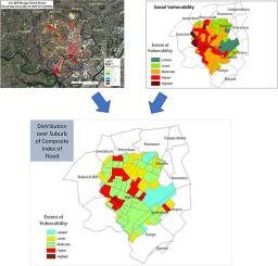
A new flood vulnerability index, and associated methodology, is proposed, combining high-resolution hydrological-hydraulic modelling with built-environment and socio-economic indicators at the smallest spatial scale at which socio-economic data is available. The main advantage of the methodology is its ability to incorporate place-specific data, hence yielding more refined simulations of floods and the capacity to make projections into climate futures at local scale. The index is built and applied to the inter-city suburb of Marrickville in Sydney and used to assess the effects of future climate change on vulnerability mapping in the suburb. Finally, the results of the assessment are presented to, and discussed with, the local government authority responsible for implementing flood adaptation policies for Marrickville.
Locally specific modelling of floods, combined with socio-economic and built-environment mapping, has yielded a rich set of information on flood vulnerability and significant variability within a single suburb. Flood duration is projected to increase by more than 100% under some climate change scenarios, as a result of reduced drainage caused by sea level rise. Feedback from municipal council has highlighted the potential usefulness of the knowledge generated by the assessment, especially for emergency services.
中文翻译:
气候变化下市政规模的洪水对地球物理和社会的脆弱性:以悉尼市中心城区为例
对洪灾脆弱性的评估可以为规划者和决策者提供有用的数据。据作者所知,尚无洪水脆弱性研究将洪水的地球物理模型与更精细的市政或家庭规模的脆弱性的社会经济评估相结合。此外,脆弱性评估实际上在多大程度上适应了洪水适应政策。
提出了一种新的洪水脆弱性指数及相关方法,将高分辨率水文水力模型与在可获得社会经济数据的最小空间尺度上的内置环境和社会经济指标相结合。该方法的主要优点是它能够结合特定地点的数据,因此可以对洪水进行更精细的模拟,并具有在本地范围内对气候未来进行预测的能力。该指数是建立并应用于悉尼的马里克维尔市郊郊区,用于评估未来气候变化对郊区脆弱性制图的影响。最后,评估结果已提交给负责实施Marrickville洪水适应政策的地方政府部门,并与之讨论。
结合当地的洪水模型,社会经济模型和内置环境图,已经获得了关于单个郊区洪水脆弱性和重大变化的丰富信息。在某些气候变化情景下,由于海平面上升导致排水量减少,预计洪水持续时间将增加100%以上。市议会的反馈突出了评估产生的知识的潜在用途,特别是对于紧急服务。


 京公网安备 11010802027423号