Geoscience Frontiers ( IF 8.5 ) Pub Date : 2020-10-11 , DOI: 10.1016/j.gsf.2020.09.012 Chu Wu , Chen Fang , Xiong Wu , Ge Zhu , Yuzhe Zhang
|
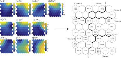
Water resources are scarce in arid or semiarid areas, which not only limits economic development, but also threatens the survival of mankind. The local communities around the Hangjinqi gasfield depend on groundwater sources for water supply. A clear understanding of the groundwater hydrogeochemical characteristics and the groundwater quality and its seasonal cycle is invaluable and indispensable for groundwater protection and management. In this study, self- organizing maps were used in combination with the quantization and topographic errors and K-means clustering method to investigate groundwater chemistry datasets. The Piper and Gibbs diagrams and saturation index were systematically applied to investigate the hydrogeochemical characteristics of groundwater from both rainy and dry seasons. Further, the entropy-weighted theory was used to characterize groundwater quality and assess its seasonal variability and suitability for drinking purposes. Our hydrochemical groundwater dataset, consisting of 10 parameters measured during both dry and rainy seasons, was classified into 6 clusters, and the Piper diagram revealed three hydrochemical facies: Cl-Na type (clusters 1, 2 and 3), mixed type (clusters 4 and 5), and HCO3-Ca type (cluster 6). The Gibbs diagram and saturation index suggested that weathering of rock-forming minerals were the primary process controlling groundwater chemical composition and validated the credibility and practicality of the clustering results. Two-thirds of 45 groundwater samples were categorized as excellent- or good-quality and were suitable as drinking water. Cluster changes within the same and different clusters from the dry season to the rainy season were detected in approximately 78% of the collected samples. The main factors affecting the groundwater quality were hydrogeochemical characteristics, and dry season groundwater quality was better than rainy season groundwater quality. Based on this work, such results can be used to investigate the seasonal variation of hydrogeochemical characteristics and assess water quality accurately in the others similar area.
中文翻译:
西北地区鄂尔多斯盆地杭金旗气田地区的自组织图对地下水的水文地球化学特征和水质评价
干旱或半干旱地区的水资源稀缺,这不仅限制了经济发展,而且还威胁着人类的生存。杭锦旗气田周围的当地社区依靠地下水来供水。对地下水水文地球化学特征,地下水质量及其季节性周期的清晰了解对于地下水的保护和管理而言是不可或缺的。在这项研究中,将自组织图与量化和地形误差以及K-均值聚类方法结合使用来研究地下水化学数据集。系统地运用Piper和Gibbs图及饱和度指数研究雨季和旱季的地下水水文地球化学特征。进一步,熵权理论被用来表征地下水水质,并评估其季节性变化和适合饮用目的。我们的水化学地下水数据集由在干旱和雨季期间测量的10个参数组成,分为6个类,Piper图显示了3个水化学相:Cl-Na型(第1、2和3类),混合型(第4类)。和5),以及HCO3-Ca类型(群集6)。吉布斯图和饱和指数表明,成岩矿物的风化是控制地下水化学成分的主要过程,并验证了聚类结果的可信度和实用性。在45个地下水样本中,有三分之二被归类为优质水质,适合作为饮用水。在大约78%的采集样本中,检测到了从干旱季节到雨季相同和不同集群中的集群变化。影响地下水水质的主要因素是水文地球化学特征,旱季地下水水质优于雨季地下水水质。基于这项工作,


 京公网安备 11010802027423号